Note:
The expiration time in the watch graphic is amended if the watch is
replaced, cancelled or extended.
Note:
Note:
The expiration time in the watch graphic is amended if the watch is
replaced, cancelled or extended.
Note: Click for
Watch Status Reports.
SEL3
URGENT - IMMEDIATE BROADCAST REQUESTED
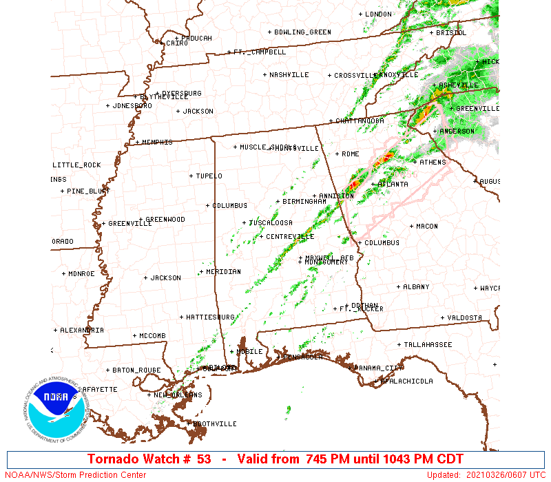
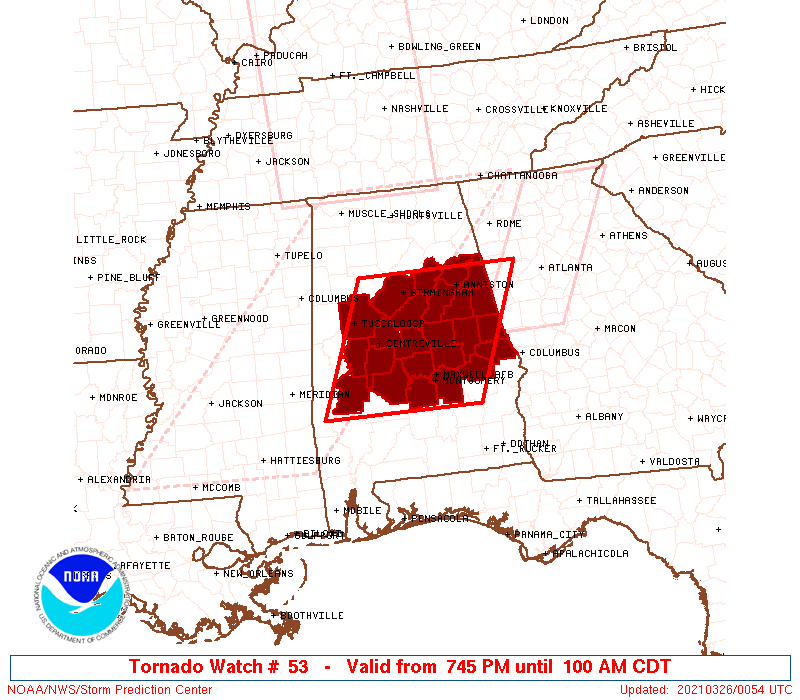
Tornado Watch Number 53
NWS Storm Prediction Center Norman OK
745 PM CDT Thu Mar 25 2021
The NWS Storm Prediction Center has issued a
* Tornado Watch for portions of
Central Alabama
* Effective this Thursday night and Friday morning from 745 PM
until 100 AM CDT.
* Primary threats include...
A few tornadoes and a couple intense tornadoes possible
Isolated damaging wind gusts to 70 mph possible
Isolated large hail events to 1.5 inches in diameter possible
SUMMARY...A cluster with embedded supercell structures should
progress east-northeast from west-central to east-central Alabama
offering a continued threat for a few tornadoes.
The tornado watch area is approximately along and 75 statute miles
east and west of a line from 25 miles northwest of Anniston AL to 30
miles south of Selma AL. For a complete depiction of the watch see
the associated watch outline update (WOUS64 KWNS WOU3).
PRECAUTIONARY/PREPAREDNESS ACTIONS...
REMEMBER...A Tornado Watch means conditions are favorable for
tornadoes and severe thunderstorms in and close to the watch
area. Persons in these areas should be on the lookout for
threatening weather conditions and listen for later statements
and possible warnings.
&&
OTHER WATCH INFORMATION...CONTINUE...WW 50...WW 51...WW 52...
AVIATION...Tornadoes and a few severe thunderstorms with hail
surface and aloft to 1.5 inches. Extreme turbulence and surface wind
gusts to 60 knots. A few cumulonimbi with maximum tops to 500. Mean
storm motion vector 24035.
...Grams
 Note:
The Aviation Watch (SAW) product is an approximation to the watch area.
The actual watch is depicted by the shaded areas.
Note:
The Aviation Watch (SAW) product is an approximation to the watch area.
The actual watch is depicted by the shaded areas.
   SAW3
   WW 53 TORNADO AL 260045Z - 260600Z
   AXIS..75 STATUTE MILES EAST AND WEST OF LINE..
   25NW ANB/ANNISTON AL/ - 30S SEM/SELMA AL/
   ..AVIATION COORDS.. 65NM E/W /38ENE VUZ - 38WSW MGM/
   HAIL SURFACE AND ALOFT..1.5 INCHES. WIND GUSTS..60 KNOTS.
   MAX TOPS TO 500. MEAN STORM MOTION VECTOR 24035.

   LAT...LON 33838485 31918570 31918826 33838746

   THIS IS AN APPROXIMATION TO THE WATCH AREA.  FOR A
   COMPLETE DEPICTION OF THE WATCH SEE WOUS64 KWNS
   FOR WOU3.
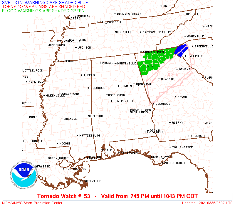
Watch 53 Status Report Messages:
STATUS REPORT #2 ON WW 53

VALID 260250Z - 260330Z

SEVERE WEATHER THREAT CONTINUES RIGHT OF A LINE FROM 10 NE AUO TO
45 N MGM TO 10 SSW ANB TO 10 S GAD.

FOR ADDITIONAL INFORMATION SEE MESOSCALE DISCUSSION 266

..SMITH..03/26/21

ATTN...WFO...BMX...

&&

STATUS REPORT FOR WT 53

SEVERE WEATHER THREAT CONTINUES FOR THE FOLLOWING AREAS

ALC015-017-027-029-037-111-123-260330-

AL
.    ALABAMA COUNTIES INCLUDED ARE

CALHOUN 	     CHAMBERS		 CLAY
CLEBURNE	     COOSA		 RANDOLPH
TALLAPOOSA
$$


THE WATCH STATUS MESSAGE IS FOR GUIDANCE PURPOSES ONLY.  PLEASE
REFER TO WATCH COUNTY NOTIFICATION STATEMENTS FOR OFFICIAL
INFORMATION ON COUNTIES...INDEPENDENT CITIES AND MARINE ZONES
CLEARED FROM SEVERE THUNDERSTORM AND TORNADO WATCHES.
$$

STATUS REPORT #1 ON WW 53

VALID 260220Z - 260300Z

SEVERE WEATHER THREAT CONTINUES RIGHT OF A LINE FROM 25 ENE TOI
TO 45 NNW MGM TO 20 SW GAD.

FOR ADDITIONAL INFORMATION SEE MESOSCALE DISCUSSION 266

..SMITH..03/26/21

ATTN...WFO...BMX...

&&

STATUS REPORT FOR WT 53

SEVERE WEATHER THREAT CONTINUES FOR THE FOLLOWING AREAS

ALC015-017-027-029-037-051-081-087-111-115-121-123-260300-

AL
.    ALABAMA COUNTIES INCLUDED ARE

CALHOUN 	     CHAMBERS		 CLAY
CLEBURNE	     COOSA		 ELMORE
LEE		     MACON		 RANDOLPH
ST. CLAIR	     TALLADEGA		 TALLAPOOSA
$$


THE WATCH STATUS MESSAGE IS FOR GUIDANCE PURPOSES ONLY.  PLEASE
REFER TO WATCH COUNTY NOTIFICATION STATEMENTS FOR OFFICIAL
INFORMATION ON COUNTIES...INDEPENDENT CITIES AND MARINE ZONES
CLEARED FROM SEVERE THUNDERSTORM AND TORNADO WATCHES.
$$
Note:
Click for Complete Product Text.
Tornadoes
Probability of 2 or more tornadoes
|
Mod (50%)
|
Probability of 1 or more strong (EF2-EF5) tornadoes
|
Mod (30%)
|
Wind
Probability of 10 or more severe wind events
|
Mod (30%)
|
Probability of 1 or more wind events > 65 knots
|
Low (10%)
|
Hail
Probability of 10 or more severe hail events
|
Low (20%)
|
Probability of 1 or more hailstones > 2 inches
|
Low (10%)
|
Combined Severe Hail/Wind
Probability of 6 or more combined severe hail/wind events
|
Mod (50%)
|
For each watch, probabilities for particular events inside the watch
(listed above in each table) are determined by the issuing forecaster.
The "Low" category contains probability values ranging from less than 2%
to 20% (EF2-EF5 tornadoes), less than 5% to 20% (all other probabilities),
"Moderate" from 30% to 60%, and "High" from 70% to greater than 95%.
High values are bolded and lighter in color to provide awareness of
an increased threat for a particular event.


 @NWSSPC