|
Initial List of Counties in SPC Tornado Watch 52 (WOU)
|
Back to Watch 52
|
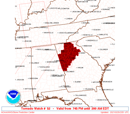 |
   WOUS64 KWNS 252343
   WOU2

   BULLETIN - IMMEDIATE BROADCAST REQUESTED
   TORNADO WATCH OUTLINE UPDATE FOR WT 52
   NWS STORM PREDICTION CENTER NORMAN OK
   745 PM EDT THU MAR 25 2021

   TORNADO WATCH 52 IS IN EFFECT UNTIL 200 AM EDT FOR THE
    FOLLOWING LOCATIONS

   GAC011-013-015-045-057-059-063-067-077-085-089-097-111-113-117-
   121-123-135-139-143-145-149-151-157-187-195-199-217-219-223-227-
   231-233-247-255-285-291-297-311-260600-
   /O.NEW.KWNS.TO.A.0052.210325T2345Z-210326T0600Z/

   GA
   .    GEORGIA COUNTIES INCLUDED ARE

   BANKS                BARROW              BARTOW
   CARROLL              CHEROKEE            CLARKE
   CLAYTON              COBB                COWETA
   DAWSON               DEKALB              DOUGLAS
   FANNIN               FAYETTE             FORSYTH
   FULTON               GILMER              GWINNETT
   HALL                 HARALSON            HARRIS
   HEARD                HENRY               JACKSON
   LUMPKIN              MADISON             MERIWETHER
   NEWTON               OCONEE              PAULDING
   PICKENS              PIKE                POLK
   ROCKDALE             SPALDING            TROUP
   UNION                WALTON              WHITE


   ATTN...WFO...FFC...
|
| Aviation Watch (SAW) for WW52 |
|---|
 |
| Note:
The Aviation Watch (SAW) product is an approximation to the watch area.
The actual watch is depicted by the shaded areas. |
   SAW2
   WW 52 TORNADO GA 252345Z - 260600Z
   AXIS..40 STATUTE MILES EAST AND WEST OF LINE..
   95NNE ATL/ATLANTA GA/ - 15SE LGC/LA GRANGE GA/
   ..AVIATION COORDS.. 35NM E/W /27WNW ODF - 20SE LGC/
   HAIL SURFACE AND ALOFT..1 INCH. WIND GUSTS..60 KNOTS.
   MAX TOPS TO 500. MEAN STORM MOTION VECTOR 23040.

   LAT...LON 34908308 32848420 32848558 34908449

   THIS IS AN APPROXIMATION TO THE WATCH AREA.  FOR A
   COMPLETE DEPICTION OF THE WATCH SEE WOUS64 KWNS
   FOR WOU2.
|
|


 @NWSSPC
