Note:
The expiration time in the watch graphic is amended if the watch is
replaced, cancelled or extended.
Note:
Note:
The expiration time in the watch graphic is amended if the watch is
replaced, cancelled or extended.
Note: Click for
Watch Status Reports.
SEL9
URGENT - IMMEDIATE BROADCAST REQUESTED
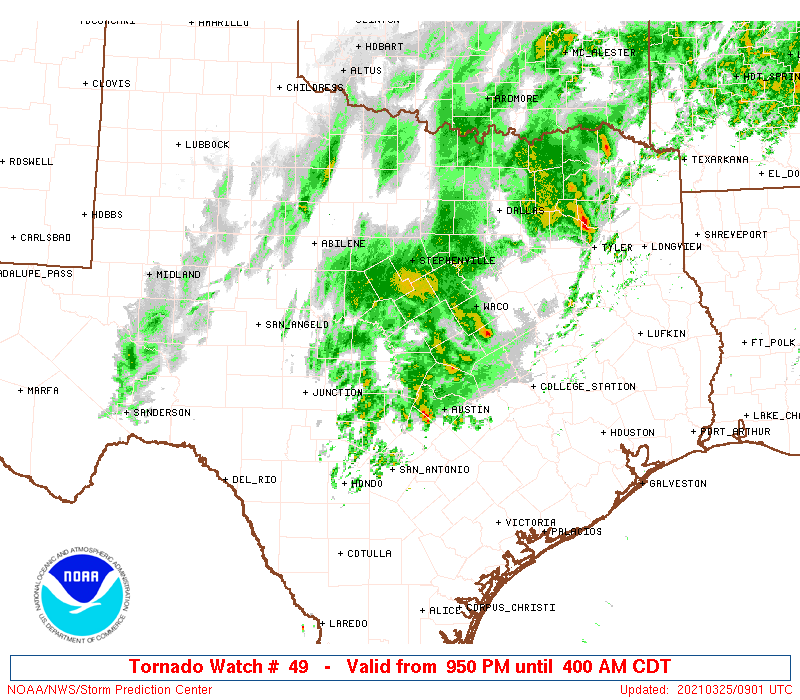
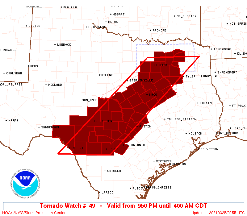
Tornado Watch Number 49
NWS Storm Prediction Center Norman OK
950 PM CDT Wed Mar 24 2021
The NWS Storm Prediction Center has issued a
* Tornado Watch for portions of
Central to northeast Texas
* Effective this Wednesday night and Thursday morning from 950 PM
until 400 AM CDT.
* Primary threats include...
A couple tornadoes possible
Scattered damaging winds and isolated significant gusts to 80
mph possible
Scattered large hail and isolated very large hail events to 2.5
inches in diameter possible
SUMMARY...Multiple clusters of supercells are expected to persist
through the overnight. The potential for more intense clusters
should emanate east-northeast from the Edwards Plateau towards the
I-35 corridor in central Texas.
The tornado watch area is approximately along and 75 statute miles
east and west of a line from 60 miles east northeast of Dallas TX to
45 miles east southeast of Del Rio TX. For a complete depiction of
the watch see the associated watch outline update (WOUS64 KWNS
WOU9).
PRECAUTIONARY/PREPAREDNESS ACTIONS...
REMEMBER...A Tornado Watch means conditions are favorable for
tornadoes and severe thunderstorms in and close to the watch
area. Persons in these areas should be on the lookout for
threatening weather conditions and listen for later statements
and possible warnings.
&&
OTHER WATCH INFORMATION...CONTINUE...WW 47...WW 48...
AVIATION...Tornadoes and a few severe thunderstorms with hail
surface and aloft to 2.5 inches. Extreme turbulence and surface wind
gusts to 70 knots. A few cumulonimbi with maximum tops to 550. Mean
storm motion vector 22030.
...Grams
 Note:
The Aviation Watch (SAW) product is an approximation to the watch area.
The actual watch is depicted by the shaded areas.
Note:
The Aviation Watch (SAW) product is an approximation to the watch area.
The actual watch is depicted by the shaded areas.
   SAW9
   WW 49 TORNADO TX 250250Z - 250900Z
   AXIS..75 STATUTE MILES EAST AND WEST OF LINE..
   60ENE DAL/DALLAS TX/ - 45ESE DRT/DEL RIO TX/
   ..AVIATION COORDS.. 65NM E/W /61ENE TTT - 32ESE DLF/
   HAIL SURFACE AND ALOFT..2.5 INCHES. WIND GUSTS..70 KNOTS.
   MAX TOPS TO 550. MEAN STORM MOTION VECTOR 22030.

   LAT...LON 33169459 29119899 29110147 33169719

   THIS IS AN APPROXIMATION TO THE WATCH AREA.  FOR A
   COMPLETE DEPICTION OF THE WATCH SEE WOUS64 KWNS
   FOR WOU9.
Watch 49 Status Report Messages:
STATUS REPORT #6 ON WW 49

VALID 250815Z - 250900Z

SEVERE WEATHER THREAT CONTINUES RIGHT OF A LINE FROM 20 SSW HDO
TO 25 NNW BAZ TO 25 NE AUS TO 35 S CRS TO 25 WNW TYR TO 30 NNW
GGG.

WW 49 WILL BE ALLOWED TO EXPIRE AT 250900Z.

..LEITMAN..03/25/21

ATTN...WFO...EWX...FWD...SJT...

&&

STATUS REPORT FOR WT 49

SEVERE WEATHER THREAT CONTINUES FOR THE FOLLOWING AREAS

TXC029-091-161-209-213-453-467-250900-

TX
.    TEXAS COUNTIES INCLUDED ARE

BEXAR		     COMAL		 FREESTONE
HAYS		     HENDERSON		 TRAVIS
VAN ZANDT
$$


THE WATCH STATUS MESSAGE IS FOR GUIDANCE PURPOSES ONLY.  PLEASE
REFER TO WATCH COUNTY NOTIFICATION STATEMENTS FOR OFFICIAL
INFORMATION ON COUNTIES...INDEPENDENT CITIES AND MARINE ZONES
CLEARED FROM SEVERE THUNDERSTORM AND TORNADO WATCHES.
$$

STATUS REPORT #5 ON WW 49

VALID 250725Z - 250840Z

SEVERE WEATHER THREAT CONTINUES RIGHT OF A LINE FROM 45 WSW HDO
TO 25 N HDO TO 35 W AUS TO 25 SSE TPL TO 25 E ACT TO 15 N CRS TO
45 WSW TXK.

FOR ADDITIONAL INFORMATION SEE MESOSCALE DISCUSSION 250.

..LEITMAN..03/25/21

ATTN...WFO...EWX...FWD...SJT...

&&

STATUS REPORT FOR WT 49

SEVERE WEATHER THREAT CONTINUES FOR THE FOLLOWING AREAS

TXC019-029-031-091-145-161-209-213-259-293-325-349-453-467-491-
250840-

TX
.    TEXAS COUNTIES INCLUDED ARE

BANDERA 	     BEXAR		 BLANCO
COMAL		     FALLS		 FREESTONE
HAYS		     HENDERSON		 KENDALL
LIMESTONE	     MEDINA		 NAVARRO
TRAVIS		     VAN ZANDT		 WILLIAMSON
$$


THE WATCH STATUS MESSAGE IS FOR GUIDANCE PURPOSES ONLY.  PLEASE
REFER TO WATCH COUNTY NOTIFICATION STATEMENTS FOR OFFICIAL
INFORMATION ON COUNTIES...INDEPENDENT CITIES AND MARINE ZONES
CLEARED FROM SEVERE THUNDERSTORM AND TORNADO WATCHES.
$$

STATUS REPORT #4 ON WW 49

VALID 250630Z - 250740Z

SEVERE WEATHER THREAT CONTINUES RIGHT OF A LINE FROM 30 SE DRT TO
45 S JCT TO 60 WNW AUS TO 30 W TPL TO 20 WNW CRS TO 35 NW TYR TO
25 SE PRX.

..LEITMAN..03/25/21

ATTN...WFO...EWX...FWD...SJT...

&&

STATUS REPORT FOR WT 49

SEVERE WEATHER THREAT CONTINUES FOR THE FOLLOWING AREAS

TXC019-027-029-031-053-091-145-161-171-209-213-217-223-257-259-
265-293-309-325-349-379-385-453-463-467-491-250740-

TX
.    TEXAS COUNTIES INCLUDED ARE

BANDERA 	     BELL		 BEXAR
BLANCO		     BURNET		 COMAL
FALLS		     FREESTONE		 GILLESPIE
HAYS		     HENDERSON		 HILL
HOPKINS 	     KAUFMAN		 KENDALL
KERR		     LIMESTONE		 MCLENNAN
MEDINA		     NAVARRO		 RAINS
REAL		     TRAVIS		 UVALDE
VAN ZANDT	     WILLIAMSON
$$


THE WATCH STATUS MESSAGE IS FOR GUIDANCE PURPOSES ONLY.  PLEASE
REFER TO WATCH COUNTY NOTIFICATION STATEMENTS FOR OFFICIAL
INFORMATION ON COUNTIES...INDEPENDENT CITIES AND MARINE ZONES
CLEARED FROM SEVERE THUNDERSTORM AND TORNADO WATCHES.
$$

STATUS REPORT #3 ON WW 49

VALID 250535Z - 250640Z

SEVERE WEATHER THREAT CONTINUES RIGHT OF A LINE FROM 15 SW DRT TO
25 ESE JCT TO 65 WNW AUS TO 35 W ACT TO 15 SE DAL TO 15 SSE PRX.

..LEITMAN..03/25/21

ATTN...WFO...EWX...FWD...SJT...

&&

STATUS REPORT FOR WT 49

SEVERE WEATHER THREAT CONTINUES FOR THE FOLLOWING AREAS

TXC019-027-029-031-035-053-091-099-119-139-145-161-171-209-213-
217-223-231-257-259-265-271-281-293-299-309-325-349-379-385-453-
463-467-491-250640-

TX
.    TEXAS COUNTIES INCLUDED ARE

BANDERA 	     BELL		 BEXAR
BLANCO		     BOSQUE		 BURNET
COMAL		     CORYELL		 DELTA
ELLIS		     FALLS		 FREESTONE
GILLESPIE	     HAYS		 HENDERSON
HILL		     HOPKINS		 HUNT
KAUFMAN 	     KENDALL		 KERR
KINNEY		     LAMPASAS		 LIMESTONE
LLANO		     MCLENNAN		 MEDINA
NAVARRO 	     RAINS		 REAL
TRAVIS		     UVALDE		 VAN ZANDT
WILLIAMSON
$$


THE WATCH STATUS MESSAGE IS FOR GUIDANCE PURPOSES ONLY.  PLEASE
REFER TO WATCH COUNTY NOTIFICATION STATEMENTS FOR OFFICIAL
INFORMATION ON COUNTIES...INDEPENDENT CITIES AND MARINE ZONES
CLEARED FROM SEVERE THUNDERSTORM AND TORNADO WATCHES.
$$

STATUS REPORT #2 ON WW 49

VALID 250455Z - 250540Z

SEVERE WEATHER THREAT CONTINUES RIGHT OF A LINE FROM 10 WNW DRT
TO 50 S BWD TO 25 NNE DAL.

FOR ADDITIONAL INFORMATION SEE MESOSCALE DISCUSSION 249

..SMITH..03/25/21

ATTN...WFO...EWX...FWD...SJT...

&&

STATUS REPORT FOR WT 49

SEVERE WEATHER THREAT CONTINUES FOR THE FOLLOWING AREAS

TXC019-027-029-031-035-053-091-099-119-137-139-145-161-171-193-
209-213-217-223-231-251-257-259-265-267-271-281-293-299-309-319-
325-333-349-379-385-397-411-453-463-465-467-491-250540-

TX
.    TEXAS COUNTIES INCLUDED ARE

BANDERA 	     BELL		 BEXAR
BLANCO		     BOSQUE		 BURNET
COMAL		     CORYELL		 DELTA
EDWARDS 	     ELLIS		 FALLS
FREESTONE	     GILLESPIE		 HAMILTON
HAYS		     HENDERSON		 HILL
HOPKINS 	     HUNT		 JOHNSON
KAUFMAN 	     KENDALL		 KERR
KIMBLE		     KINNEY		 LAMPASAS
LIMESTONE	     LLANO		 MCLENNAN
MASON		     MEDINA		 MILLS
NAVARRO 	     RAINS		 REAL
ROCKWALL	     SAN SABA		 TRAVIS
UVALDE		     VAL VERDE		 VAN ZANDT
WILLIAMSON
$$


THE WATCH STATUS MESSAGE IS FOR GUIDANCE PURPOSES ONLY.  PLEASE
REFER TO WATCH COUNTY NOTIFICATION STATEMENTS FOR OFFICIAL
INFORMATION ON COUNTIES...INDEPENDENT CITIES AND MARINE ZONES
CLEARED FROM SEVERE THUNDERSTORM AND TORNADO WATCHES.
$$

STATUS REPORT #1 ON WW 49

VALID 250335Z - 250440Z

THE SEVERE WEATHER THREAT CONTINUES ACROSS THE ENTIRE WATCH AREA.

FOR ADDITIONAL INFORMATION SEE MESOSCALE DISCUSSION 247

..SMITH..03/25/21

ATTN...WFO...EWX...FWD...SJT...

&&

STATUS REPORT FOR WT 49

SEVERE WEATHER THREAT CONTINUES FOR THE FOLLOWING AREAS

TXC019-027-029-031-035-053-085-091-099-113-119-137-139-145-161-
171-193-209-213-217-223-231-251-257-259-265-267-271-281-293-299-
307-309-319-325-327-333-349-379-385-397-411-435-439-453-463-465-
467-491-250440-

TX
.    TEXAS COUNTIES INCLUDED ARE

BANDERA 	     BELL		 BEXAR
BLANCO		     BOSQUE		 BURNET
COLLIN		     COMAL		 CORYELL
DALLAS		     DELTA		 EDWARDS
ELLIS		     FALLS		 FREESTONE
GILLESPIE	     HAMILTON		 HAYS
HENDERSON	     HILL		 HOPKINS
HUNT		     JOHNSON		 KAUFMAN
KENDALL 	     KERR		 KIMBLE
KINNEY		     LAMPASAS		 LIMESTONE
LLANO		     MCCULLOCH		 MCLENNAN
MASON		     MEDINA		 MENARD
MILLS		     NAVARRO		 RAINS
REAL		     ROCKWALL		 SAN SABA
SUTTON		     TARRANT		 TRAVIS
UVALDE		     VAL VERDE		 VAN ZANDT
WILLIAMSON
$$


THE WATCH STATUS MESSAGE IS FOR GUIDANCE PURPOSES ONLY.  PLEASE
REFER TO WATCH COUNTY NOTIFICATION STATEMENTS FOR OFFICIAL
INFORMATION ON COUNTIES...INDEPENDENT CITIES AND MARINE ZONES
CLEARED FROM SEVERE THUNDERSTORM AND TORNADO WATCHES.
$$
Note:
Click for Complete Product Text.
Tornadoes
Probability of 2 or more tornadoes
|
Mod (30%)
|
Probability of 1 or more strong (EF2-EF5) tornadoes
|
Low (20%)
|
Wind
Probability of 10 or more severe wind events
|
Mod (40%)
|
Probability of 1 or more wind events > 65 knots
|
Mod (40%)
|
Hail
Probability of 10 or more severe hail events
|
Mod (40%)
|
Probability of 1 or more hailstones > 2 inches
|
Mod (40%)
|
Combined Severe Hail/Wind
Probability of 6 or more combined severe hail/wind events
|
High (70%)
|
For each watch, probabilities for particular events inside the watch
(listed above in each table) are determined by the issuing forecaster.
The "Low" category contains probability values ranging from less than 2%
to 20% (EF2-EF5 tornadoes), less than 5% to 20% (all other probabilities),
"Moderate" from 30% to 60%, and "High" from 70% to greater than 95%.
High values are bolded and lighter in color to provide awareness of
an increased threat for a particular event.


 @NWSSPC