 Note:
The expiration time in the watch graphic is amended if the watch is
replaced, cancelled or extended.
Note:
Note:
The expiration time in the watch graphic is amended if the watch is
replaced, cancelled or extended.
Note: Click for
Watch Status Reports.
SEL7
URGENT - IMMEDIATE BROADCAST REQUESTED
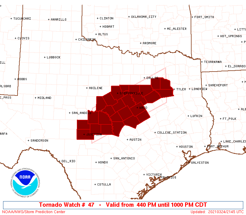
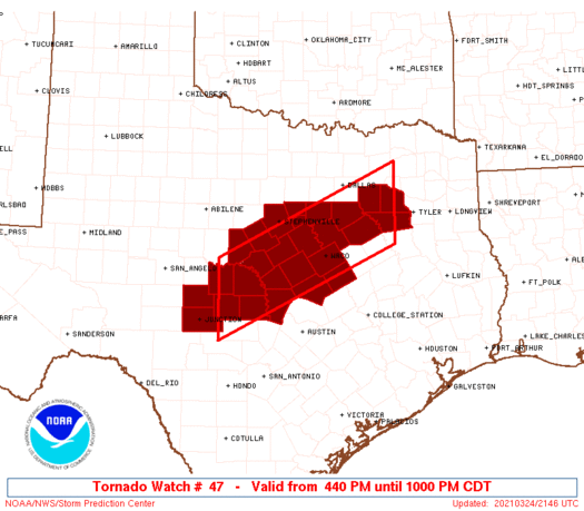
Tornado Watch Number 47
NWS Storm Prediction Center Norman OK
440 PM CDT Wed Mar 24 2021
The NWS Storm Prediction Center has issued a
* Tornado Watch for portions of
Central to northeast Texas
* Effective this Wednesday afternoon and evening from 440 PM
until 1000 PM CDT.
* Primary threats include...
A couple tornadoes possible
Scattered large hail and isolated very large hail events to 3
inches in diameter likely
Isolated damaging wind gusts to 70 mph possible
SUMMARY...Multiple discrete supercells are expected, initially
across central Texas where the relatively greatest threat should
exist for very large hail and a couple tornadoes.
The tornado watch area is approximately along and 50 statute miles
north and south of a line from 50 miles northeast of Corsicana TX to
70 miles south southwest of Brownwood TX. For a complete depiction
of the watch see the associated watch outline update (WOUS64 KWNS
WOU7).
PRECAUTIONARY/PREPAREDNESS ACTIONS...
REMEMBER...A Tornado Watch means conditions are favorable for
tornadoes and severe thunderstorms in and close to the watch
area. Persons in these areas should be on the lookout for
threatening weather conditions and listen for later statements
and possible warnings.
&&
AVIATION...Tornadoes and a few severe thunderstorms with hail
surface and aloft to 3 inches. Extreme turbulence and surface wind
gusts to 60 knots. A few cumulonimbi with maximum tops to 500. Mean
storm motion vector 24030.
...Grams
   SEL7

   URGENT - IMMEDIATE BROADCAST REQUESTED
   Tornado Watch Number 47
   NWS Storm Prediction Center Norman OK
   440 PM CDT Wed Mar 24 2021

   The NWS Storm Prediction Center has issued a

   * Tornado Watch for portions of
     Central to northeast Texas

   * Effective this Wednesday afternoon and evening from 440 PM
     until 1000 PM CDT.

   * Primary threats include...
     A couple tornadoes possible
     Scattered large hail and isolated very large hail events to 3
       inches in diameter likely
     Isolated damaging wind gusts to 70 mph possible

   SUMMARY...Multiple discrete supercells are expected, initially
   across central Texas where the relatively greatest threat should
   exist for very large hail and a couple tornadoes.

   The tornado watch area is approximately along and 50 statute miles
   north and south of a line from 50 miles northeast of Corsicana TX to
   70 miles south southwest of Brownwood TX. For a complete depiction
   of the watch see the associated watch outline update (WOUS64 KWNS
   WOU7).

   PRECAUTIONARY/PREPAREDNESS ACTIONS...

   REMEMBER...A Tornado Watch means conditions are favorable for
   tornadoes and severe thunderstorms in and close to the watch
   area. Persons in these areas should be on the lookout for
   threatening weather conditions and listen for later statements
   and possible warnings.

   &&

   AVIATION...Tornadoes and a few severe thunderstorms with hail
   surface and aloft to 3 inches. Extreme turbulence and surface wind
   gusts to 60 knots. A few cumulonimbi with maximum tops to 500. Mean
   storm motion vector 24030.

   ...Grams
 Note:
The Aviation Watch (SAW) product is an approximation to the watch area.
The actual watch is depicted by the shaded areas.
Note:
The Aviation Watch (SAW) product is an approximation to the watch area.
The actual watch is depicted by the shaded areas.
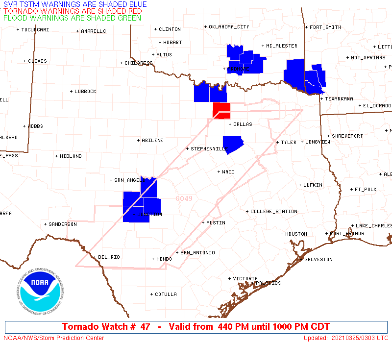
   SAW7
   WW 47 TORNADO TX 242140Z - 250300Z
   AXIS..50 STATUTE MILES NORTH AND SOUTH OF LINE..
   50NE CRS/CORSICANA TX/ - 70SSW BWD/BROWNWOOD TX/
   ..AVIATION COORDS.. 45NM N/S /53W GGG - 27NE JCT/
   HAIL SURFACE AND ALOFT..3 INCHES. WIND GUSTS..60 KNOTS.
   MAX TOPS TO 500. MEAN STORM MOTION VECTOR 24030.

   LAT...LON 31829579 30149940 31599940 33259579

   THIS IS AN APPROXIMATION TO THE WATCH AREA.  FOR A
   COMPLETE DEPICTION OF THE WATCH SEE WOUS64 KWNS
   FOR WOU7.
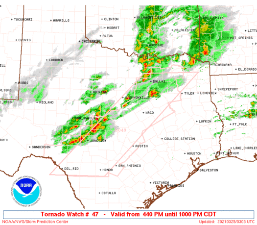
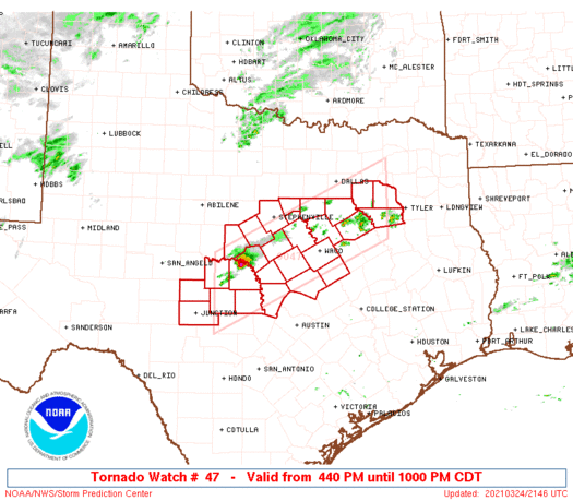
Watch 47 Status Report Messages:
STATUS REPORT #5 ON WW 47

VALID 250140Z - 250240Z

THE SEVERE WEATHER THREAT CONTINUES ACROSS THE ENTIRE WATCH AREA.

FOR ADDITIONAL INFORMATION SEE MESOSCALE DISCUSSION 245

..COOK..03/25/21

ATTN...WFO...FWD...SJT...EWX...

&&

STATUS REPORT FOR WT 47

SEVERE WEATHER THREAT CONTINUES FOR THE FOLLOWING AREAS

TXC027-035-049-053-093-099-139-143-145-193-213-217-221-251-257-
267-281-299-307-309-319-327-333-349-411-425-467-250240-

TX
.    TEXAS COUNTIES INCLUDED ARE

BELL		     BOSQUE		 BROWN
BURNET		     COMANCHE		 CORYELL
ELLIS		     ERATH		 FALLS
HAMILTON	     HENDERSON		 HILL
HOOD		     JOHNSON		 KAUFMAN
KIMBLE		     LAMPASAS		 LLANO
MCCULLOCH	     MCLENNAN		 MASON
MENARD		     MILLS		 NAVARRO
SAN SABA	     SOMERVELL		 VAN ZANDT
$$


THE WATCH STATUS MESSAGE IS FOR GUIDANCE PURPOSES ONLY.  PLEASE
REFER TO WATCH COUNTY NOTIFICATION STATEMENTS FOR OFFICIAL
INFORMATION ON COUNTIES...INDEPENDENT CITIES AND MARINE ZONES
CLEARED FROM SEVERE THUNDERSTORM AND TORNADO WATCHES.
$$

STATUS REPORT #4 ON WW 47

VALID 250040Z - 250140Z

THE SEVERE WEATHER THREAT CONTINUES ACROSS THE ENTIRE WATCH AREA.

..COOK..03/25/21

ATTN...WFO...FWD...SJT...EWX...

&&

STATUS REPORT FOR WT 47

SEVERE WEATHER THREAT CONTINUES FOR THE FOLLOWING AREAS

TXC027-035-049-053-093-099-139-143-145-193-213-217-221-251-257-
267-281-299-307-309-319-327-333-349-411-425-467-250140-

TX
.    TEXAS COUNTIES INCLUDED ARE

BELL		     BOSQUE		 BROWN
BURNET		     COMANCHE		 CORYELL
ELLIS		     ERATH		 FALLS
HAMILTON	     HENDERSON		 HILL
HOOD		     JOHNSON		 KAUFMAN
KIMBLE		     LAMPASAS		 LLANO
MCCULLOCH	     MCLENNAN		 MASON
MENARD		     MILLS		 NAVARRO
SAN SABA	     SOMERVELL		 VAN ZANDT
$$


THE WATCH STATUS MESSAGE IS FOR GUIDANCE PURPOSES ONLY.  PLEASE
REFER TO WATCH COUNTY NOTIFICATION STATEMENTS FOR OFFICIAL
INFORMATION ON COUNTIES...INDEPENDENT CITIES AND MARINE ZONES
CLEARED FROM SEVERE THUNDERSTORM AND TORNADO WATCHES.
$$

STATUS REPORT #3 ON WW 47

VALID 242330Z - 250040Z

THE SEVERE WEATHER THREAT CONTINUES ACROSS THE ENTIRE WATCH AREA.

FOR ADDITIONAL INFORMATION SEE MESOSCALE DISCUSSION 243

..COOK..03/24/21

ATTN...WFO...FWD...SJT...EWX...

&&

STATUS REPORT FOR WT 47

SEVERE WEATHER THREAT CONTINUES FOR THE FOLLOWING AREAS

TXC027-035-049-053-093-099-139-143-145-193-213-217-221-251-257-
267-281-299-307-309-319-327-333-349-411-425-467-250040-

TX
.    TEXAS COUNTIES INCLUDED ARE

BELL		     BOSQUE		 BROWN
BURNET		     COMANCHE		 CORYELL
ELLIS		     ERATH		 FALLS
HAMILTON	     HENDERSON		 HILL
HOOD		     JOHNSON		 KAUFMAN
KIMBLE		     LAMPASAS		 LLANO
MCCULLOCH	     MCLENNAN		 MASON
MENARD		     MILLS		 NAVARRO
SAN SABA	     SOMERVELL		 VAN ZANDT
$$


THE WATCH STATUS MESSAGE IS FOR GUIDANCE PURPOSES ONLY.  PLEASE
REFER TO WATCH COUNTY NOTIFICATION STATEMENTS FOR OFFICIAL
INFORMATION ON COUNTIES...INDEPENDENT CITIES AND MARINE ZONES
CLEARED FROM SEVERE THUNDERSTORM AND TORNADO WATCHES.
$$

STATUS REPORT #2 ON WW 47

VALID 242235Z - 242340Z

THE SEVERE WEATHER THREAT CONTINUES ACROSS THE ENTIRE WATCH AREA.

..COOK..03/24/21

ATTN...WFO...FWD...SJT...EWX...

&&

STATUS REPORT FOR WT 47

SEVERE WEATHER THREAT CONTINUES FOR THE FOLLOWING AREAS

TXC027-035-049-053-093-099-139-143-145-193-213-217-221-251-257-
267-281-299-307-309-319-327-333-349-411-425-467-242340-

TX
.    TEXAS COUNTIES INCLUDED ARE

BELL		     BOSQUE		 BROWN
BURNET		     COMANCHE		 CORYELL
ELLIS		     ERATH		 FALLS
HAMILTON	     HENDERSON		 HILL
HOOD		     JOHNSON		 KAUFMAN
KIMBLE		     LAMPASAS		 LLANO
MCCULLOCH	     MCLENNAN		 MASON
MENARD		     MILLS		 NAVARRO
SAN SABA	     SOMERVELL		 VAN ZANDT
$$


THE WATCH STATUS MESSAGE IS FOR GUIDANCE PURPOSES ONLY.  PLEASE
REFER TO WATCH COUNTY NOTIFICATION STATEMENTS FOR OFFICIAL
INFORMATION ON COUNTIES...INDEPENDENT CITIES AND MARINE ZONES
CLEARED FROM SEVERE THUNDERSTORM AND TORNADO WATCHES.
$$

STATUS REPORT #1 ON WW 47

VALID 242235Z - 250000Z

THE SEVERE WEATHER THREAT CONTINUES ACROSS THE ENTIRE WATCH AREA.

..SMITH..03/24/21

ATTN...WFO...FWD...SJT...EWX...

&&

STATUS REPORT FOR WT 47

SEVERE WEATHER THREAT CONTINUES FOR THE FOLLOWING AREAS

TXC027-035-049-053-093-099-139-143-145-193-213-217-221-251-257-
267-281-299-307-309-319-327-333-349-411-425-467-250000-

TX
.    TEXAS COUNTIES INCLUDED ARE

BELL		     BOSQUE		 BROWN
BURNET		     COMANCHE		 CORYELL
ELLIS		     ERATH		 FALLS
HAMILTON	     HENDERSON		 HILL
HOOD		     JOHNSON		 KAUFMAN
KIMBLE		     LAMPASAS		 LLANO
MCCULLOCH	     MCLENNAN		 MASON
MENARD		     MILLS		 NAVARRO
SAN SABA	     SOMERVELL		 VAN ZANDT
$$


THE WATCH STATUS MESSAGE IS FOR GUIDANCE PURPOSES ONLY.  PLEASE
REFER TO WATCH COUNTY NOTIFICATION STATEMENTS FOR OFFICIAL
INFORMATION ON COUNTIES...INDEPENDENT CITIES AND MARINE ZONES
CLEARED FROM SEVERE THUNDERSTORM AND TORNADO WATCHES.
$$
Note:
Click for Complete Product Text.
Tornadoes
Probability of 2 or more tornadoes
|
Mod (30%)
|
Probability of 1 or more strong (EF2-EF5) tornadoes
|
Low (10%)
|
Wind
Probability of 10 or more severe wind events
|
Mod (30%)
|
Probability of 1 or more wind events > 65 knots
|
Low (20%)
|
Hail
Probability of 10 or more severe hail events
|
Mod (60%)
|
Probability of 1 or more hailstones > 2 inches
|
Mod (60%)
|
Combined Severe Hail/Wind
Probability of 6 or more combined severe hail/wind events
|
High (80%)
|
For each watch, probabilities for particular events inside the watch
(listed above in each table) are determined by the issuing forecaster.
The "Low" category contains probability values ranging from less than 2%
to 20% (EF2-EF5 tornadoes), less than 5% to 20% (all other probabilities),
"Moderate" from 30% to 60%, and "High" from 70% to greater than 95%.
High values are bolded and lighter in color to provide awareness of
an increased threat for a particular event.


 @NWSSPC