 Note:
The expiration time in the watch graphic is amended if the watch is
replaced, cancelled or extended.
Note:
Note:
The expiration time in the watch graphic is amended if the watch is
replaced, cancelled or extended.
Note: Click for
Watch Status Reports.
SEL9
URGENT - IMMEDIATE BROADCAST REQUESTED
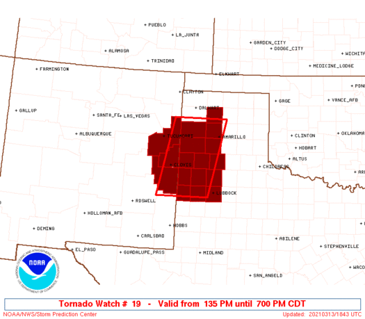
Tornado Watch Number 19...CORRECTED
NWS Storm Prediction Center Norman OK
1250 PM CST Sat Mar 13 2021
CORRECTED FOR TIME ZONE
The NWS Storm Prediction Center has issued a
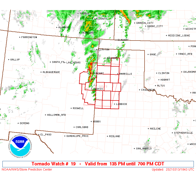
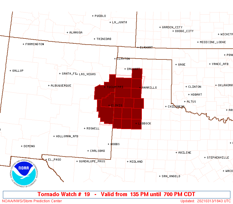
* Tornado Watch for portions of
East-central New Mexico
Northwest Texas
* Effective this Saturday afternoon and evening from 1250 PM
until 600 PM CST.
* Primary threats include...
A few tornadoes and a couple intense tornadoes possible
Scattered large hail and isolated very large hail events to 2.5
inches in diameter possible
Isolated damaging wind gusts to 70 mph possible
SUMMARY...Initial discrete supercells should develop east-northeast
from the east-central New Mexico and northwest Texas border region.
Tornado and large hail will be the primary hazards.
The tornado watch area is approximately along and 50 statute miles
east and west of a line from 50 miles northwest of Amarillo TX to 65
miles south southeast of Cannon Afb NM. For a complete depiction of
the watch see the associated watch outline update (WOUS64 KWNS
WOU9).
PRECAUTIONARY/PREPAREDNESS ACTIONS...
REMEMBER...A Tornado Watch means conditions are favorable for
tornadoes and severe thunderstorms in and close to the watch
area. Persons in these areas should be on the lookout for
threatening weather conditions and listen for later statements
and possible warnings.
&&
AVIATION...Tornadoes and a few severe thunderstorms with hail
surface and aloft to 2.5 inches. Extreme turbulence and surface wind
gusts to 60 knots. A few cumulonimbi with maximum tops to 450. Mean
storm motion vector 21045.
...Grams
 Note:
The Aviation Watch (SAW) product is an approximation to the watch area.
The actual watch is depicted by the shaded areas.
Note:
The Aviation Watch (SAW) product is an approximation to the watch area.
The actual watch is depicted by the shaded areas.
   SAW9
   WW 19 TORNADO NM TX 131835Z - 140000Z
   AXIS..50 STATUTE MILES EAST AND WEST OF LINE..
   50NW AMA/AMARILLO TX/ - 65SSE CVS/CANNON AFB NM/
   ..AVIATION COORDS.. 45NM E/W /44NW AMA - 50WSW LBB/
   HAIL SURFACE AND ALOFT..2.5 INCHES. WIND GUSTS..60 KNOTS.
   MAX TOPS TO 450. MEAN STORM MOTION VECTOR 21045.

   LAT...LON 35730146 33500202 33500376 35730324

   THIS IS AN APPROXIMATION TO THE WATCH AREA.  FOR A
   COMPLETE DEPICTION OF THE WATCH SEE WOUS64 KWNS
   FOR WOU9.
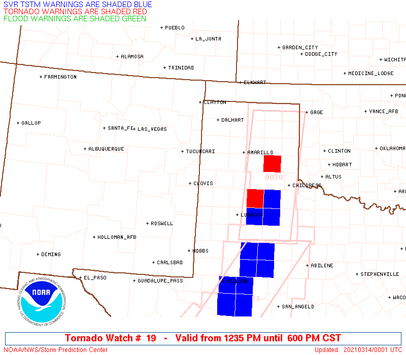
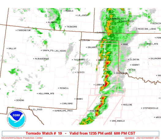
Watch 19 Status Report Messages:
STATUS REPORT #1 ON WW 19

VALID 132025Z - 132140Z

SEVERE WEATHER THREAT CONTINUES RIGHT OF A LINE FROM 55 NNE HOB
TO 20 SW DHT.

..LEITMAN..03/13/21

ATTN...WFO...ABQ...LUB...AMA...

&&

STATUS REPORT FOR WT 19

SEVERE WEATHER THREAT CONTINUES FOR THE FOLLOWING AREAS

TXC017-069-079-117-189-219-279-303-341-359-369-375-381-437-
132140-

TX
.    TEXAS COUNTIES INCLUDED ARE

BAILEY		     CASTRO		 COCHRAN
DEAF SMITH	     HALE		 HOCKLEY
LAMB		     LUBBOCK		 MOORE
OLDHAM		     PARMER		 POTTER
RANDALL 	     SWISHER
$$


THE WATCH STATUS MESSAGE IS FOR GUIDANCE PURPOSES ONLY.  PLEASE
REFER TO WATCH COUNTY NOTIFICATION STATEMENTS FOR OFFICIAL
INFORMATION ON COUNTIES...INDEPENDENT CITIES AND MARINE ZONES
CLEARED FROM SEVERE THUNDERSTORM AND TORNADO WATCHES.
$$
Note:
Click for Complete Product Text.
Tornadoes
Probability of 2 or more tornadoes
|
Mod (50%)
|
Probability of 1 or more strong (EF2-EF5) tornadoes
|
Mod (30%)
|
Wind
Probability of 10 or more severe wind events
|
Low (20%)
|
Probability of 1 or more wind events > 65 knots
|
Low (20%)
|
Hail
Probability of 10 or more severe hail events
|
Mod (50%)
|
Probability of 1 or more hailstones > 2 inches
|
Mod (50%)
|
Combined Severe Hail/Wind
Probability of 6 or more combined severe hail/wind events
|
High (70%)
|
For each watch, probabilities for particular events inside the watch
(listed above in each table) are determined by the issuing forecaster.
The "Low" category contains probability values ranging from less than 2%
to 20% (EF2-EF5 tornadoes), less than 5% to 20% (all other probabilities),
"Moderate" from 30% to 60%, and "High" from 70% to greater than 95%.
High values are bolded and lighter in color to provide awareness of
an increased threat for a particular event.


 @NWSSPC