Note:
The expiration time in the watch graphic is amended if the watch is
replaced, cancelled or extended.
Note:
Note:
The expiration time in the watch graphic is amended if the watch is
replaced, cancelled or extended.
Note: Click for
Watch Status Reports.
SEL0
URGENT - IMMEDIATE BROADCAST REQUESTED
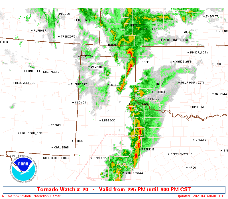
Tornado Watch Number 20
NWS Storm Prediction Center Norman OK
225 PM CST Sat Mar 13 2021
The NWS Storm Prediction Center has issued a
* Tornado Watch for portions of
Northwest Texas
* Effective this Saturday afternoon and evening from 225 PM until
900 PM CST.
* Primary threats include...
Several tornadoes and a couple intense tornadoes likely
Scattered damaging winds and isolated significant gusts to 80
mph likely
Scattered large hail and isolated very large hail events to 3
inches in diameter likely
SUMMARY...Multiple supercells and clusters are expected to evolve
northeast across the Texas Panhandle and adjacent portion of the
South Plains. Tornadoes and large hail will be most likely with
cells that able to remain mostly discrete. While the potential for
damaging winds will increase as storms become more linear this
evening.
The tornado watch area is approximately along and 45 statute miles
east and west of a line from 60 miles northeast of Borger TX to 105
miles south southwest of Childress TX. For a complete depiction of
the watch see the associated watch outline update (WOUS64 KWNS
WOU0).
PRECAUTIONARY/PREPAREDNESS ACTIONS...
REMEMBER...A Tornado Watch means conditions are favorable for
tornadoes and severe thunderstorms in and close to the watch
area. Persons in these areas should be on the lookout for
threatening weather conditions and listen for later statements
and possible warnings.
&&
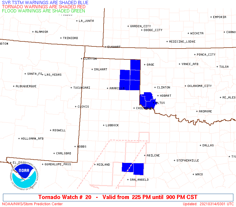
OTHER WATCH INFORMATION...CONTINUE...WW 19...
AVIATION...Tornadoes and a few severe thunderstorms with hail
surface and aloft to 3 inches. Extreme turbulence and surface wind
gusts to 70 knots. A few cumulonimbi with maximum tops to 500. Mean
storm motion vector 22040.
...Grams
 Note:
The Aviation Watch (SAW) product is an approximation to the watch area.
The actual watch is depicted by the shaded areas.
Note:
The Aviation Watch (SAW) product is an approximation to the watch area.
The actual watch is depicted by the shaded areas.
SAW0
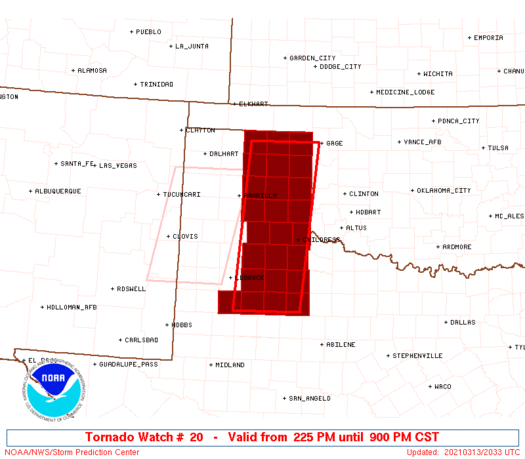
WW 20 TORNADO TX 132025Z - 140300Z
AXIS..45 STATUTE MILES EAST AND WEST OF LINE..
60NE BGD/BORGER TX/ - 105SSW CDS/CHILDRESS TX/
..AVIATION COORDS.. 40NM E/W /37W MMB - 62SE LBB/
HAIL SURFACE AND ALOFT..3 INCHES. WIND GUSTS..70 KNOTS.
MAX TOPS TO 500. MEAN STORM MOTION VECTOR 22040.
LAT...LON 36319983 33020020 33020175 36310145
THIS IS AN APPROXIMATION TO THE WATCH AREA. FOR A
COMPLETE DEPICTION OF THE WATCH SEE WOUS64 KWNS
FOR WOU0.
Watch 20 Status Report Messages:
STATUS REPORT #2 ON WW 20

VALID 140145Z - 140240Z

SEVERE WEATHER THREAT CONTINUES RIGHT OF A LINE FROM 65 NNE BGS
TO 55 E LBB TO 45 SW CDS TO 25 ENE PVW TO 35 SSE AMA TO 25 E AMA
TO 15 SE BGD TO 20 NNW BGD.

..SPC..03/14/21

ATTN...WFO...AMA...LUB...

&&

STATUS REPORT FOR WT 20

SEVERE WEATHER THREAT CONTINUES FOR THE FOLLOWING AREAS

TXC011-045-065-075-087-101-125-129-153-179-191-195-211-233-263-
269-295-345-357-393-433-483-140240-

TX
.    TEXAS COUNTIES INCLUDED ARE

ARMSTRONG	     BRISCOE		 CARSON
CHILDRESS	     COLLINGSWORTH	 COTTLE
DICKENS 	     DONLEY		 FLOYD
GRAY		     HALL		 HANSFORD
HEMPHILL	     HUTCHINSON 	 KENT
KING		     LIPSCOMB		 MOTLEY
OCHILTREE	     ROBERTS		 STONEWALL
WHEELER
$$


THE WATCH STATUS MESSAGE IS FOR GUIDANCE PURPOSES ONLY.  PLEASE
REFER TO WATCH COUNTY NOTIFICATION STATEMENTS FOR OFFICIAL
INFORMATION ON COUNTIES...INDEPENDENT CITIES AND MARINE ZONES
CLEARED FROM SEVERE THUNDERSTORM AND TORNADO WATCHES.
$$

STATUS REPORT #1 ON WW 20

VALID 132350Z - 140040Z

THE SEVERE WEATHER THREAT CONTINUES ACROSS THE ENTIRE WATCH AREA.

..SPC..03/13/21

ATTN...WFO...AMA...LUB...

&&

STATUS REPORT FOR WT 20

SEVERE WEATHER THREAT CONTINUES FOR THE FOLLOWING AREAS

TXC011-045-065-075-087-101-107-125-129-153-169-179-191-195-211-
233-263-269-295-305-345-357-393-433-483-140040-

TX
.    TEXAS COUNTIES INCLUDED ARE

ARMSTRONG	     BRISCOE		 CARSON
CHILDRESS	     COLLINGSWORTH	 COTTLE
CROSBY		     DICKENS		 DONLEY
FLOYD		     GARZA		 GRAY
HALL		     HANSFORD		 HEMPHILL
HUTCHINSON	     KENT		 KING
LIPSCOMB	     LYNN		 MOTLEY
OCHILTREE	     ROBERTS		 STONEWALL
WHEELER
$$


THE WATCH STATUS MESSAGE IS FOR GUIDANCE PURPOSES ONLY.  PLEASE
REFER TO WATCH COUNTY NOTIFICATION STATEMENTS FOR OFFICIAL
INFORMATION ON COUNTIES...INDEPENDENT CITIES AND MARINE ZONES
CLEARED FROM SEVERE THUNDERSTORM AND TORNADO WATCHES.
$$
Note:
Click for Complete Product Text.
Tornadoes
Probability of 2 or more tornadoes
|
High (80%)
|
Probability of 1 or more strong (EF2-EF5) tornadoes
|
Mod (60%)
|
Wind
Probability of 10 or more severe wind events
|
Mod (60%)
|
Probability of 1 or more wind events > 65 knots
|
Mod (60%)
|
Hail
Probability of 10 or more severe hail events
|
Mod (60%)
|
Probability of 1 or more hailstones > 2 inches
|
Mod (60%)
|
Combined Severe Hail/Wind
Probability of 6 or more combined severe hail/wind events
|
High (>95%)
|
For each watch, probabilities for particular events inside the watch
(listed above in each table) are determined by the issuing forecaster.
The "Low" category contains probability values ranging from less than 2%
to 20% (EF2-EF5 tornadoes), less than 5% to 20% (all other probabilities),
"Moderate" from 30% to 60%, and "High" from 70% to greater than 95%.
High values are bolded and lighter in color to provide awareness of
an increased threat for a particular event.


 @NWSSPC