 Note:
The expiration time in the watch graphic is amended if the watch is
replaced, cancelled or extended.
Note:
Note:
The expiration time in the watch graphic is amended if the watch is
replaced, cancelled or extended.
Note: Click for
Watch Status Reports.
SEL8
URGENT - IMMEDIATE BROADCAST REQUESTED
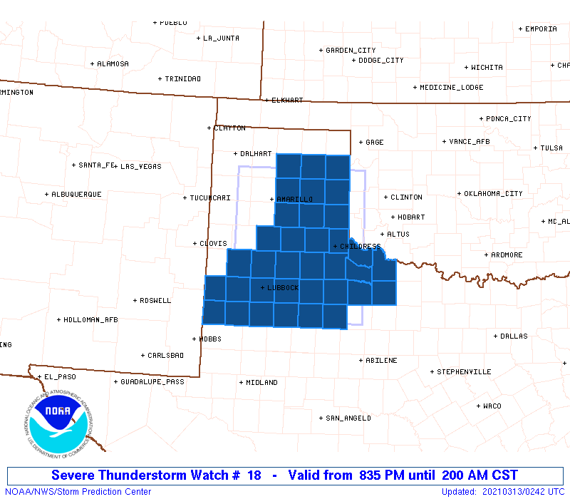
Severe Thunderstorm Watch Number 18
NWS Storm Prediction Center Norman OK
835 PM CST Fri Mar 12 2021
The NWS Storm Prediction Center has issued a
* Severe Thunderstorm Watch for portions of
West and Northwest Texas
* Effective this Friday night and Saturday morning from 835 PM
until 200 AM CST.
* Primary threats include...
Scattered large hail and isolated very large hail events to 2
inches in diameter possible
Scattered damaging wind gusts to 70 mph possible
A tornado or two possible
SUMMARY...Multiple cluster of intense thunderstorms are affecting
the watch area. Storms are likely to re-develop in the next few
hours, maintaining a risk of a few severe storms capable of large
hail and damaging wind gusts.
The severe thunderstorm watch area is approximately along and 95
statute miles north and south of a line from 45 miles west northwest
of Plainview TX to 35 miles east of Childress TX. For a complete
depiction of the watch see the associated watch outline update
(WOUS64 KWNS WOU8).
PRECAUTIONARY/PREPAREDNESS ACTIONS...
REMEMBER...A Severe Thunderstorm Watch means conditions are
favorable for severe thunderstorms in and close to the watch area.
Persons in these areas should be on the lookout for threatening
weather conditions and listen for later statements and possible
warnings. Severe thunderstorms can and occasionally do produce
tornadoes.
&&
OTHER WATCH INFORMATION...CONTINUE...WW 17...
AVIATION...A few severe thunderstorms with hail surface and aloft to
2 inches. Extreme turbulence and surface wind gusts to 60 knots. A
few cumulonimbi with maximum tops to 450. Mean storm motion vector
24035.
...Hart
   SEL8

   URGENT - IMMEDIATE BROADCAST REQUESTED
   Severe Thunderstorm Watch Number 18
   NWS Storm Prediction Center Norman OK
   835 PM CST Fri Mar 12 2021

   The NWS Storm Prediction Center has issued a

   * Severe Thunderstorm Watch for portions of
     West and Northwest Texas

   * Effective this Friday night and Saturday morning from 835 PM
     until 200 AM CST.

   * Primary threats include...
     Scattered large hail and isolated very large hail events to 2
       inches in diameter possible
     Scattered damaging wind gusts to 70 mph possible
     A tornado or two possible

   SUMMARY...Multiple cluster of intense thunderstorms are affecting
   the watch area.  Storms are likely to re-develop in the next few
   hours, maintaining a risk of a few severe storms capable of large
   hail and damaging wind gusts.

   The severe thunderstorm watch area is approximately along and 95
   statute miles north and south of a line from 45 miles west northwest
   of Plainview TX to 35 miles east of Childress TX. For a complete
   depiction of the watch see the associated watch outline update
   (WOUS64 KWNS WOU8).

   PRECAUTIONARY/PREPAREDNESS ACTIONS...

   REMEMBER...A Severe Thunderstorm Watch means conditions are
   favorable for severe thunderstorms in and close to the watch area.
   Persons in these areas should be on the lookout for threatening
   weather conditions and listen for later statements and possible
   warnings. Severe thunderstorms can and occasionally do produce
   tornadoes.

   &&

   OTHER WATCH INFORMATION...CONTINUE...WW 17...

   AVIATION...A few severe thunderstorms with hail surface and aloft to
   2 inches. Extreme turbulence and surface wind gusts to 60 knots. A
   few cumulonimbi with maximum tops to 450. Mean storm motion vector
   24035.

   ...Hart
 Note:
The Aviation Watch (SAW) product is an approximation to the watch area.
The actual watch is depicted by the shaded areas.
Note:
The Aviation Watch (SAW) product is an approximation to the watch area.
The actual watch is depicted by the shaded areas.
SAW8
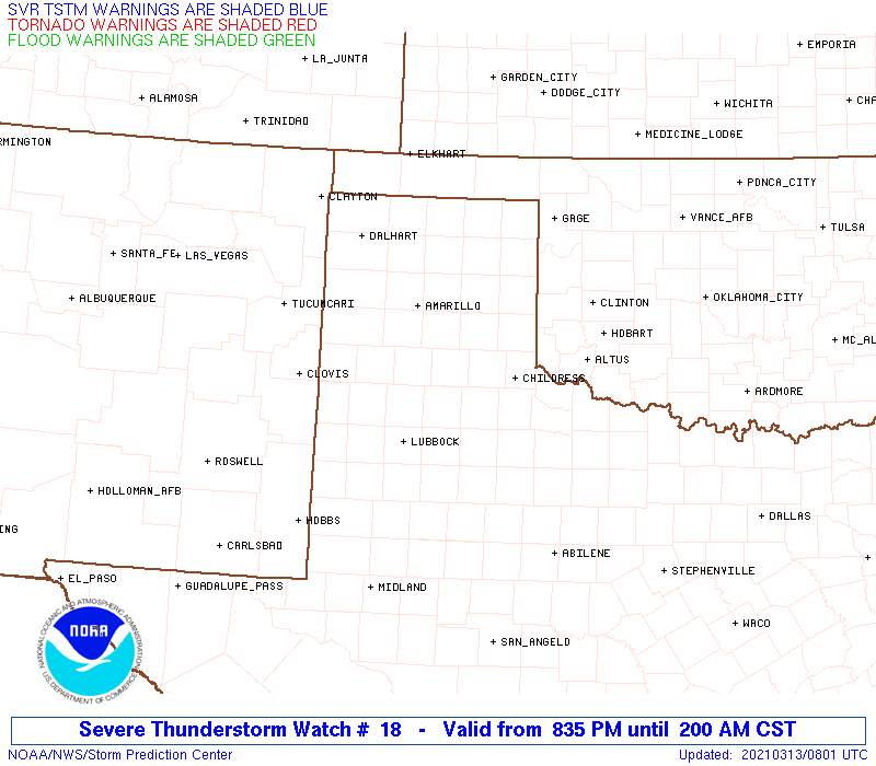
WW 18 SEVERE TSTM TX 130235Z - 130800Z
AXIS..95 STATUTE MILES NORTH AND SOUTH OF LINE..
45WNW PVW/PLAINVIEW TX/ - 35E CDS/CHILDRESS TX/
..AVIATION COORDS.. 80NM N/S /20ESE TXO - 31E CDS/
HAIL SURFACE AND ALOFT..2 INCHES. WIND GUSTS..60 KNOTS.
MAX TOPS TO 450. MEAN STORM MOTION VECTOR 24035.
LAT...LON 35790245 35809967 33059967 33040245
THIS IS AN APPROXIMATION TO THE WATCH AREA. FOR A
COMPLETE DEPICTION OF THE WATCH SEE WOUS64 KWNS
FOR WOU8.
Watch 18 Status Report Messages:
STATUS REPORT #2 ON WW 18

VALID 130745Z - 130800Z

SEVERE WEATHER THREAT CONTINUES RIGHT OF A LINE FROM 25 SW SPS TO
20 SE CDS TO 25 NE CDS TO 10 WNW LTS.

WW 18 WILL BE ALLOWED TO EXPIRE AT 130800Z.

FOR ADDITIONAL INFORMATION SEE MESOSCALE DISCUSSION 161

..GLEASON..03/13/21

ATTN...WFO...AMA...OUN...LUB...

&&

STATUS REPORT FOR WS 18

SEVERE WEATHER THREAT CONTINUES FOR THE FOLLOWING AREAS

TXC197-487-130800-

TX
.    TEXAS COUNTIES INCLUDED ARE

HARDEMAN	     WILBARGER
$$


THE WATCH STATUS MESSAGE IS FOR GUIDANCE PURPOSES ONLY.  PLEASE
REFER TO WATCH COUNTY NOTIFICATION STATEMENTS FOR OFFICIAL
INFORMATION ON COUNTIES...INDEPENDENT CITIES AND MARINE ZONES
CLEARED FROM SEVERE THUNDERSTORM AND TORNADO WATCHES.
$$

STATUS REPORT #1 ON WW 18

VALID 130635Z - 130740Z

SEVERE WEATHER THREAT CONTINUES RIGHT OF A LINE FROM 50 N BGS TO
30 E PVW TO 20 W CDS TO 30 NW CDS TO 15 WNW LTS.

FOR ADDITIONAL INFORMATION SEE MESOSCALE DISCUSSION 160

..GLEASON..03/13/21

ATTN...WFO...AMA...OUN...LUB...

&&

STATUS REPORT FOR WS 18

SEVERE WEATHER THREAT CONTINUES FOR THE FOLLOWING AREAS

TXC023-075-101-107-125-153-155-169-191-197-263-269-275-345-433-
487-130740-

TX
.    TEXAS COUNTIES INCLUDED ARE

BAYLOR		     CHILDRESS		 COTTLE
CROSBY		     DICKENS		 FLOYD
FOARD		     GARZA		 HALL
HARDEMAN	     KENT		 KING
KNOX		     MOTLEY		 STONEWALL
WILBARGER
$$


THE WATCH STATUS MESSAGE IS FOR GUIDANCE PURPOSES ONLY.  PLEASE
REFER TO WATCH COUNTY NOTIFICATION STATEMENTS FOR OFFICIAL
INFORMATION ON COUNTIES...INDEPENDENT CITIES AND MARINE ZONES
CLEARED FROM SEVERE THUNDERSTORM AND TORNADO WATCHES.
$$
Note:
Click for Complete Product Text.
Tornadoes
Probability of 2 or more tornadoes
|
Low (20%)
|
Probability of 1 or more strong (EF2-EF5) tornadoes
|
Low (5%)
|
Wind
Probability of 10 or more severe wind events
|
Mod (40%)
|
Probability of 1 or more wind events > 65 knots
|
Low (20%)
|
Hail
Probability of 10 or more severe hail events
|
Mod (50%)
|
Probability of 1 or more hailstones > 2 inches
|
Mod (40%)
|
Combined Severe Hail/Wind
Probability of 6 or more combined severe hail/wind events
|
High (80%)
|
For each watch, probabilities for particular events inside the watch
(listed above in each table) are determined by the issuing forecaster.
The "Low" category contains probability values ranging from less than 2%
to 20% (EF2-EF5 tornadoes), less than 5% to 20% (all other probabilities),
"Moderate" from 30% to 60%, and "High" from 70% to greater than 95%.
High values are bolded and lighter in color to provide awareness of
an increased threat for a particular event.


 @NWSSPC