Note:
The expiration time in the watch graphic is amended if the watch is
replaced, cancelled or extended.
Note:
Note:
The expiration time in the watch graphic is amended if the watch is
replaced, cancelled or extended.
Note: Click for
Watch Status Reports.
SEL1
URGENT - IMMEDIATE BROADCAST REQUESTED
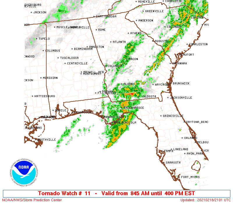
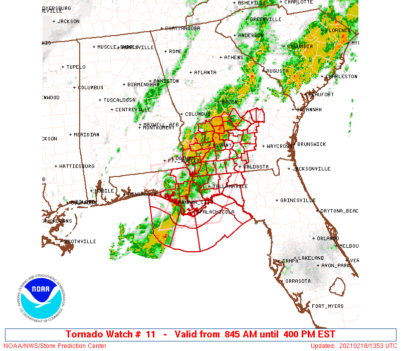
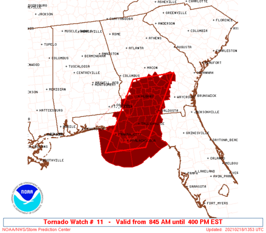
Tornado Watch Number 11
NWS Storm Prediction Center Norman OK
845 AM EST Thu Feb 18 2021
The NWS Storm Prediction Center has issued a
* Tornado Watch for portions of
Florida Panhandle
Southern Georgia
Coastal Waters
* Effective this Thursday morning and afternoon from 845 AM until
400 PM EST.
* Primary threats include...
A couple tornadoes possible
Isolated damaging wind gusts to 70 mph possible
SUMMARY...Thunderstorms are forecast to intensify today with some of
the stronger storms potentially capable of an isolated risk for
damaging gusts and possibly a couple of tornadoes.
The tornado watch area is approximately along and 60 statute miles
east and west of a line from 75 miles northeast of Albany GA to 30
miles south southwest of Apalachicola FL. For a complete depiction
of the watch see the associated watch outline update (WOUS64 KWNS
WOU1).
PRECAUTIONARY/PREPAREDNESS ACTIONS...
REMEMBER...A Tornado Watch means conditions are favorable for
tornadoes and severe thunderstorms in and close to the watch
area. Persons in these areas should be on the lookout for
threatening weather conditions and listen for later statements
and possible warnings.
&&
OTHER WATCH INFORMATION...CONTINUE...WW 10...
AVIATION...Tornadoes and a few severe thunderstorms with hail
surface and aloft to 1 inch. Extreme turbulence and surface wind
gusts to 60 knots. A few cumulonimbi with maximum tops to 450. Mean
storm motion vector 23030.
...Smith/Edwards
 Note:
The Aviation Watch (SAW) product is an approximation to the watch area.
The actual watch is depicted by the shaded areas.
Note:
The Aviation Watch (SAW) product is an approximation to the watch area.
The actual watch is depicted by the shaded areas.
   SAW1
   WW 11 TORNADO FL GA CW 181345Z - 182100Z
   AXIS..60 STATUTE MILES EAST AND WEST OF LINE..
   75NE ABY/ALBANY GA/ - 30SSW AAF/APALACHICOLA FL/
   ..AVIATION COORDS.. 50NM E/W /30SE MCN - 86SSW TLH/
   HAIL SURFACE AND ALOFT..1 INCH. WIND GUSTS..60 KNOTS.
   MAX TOPS TO 450. MEAN STORM MOTION VECTOR 23030.

   LAT...LON 32298226 29338422 29338622 32298432

   THIS IS AN APPROXIMATION TO THE WATCH AREA.  FOR A
   COMPLETE DEPICTION OF THE WATCH SEE WOUS64 KWNS
   FOR WOU1.
Watch 11 Status Report Messages:
STATUS REPORT #5 ON WW 11

VALID 182020Z - 182140Z

SEVERE WEATHER THREAT CONTINUES RIGHT OF A LINE FROM 30 S AAF TO
20 S ABY TO 50 ENE ABY TO 30 SSW VDI.

FOR ADDITIONAL INFORMATION SEE MESOSCALE DISCUSSION 123

..DIAL..02/18/21

ATTN...WFO...TAE...JAX...FFC...

&&

STATUS REPORT FOR WT 11

SEVERE WEATHER THREAT CONTINUES FOR THE FOLLOWING AREAS

FLC065-073-079-123-129-182140-

FL
.    FLORIDA COUNTIES INCLUDED ARE

JEFFERSON	     LEON		 MADISON
TAYLOR		     WAKULLA
$$


GAC019-027-071-075-131-155-173-185-275-277-182140-

GA
.    GEORGIA COUNTIES INCLUDED ARE

BERRIEN 	     BROOKS		 COLQUITT
COOK		     GRADY		 IRWIN
LANIER		     LOWNDES		 THOMAS
TIFT
$$


GMZ730-755-765-775-182140-

CW

.    ADJACENT COASTAL WATERS INCLUDED ARE

APALACHEE BAY OR COASTAL WATERS FROM KEATON BEACH TO OCHLOCKONEE
RIVER FL OUT TO 20 NM

COASTAL WATERS FROM  OCHLOCKONEE RIVER TO APALACHICOLA FL OUT TO
20 NM

COASTAL WATERS FROM  SUWANNEE RIVER TO KEATON BEACH OUT 20 NM

WATERS FROM SUWANNEE RIVER TO APALACHICOLA FL FROM 20 TO 60 NM

$$
THE WATCH STATUS MESSAGE IS FOR GUIDANCE PURPOSES ONLY.  PLEASE
REFER TO WATCH COUNTY NOTIFICATION STATEMENTS FOR OFFICIAL
INFORMATION ON COUNTIES...INDEPENDENT CITIES AND MARINE ZONES
CLEARED FROM SEVERE THUNDERSTORM AND TORNADO WATCHES.
$$

STATUS REPORT #4 ON WW 11

VALID 181820Z - 181940Z

SEVERE WEATHER THREAT CONTINUES RIGHT OF A LINE FROM 30 SSW AAF
TO 30 SSW ABY TO 50 ENE ABY TO 30 SSW VDI.

..DIAL..02/18/21

ATTN...WFO...TAE...JAX...FFC...

&&

STATUS REPORT FOR WT 11

SEVERE WEATHER THREAT CONTINUES FOR THE FOLLOWING AREAS

FLC037-039-065-073-077-079-123-129-181940-

FL
.    FLORIDA COUNTIES INCLUDED ARE

FRANKLIN	     GADSDEN		 JEFFERSON
LEON		     LIBERTY		 MADISON
TAYLOR		     WAKULLA
$$


GAC003-017-019-027-069-071-075-131-155-161-173-185-205-275-277-
321-181940-

GA
.    GEORGIA COUNTIES INCLUDED ARE

ATKINSON	     BEN HILL		 BERRIEN
BROOKS		     COFFEE		 COLQUITT
COOK		     GRADY		 IRWIN
JEFF DAVIS	     LANIER		 LOWNDES
MITCHELL	     THOMAS		 TIFT
WORTH
$$


GMZ730-755-765-772-775-181940-

CW

.    ADJACENT COASTAL WATERS INCLUDED ARE

APALACHEE BAY OR COASTAL WATERS FROM KEATON BEACH TO OCHLOCKONEE
RIVER FL OUT TO 20 NM

COASTAL WATERS FROM  OCHLOCKONEE RIVER TO APALACHICOLA FL OUT TO
20 NM

COASTAL WATERS FROM  SUWANNEE RIVER TO KEATON BEACH OUT 20 NM

WATERS FROM MEXICO BEACH TO APALACHICOLA FL FROM 20 TO 60 NM

WATERS FROM SUWANNEE RIVER TO APALACHICOLA FL FROM 20 TO 60 NM

$$
THE WATCH STATUS MESSAGE IS FOR GUIDANCE PURPOSES ONLY.  PLEASE
REFER TO WATCH COUNTY NOTIFICATION STATEMENTS FOR OFFICIAL
INFORMATION ON COUNTIES...INDEPENDENT CITIES AND MARINE ZONES
CLEARED FROM SEVERE THUNDERSTORM AND TORNADO WATCHES.
$$

STATUS REPORT #3 ON WW 11

VALID 181710Z - 181840Z

SEVERE WEATHER THREAT CONTINUES RIGHT OF A LINE FROM 55 WSW AAF
TO 35 NNE MAI TO 40 SE MCN.

FOR ADDITIONAL INFORMATION SEE MESOSCALE DISCUSSION 121

..DIAL..02/18/21

ATTN...WFO...TAE...JAX...FFC...

&&

STATUS REPORT FOR WT 11

SEVERE WEATHER THREAT CONTINUES FOR THE FOLLOWING AREAS

FLC013-037-039-045-065-073-077-079-123-129-181840-

FL
.    FLORIDA COUNTIES INCLUDED ARE

CALHOUN 	     FRANKLIN		 GADSDEN
GULF		     JEFFERSON		 LEON
LIBERTY 	     MADISON		 TAYLOR
WAKULLA
$$


GAC003-007-017-019-027-069-071-075-081-087-091-095-131-155-161-
173-185-201-205-209-253-271-275-277-279-287-309-315-321-
181840-

GA
.    GEORGIA COUNTIES INCLUDED ARE

ATKINSON	     BAKER		 BEN HILL
BERRIEN 	     BROOKS		 COFFEE
COLQUITT	     COOK		 CRISP
DECATUR 	     DODGE		 DOUGHERTY
GRADY		     IRWIN		 JEFF DAVIS
LANIER		     LOWNDES		 MILLER
MITCHELL	     MONTGOMERY 	 SEMINOLE
TELFAIR 	     THOMAS		 TIFT
TOOMBS		     TURNER		 WHEELER
WILCOX		     WORTH
$$


GMZ730-752-755-765-772-775-181840-

CW

.    ADJACENT COASTAL WATERS INCLUDED ARE

APALACHEE BAY OR COASTAL WATERS FROM KEATON BEACH TO OCHLOCKONEE
RIVER FL OUT TO 20 NM

COASTAL WATERS FROM MEXICO BEACH TO APALACHICOLA OUT 20 NM

COASTAL WATERS FROM  OCHLOCKONEE RIVER TO APALACHICOLA FL OUT TO
20 NM

COASTAL WATERS FROM  SUWANNEE RIVER TO KEATON BEACH OUT 20 NM

WATERS FROM MEXICO BEACH TO APALACHICOLA FL FROM 20 TO 60 NM

WATERS FROM SUWANNEE RIVER TO APALACHICOLA FL FROM 20 TO 60 NM

$$
THE WATCH STATUS MESSAGE IS FOR GUIDANCE PURPOSES ONLY.  PLEASE
REFER TO WATCH COUNTY NOTIFICATION STATEMENTS FOR OFFICIAL
INFORMATION ON COUNTIES...INDEPENDENT CITIES AND MARINE ZONES
CLEARED FROM SEVERE THUNDERSTORM AND TORNADO WATCHES.
$$

STATUS REPORT #2 ON WW 11

VALID 181600Z - 181740Z

SEVERE WEATHER THREAT CONTINUES RIGHT OF A LINE FROM 10 N MAI TO
15 WNW ABY TO 30 NNE ABY TO 35 SE MCN.

..DIAL..02/18/21

ATTN...WFO...TAE...JAX...FFC...

&&

STATUS REPORT FOR WT 11

SEVERE WEATHER THREAT CONTINUES FOR THE FOLLOWING AREAS

FLC005-013-037-039-045-063-065-073-077-079-123-129-181740-

FL
.    FLORIDA COUNTIES INCLUDED ARE

BAY		     CALHOUN		 FRANKLIN
GADSDEN 	     GULF		 JACKSON
JEFFERSON	     LEON		 LIBERTY
MADISON 	     TAYLOR		 WAKULLA
$$


GAC003-007-017-019-027-069-071-075-081-087-091-095-131-155-161-
173-185-201-205-209-253-271-275-277-279-287-309-315-321-
181740-

GA
.    GEORGIA COUNTIES INCLUDED ARE

ATKINSON	     BAKER		 BEN HILL
BERRIEN 	     BROOKS		 COFFEE
COLQUITT	     COOK		 CRISP
DECATUR 	     DODGE		 DOUGHERTY
GRADY		     IRWIN		 JEFF DAVIS
LANIER		     LOWNDES		 MILLER
MITCHELL	     MONTGOMERY 	 SEMINOLE
TELFAIR 	     THOMAS		 TIFT
TOOMBS		     TURNER		 WHEELER
WILCOX		     WORTH
$$


GMZ730-750-752-755-765-770-772-775-181740-

CW

.    ADJACENT COASTAL WATERS INCLUDED ARE

APALACHEE BAY OR COASTAL WATERS FROM KEATON BEACH TO OCHLOCKONEE
RIVER FL OUT TO 20 NM

COASTAL WATERS FROM OKALOOSA-WALTON COUNTY LINE TO MEXICO BEACH
OUT 20 NM

COASTAL WATERS FROM MEXICO BEACH TO APALACHICOLA OUT 20 NM

COASTAL WATERS FROM  OCHLOCKONEE RIVER TO APALACHICOLA FL OUT TO
20 NM

COASTAL WATERS FROM  SUWANNEE RIVER TO KEATON BEACH OUT 20 NM

WATERS FROM OKALOOSA-WALTON COUNTY LINE TO MEXICO BEACH FROM 20
TO 60 NM

WATERS FROM MEXICO BEACH TO APALACHICOLA FL FROM 20 TO 60 NM

WATERS FROM SUWANNEE RIVER TO APALACHICOLA FL FROM 20 TO 60 NM

$$
THE WATCH STATUS MESSAGE IS FOR GUIDANCE PURPOSES ONLY.  PLEASE
REFER TO WATCH COUNTY NOTIFICATION STATEMENTS FOR OFFICIAL
INFORMATION ON COUNTIES...INDEPENDENT CITIES AND MARINE ZONES
CLEARED FROM SEVERE THUNDERSTORM AND TORNADO WATCHES.
$$

STATUS REPORT #1 ON WW 11

VALID 181505Z - 181640Z

THE SEVERE WEATHER THREAT CONTINUES ACROSS THE ENTIRE WATCH AREA.

..DIAL..02/18/21

ATTN...WFO...TAE...JAX...FFC...

&&

STATUS REPORT FOR WT 11

SEVERE WEATHER THREAT CONTINUES FOR THE FOLLOWING AREAS

FLC005-013-037-039-045-063-065-073-077-079-123-129-181640-

FL
.    FLORIDA COUNTIES INCLUDED ARE

BAY		     CALHOUN		 FRANKLIN
GADSDEN 	     GULF		 JACKSON
JEFFERSON	     LEON		 LIBERTY
MADISON 	     TAYLOR		 WAKULLA
$$


GAC003-007-017-019-027-037-069-071-075-081-087-091-093-095-099-
131-155-161-173-177-185-201-205-209-235-253-261-271-273-275-277-
279-287-309-315-321-181640-

GA
.    GEORGIA COUNTIES INCLUDED ARE

ATKINSON	     BAKER		 BEN HILL
BERRIEN 	     BROOKS		 CALHOUN
COFFEE		     COLQUITT		 COOK
CRISP		     DECATUR		 DODGE
DOOLY		     DOUGHERTY		 EARLY
GRADY		     IRWIN		 JEFF DAVIS
LANIER		     LEE		 LOWNDES
MILLER		     MITCHELL		 MONTGOMERY
PULASKI 	     SEMINOLE		 SUMTER
TELFAIR 	     TERRELL		 THOMAS
TIFT		     TOOMBS		 TURNER
WHEELER 	     WILCOX		 WORTH
$$


GMZ730-750-752-755-765-770-772-775-181640-

CW

.    ADJACENT COASTAL WATERS INCLUDED ARE

APALACHEE BAY OR COASTAL WATERS FROM KEATON BEACH TO OCHLOCKONEE
RIVER FL OUT TO 20 NM

COASTAL WATERS FROM OKALOOSA-WALTON COUNTY LINE TO MEXICO BEACH
OUT 20 NM

COASTAL WATERS FROM MEXICO BEACH TO APALACHICOLA OUT 20 NM

COASTAL WATERS FROM  OCHLOCKONEE RIVER TO APALACHICOLA FL OUT TO
20 NM

COASTAL WATERS FROM  SUWANNEE RIVER TO KEATON BEACH OUT 20 NM

WATERS FROM OKALOOSA-WALTON COUNTY LINE TO MEXICO BEACH FROM 20
TO 60 NM

WATERS FROM MEXICO BEACH TO APALACHICOLA FL FROM 20 TO 60 NM

WATERS FROM SUWANNEE RIVER TO APALACHICOLA FL FROM 20 TO 60 NM

$$
THE WATCH STATUS MESSAGE IS FOR GUIDANCE PURPOSES ONLY.  PLEASE
REFER TO WATCH COUNTY NOTIFICATION STATEMENTS FOR OFFICIAL
INFORMATION ON COUNTIES...INDEPENDENT CITIES AND MARINE ZONES
CLEARED FROM SEVERE THUNDERSTORM AND TORNADO WATCHES.
$$
Note:
Click for Complete Product Text.
Tornadoes
Probability of 2 or more tornadoes
|
Mod (40%)
|
Probability of 1 or more strong (EF2-EF5) tornadoes
|
Low (20%)
|
Wind
Probability of 10 or more severe wind events
|
Low (20%)
|
Probability of 1 or more wind events > 65 knots
|
Low (10%)
|
Hail
Probability of 10 or more severe hail events
|
Low (<5%)
|
Probability of 1 or more hailstones > 2 inches
|
Low (<5%)
|
Combined Severe Hail/Wind
Probability of 6 or more combined severe hail/wind events
|
Mod (30%)
|
For each watch, probabilities for particular events inside the watch
(listed above in each table) are determined by the issuing forecaster.
The "Low" category contains probability values ranging from less than 2%
to 20% (EF2-EF5 tornadoes), less than 5% to 20% (all other probabilities),
"Moderate" from 30% to 60%, and "High" from 70% to greater than 95%.
High values are bolded and lighter in color to provide awareness of
an increased threat for a particular event.


 @NWSSPC