 Note:
The expiration time in the watch graphic is amended if the watch is
replaced, cancelled or extended.
Note:
Note:
The expiration time in the watch graphic is amended if the watch is
replaced, cancelled or extended.
Note: Click for
Watch Status Reports.
SEL0
URGENT - IMMEDIATE BROADCAST REQUESTED
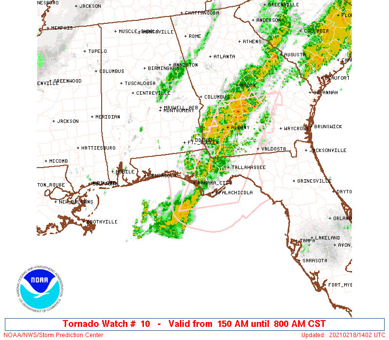
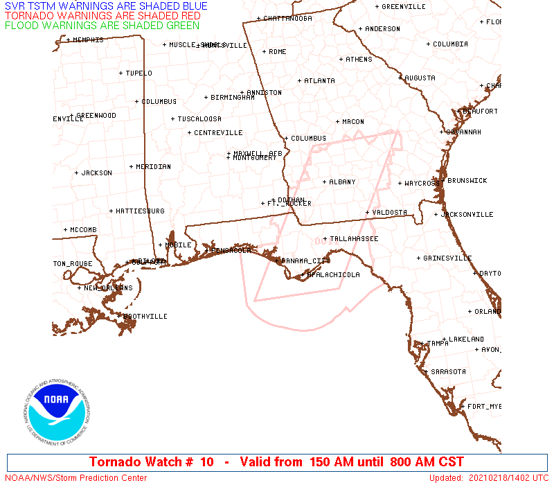
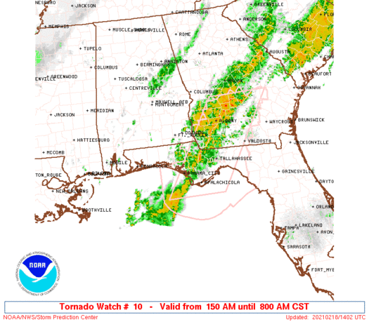
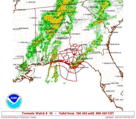
Tornado Watch Number 10
NWS Storm Prediction Center Norman OK
150 AM CST Thu Feb 18 2021
The NWS Storm Prediction Center has issued a
* Tornado Watch for portions of
Extreme southeastern Alabama
Florida Panhandle
Southwestern Georgia
Coastal Waters
* Effective this Thursday morning from 150 AM until 800 AM CST.
* Primary threats include...
A couple tornadoes possible
Isolated damaging wind gusts to 70 mph possible
SUMMARY...A severe-thunderstorm threat, including damaging gusts and
a couple tornadoes possible, will spread inland across the watch
area near and south of a warm front, through early morning.
The tornado watch area is approximately along and 55 statute miles
either side of a line from 25 miles southwest of Panama City FL to
50 miles north of Tallahassee FL. For a complete depiction of the
watch see the associated watch outline update (WOUS64 KWNS WOU0).
PRECAUTIONARY/PREPAREDNESS ACTIONS...
REMEMBER...A Tornado Watch means conditions are favorable for
tornadoes and severe thunderstorms in and close to the watch
area. Persons in these areas should be on the lookout for
threatening weather conditions and listen for later statements
and possible warnings.
&&
AVIATION...Tornadoes and a few severe thunderstorms with hail
surface and aloft to 1 inch. Extreme turbulence and surface wind
gusts to 60 knots. A few cumulonimbi with maximum tops to 450. Mean
storm motion vector 23030.
...Edwards
   SEL0

   URGENT - IMMEDIATE BROADCAST REQUESTED
   Tornado Watch Number 10
   NWS Storm Prediction Center Norman OK
   150 AM CST Thu Feb 18 2021

   The NWS Storm Prediction Center has issued a

   * Tornado Watch for portions of
     Extreme southeastern Alabama
     Florida Panhandle
     Southwestern Georgia
     Coastal Waters

   * Effective this Thursday morning from 150 AM until 800 AM CST.

   * Primary threats include...
     A couple tornadoes possible
     Isolated damaging wind gusts to 70 mph possible

   SUMMARY...A severe-thunderstorm threat, including damaging gusts and
   a couple tornadoes possible, will spread inland across the watch
   area near and south of a warm front, through early morning.

   The tornado watch area is approximately along and 55 statute miles
   either side of a line from 25 miles southwest of Panama City FL to
   50 miles north of Tallahassee FL. For a complete depiction of the
   watch see the associated watch outline update (WOUS64 KWNS WOU0).

   PRECAUTIONARY/PREPAREDNESS ACTIONS...

   REMEMBER...A Tornado Watch means conditions are favorable for
   tornadoes and severe thunderstorms in and close to the watch
   area. Persons in these areas should be on the lookout for
   threatening weather conditions and listen for later statements
   and possible warnings.

   &&

   AVIATION...Tornadoes and a few severe thunderstorms with hail
   surface and aloft to 1 inch. Extreme turbulence and surface wind
   gusts to 60 knots. A few cumulonimbi with maximum tops to 450. Mean
   storm motion vector 23030.

   ...Edwards
 Note:
The Aviation Watch (SAW) product is an approximation to the watch area.
The actual watch is depicted by the shaded areas.
Note:
The Aviation Watch (SAW) product is an approximation to the watch area.
The actual watch is depicted by the shaded areas.
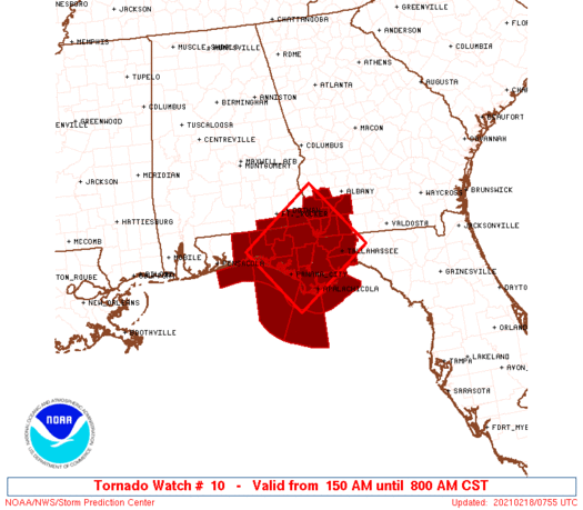
   SAW0
   WW 10 TORNADO AL FL GA CW 180750Z - 181400Z
   AXIS..55 STATUTE MILES EITHER SIDE OF LINE..
   25SW PFN/PANAMA CITY FL/ - 50N TLH/TALLAHASSEE FL/
   ..AVIATION COORDS.. 50NM EITHER SIDE /64SE CEW - 32S PZD/
   HAIL SURFACE AND ALOFT..1 INCH. WIND GUSTS..60 KNOTS.
   MAX TOPS TO 450. MEAN STORM MOTION VECTOR 23030.

   LAT...LON 30638649 31798487 30468384 29308547

   THIS IS AN APPROXIMATION TO THE WATCH AREA.  FOR A
   COMPLETE DEPICTION OF THE WATCH SEE WOUS64 KWNS
   FOR WOU0.
Watch 10 Status Report Messages:
STATUS REPORT #4 ON WW 10

VALID 181205Z - 181300Z

SEVERE WEATHER THREAT CONTINUES RIGHT OF A LINE FROM 20 WSW PFN
TO 30 WSW DHN.

FOR ADDITIONAL INFORMATION SEE MESOSCALE DISCUSSION 116

..SMITH..02/18/21

ATTN...WFO...TAE...MOB...

&&

STATUS REPORT FOR WT 10

SEVERE WEATHER THREAT CONTINUES FOR THE FOLLOWING AREAS

ALC061-069-181300-

AL
.    ALABAMA COUNTIES INCLUDED ARE

GENEVA		     HOUSTON
$$


FLC005-013-037-039-045-059-063-073-077-129-133-181300-

FL
.    FLORIDA COUNTIES INCLUDED ARE

BAY		     CALHOUN		 FRANKLIN
GADSDEN 	     GULF		 HOLMES
JACKSON 	     LEON		 LIBERTY
WAKULLA 	     WASHINGTON
$$


GAC007-037-087-099-131-201-205-253-181300-

GA
.    GEORGIA COUNTIES INCLUDED ARE

BAKER		     CALHOUN		 DECATUR
EARLY		     GRADY		 MILLER
MITCHELL	     SEMINOLE
$$


GMZ750-752-755-770-772-181300-

CW

.    ADJACENT COASTAL WATERS INCLUDED ARE

COASTAL WATERS FROM OKALOOSA-WALTON COUNTY LINE TO MEXICO BEACH
OUT 20 NM

COASTAL WATERS FROM MEXICO BEACH TO APALACHICOLA OUT 20 NM

COASTAL WATERS FROM  OCHLOCKONEE RIVER TO APALACHICOLA FL OUT TO
20 NM

WATERS FROM OKALOOSA-WALTON COUNTY LINE TO MEXICO BEACH FROM 20
TO 60 NM

WATERS FROM MEXICO BEACH TO APALACHICOLA FL FROM 20 TO 60 NM

$$
THE WATCH STATUS MESSAGE IS FOR GUIDANCE PURPOSES ONLY.  PLEASE
REFER TO WATCH COUNTY NOTIFICATION STATEMENTS FOR OFFICIAL
INFORMATION ON COUNTIES...INDEPENDENT CITIES AND MARINE ZONES
CLEARED FROM SEVERE THUNDERSTORM AND TORNADO WATCHES.
$$

STATUS REPORT #3 ON WW 10

VALID 181105Z - 181200Z

SEVERE WEATHER THREAT CONTINUES RIGHT OF A LINE FROM 35 W PFN TO
25 SW DHN.

FOR ADDITIONAL INFORMATION SEE MESOSCALE DISCUSSION 116

..SMITH..02/18/21

ATTN...WFO...TAE...MOB...

&&

STATUS REPORT FOR WT 10

SEVERE WEATHER THREAT CONTINUES FOR THE FOLLOWING AREAS

ALC061-069-181200-

AL
.    ALABAMA COUNTIES INCLUDED ARE

GENEVA		     HOUSTON
$$


FLC005-013-037-039-045-059-063-073-077-129-131-133-181200-

FL
.    FLORIDA COUNTIES INCLUDED ARE

BAY		     CALHOUN		 FRANKLIN
GADSDEN 	     GULF		 HOLMES
JACKSON 	     LEON		 LIBERTY
WAKULLA 	     WALTON		 WASHINGTON
$$


GAC007-037-087-099-131-201-205-253-181200-

GA
.    GEORGIA COUNTIES INCLUDED ARE

BAKER		     CALHOUN		 DECATUR
EARLY		     GRADY		 MILLER
MITCHELL	     SEMINOLE
$$


GMZ750-752-755-770-772-181200-

CW

.    ADJACENT COASTAL WATERS INCLUDED ARE

COASTAL WATERS FROM OKALOOSA-WALTON COUNTY LINE TO MEXICO BEACH
OUT 20 NM

COASTAL WATERS FROM MEXICO BEACH TO APALACHICOLA OUT 20 NM

COASTAL WATERS FROM  OCHLOCKONEE RIVER TO APALACHICOLA FL OUT TO
20 NM

WATERS FROM OKALOOSA-WALTON COUNTY LINE TO MEXICO BEACH FROM 20
TO 60 NM

WATERS FROM MEXICO BEACH TO APALACHICOLA FL FROM 20 TO 60 NM

$$
THE WATCH STATUS MESSAGE IS FOR GUIDANCE PURPOSES ONLY.  PLEASE
REFER TO WATCH COUNTY NOTIFICATION STATEMENTS FOR OFFICIAL
INFORMATION ON COUNTIES...INDEPENDENT CITIES AND MARINE ZONES
CLEARED FROM SEVERE THUNDERSTORM AND TORNADO WATCHES.
$$

STATUS REPORT #2 ON WW 10

VALID 181005Z - 181100Z

SEVERE WEATHER THREAT CONTINUES RIGHT OF A LINE FROM 25 SSE CEW
TO 20 ENE CEW.

..SMITH..02/18/21

ATTN...WFO...TAE...MOB...

&&

STATUS REPORT FOR WT 10

SEVERE WEATHER THREAT CONTINUES FOR THE FOLLOWING AREAS

ALC061-069-181100-

AL
.    ALABAMA COUNTIES INCLUDED ARE

GENEVA		     HOUSTON
$$


FLC005-013-037-039-045-059-063-073-077-129-131-133-181100-

FL
.    FLORIDA COUNTIES INCLUDED ARE

BAY		     CALHOUN		 FRANKLIN
GADSDEN 	     GULF		 HOLMES
JACKSON 	     LEON		 LIBERTY
WAKULLA 	     WALTON		 WASHINGTON
$$


GAC007-037-087-099-131-201-205-253-181100-

GA
.    GEORGIA COUNTIES INCLUDED ARE

BAKER		     CALHOUN		 DECATUR
EARLY		     GRADY		 MILLER
MITCHELL	     SEMINOLE
$$


GMZ636-655-750-752-755-770-772-181100-

CW

.    ADJACENT COASTAL WATERS INCLUDED ARE

EASTERN CHOCTAWHATCHEE BAY

COASTAL WATERS FROM OKALOOSA-WALTON COUNTY LINE TO PENSACOLA FL
OUT 20 NM

COASTAL WATERS FROM OKALOOSA-WALTON COUNTY LINE TO MEXICO BEACH
OUT 20 NM

COASTAL WATERS FROM MEXICO BEACH TO APALACHICOLA OUT 20 NM

COASTAL WATERS FROM  OCHLOCKONEE RIVER TO APALACHICOLA FL OUT TO
20 NM

WATERS FROM OKALOOSA-WALTON COUNTY LINE TO MEXICO BEACH FROM 20
TO 60 NM

WATERS FROM MEXICO BEACH TO APALACHICOLA FL FROM 20 TO 60 NM

$$
THE WATCH STATUS MESSAGE IS FOR GUIDANCE PURPOSES ONLY.  PLEASE
REFER TO WATCH COUNTY NOTIFICATION STATEMENTS FOR OFFICIAL
INFORMATION ON COUNTIES...INDEPENDENT CITIES AND MARINE ZONES
CLEARED FROM SEVERE THUNDERSTORM AND TORNADO WATCHES.
$$

STATUS REPORT #1 ON WW 10

VALID 180810Z - 181000Z

THE SEVERE WEATHER THREAT CONTINUES ACROSS THE ENTIRE WATCH AREA.

..SMITH..02/18/21

ATTN...WFO...TAE...MOB...

&&

STATUS REPORT FOR WT 10

SEVERE WEATHER THREAT CONTINUES FOR THE FOLLOWING AREAS

ALC061-069-181000-

AL
.    ALABAMA COUNTIES INCLUDED ARE

GENEVA		     HOUSTON
$$


FLC005-013-037-039-045-059-063-073-077-091-129-131-133-181000-

FL
.    FLORIDA COUNTIES INCLUDED ARE

BAY		     CALHOUN		 FRANKLIN
GADSDEN 	     GULF		 HOLMES
JACKSON 	     LEON		 LIBERTY
OKALOOSA	     WAKULLA		 WALTON
WASHINGTON
$$


GAC007-037-087-099-131-201-205-253-181000-

GA
.    GEORGIA COUNTIES INCLUDED ARE

BAKER		     CALHOUN		 DECATUR
EARLY		     GRADY		 MILLER
MITCHELL	     SEMINOLE
$$


GMZ635-636-655-750-752-755-770-772-181000-

CW

.    ADJACENT COASTAL WATERS INCLUDED ARE

WESTERN CHOCTAWHATCHEE BAY

EASTERN CHOCTAWHATCHEE BAY

COASTAL WATERS FROM OKALOOSA-WALTON COUNTY LINE TO PENSACOLA FL
OUT 20 NM

COASTAL WATERS FROM OKALOOSA-WALTON COUNTY LINE TO MEXICO BEACH
OUT 20 NM

COASTAL WATERS FROM MEXICO BEACH TO APALACHICOLA OUT 20 NM

COASTAL WATERS FROM  OCHLOCKONEE RIVER TO APALACHICOLA FL OUT TO
20 NM

WATERS FROM OKALOOSA-WALTON COUNTY LINE TO MEXICO BEACH FROM 20
TO 60 NM

WATERS FROM MEXICO BEACH TO APALACHICOLA FL FROM 20 TO 60 NM

$$
THE WATCH STATUS MESSAGE IS FOR GUIDANCE PURPOSES ONLY.  PLEASE
REFER TO WATCH COUNTY NOTIFICATION STATEMENTS FOR OFFICIAL
INFORMATION ON COUNTIES...INDEPENDENT CITIES AND MARINE ZONES
CLEARED FROM SEVERE THUNDERSTORM AND TORNADO WATCHES.
$$
Note:
Click for Complete Product Text.
Tornadoes
Probability of 2 or more tornadoes
|
Mod (40%)
|
Probability of 1 or more strong (EF2-EF5) tornadoes
|
Low (20%)
|
Wind
Probability of 10 or more severe wind events
|
Mod (30%)
|
Probability of 1 or more wind events > 65 knots
|
Low (10%)
|
Hail
Probability of 10 or more severe hail events
|
Low (10%)
|
Probability of 1 or more hailstones > 2 inches
|
Low (<5%)
|
Combined Severe Hail/Wind
Probability of 6 or more combined severe hail/wind events
|
Mod (50%)
|
For each watch, probabilities for particular events inside the watch
(listed above in each table) are determined by the issuing forecaster.
The "Low" category contains probability values ranging from less than 2%
to 20% (EF2-EF5 tornadoes), less than 5% to 20% (all other probabilities),
"Moderate" from 30% to 60%, and "High" from 70% to greater than 95%.
High values are bolded and lighter in color to provide awareness of
an increased threat for a particular event.


 @NWSSPC