 Note:
The expiration time in the watch graphic is amended if the watch is
replaced, cancelled or extended.
Note:
Note:
The expiration time in the watch graphic is amended if the watch is
replaced, cancelled or extended.
Note: Click for
Watch Status Reports.
SEL8
URGENT - IMMEDIATE BROADCAST REQUESTED
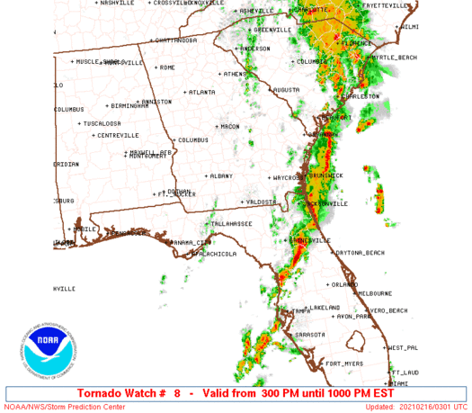
Tornado Watch Number 8
NWS Storm Prediction Center Norman OK
300 PM EST Mon Feb 15 2021
The NWS Storm Prediction Center has issued a
* Tornado Watch for portions of
North Florida
Southern Georgia
Coastal Waters
* Effective this Monday afternoon and evening from 300 PM until
1000 PM EST.
* Primary threats include...
A few tornadoes and a couple intense tornadoes possible
Scattered damaging winds likely with isolated significant gusts
to 75 mph possible
Isolated large hail events to 1.5 inches in diameter possible
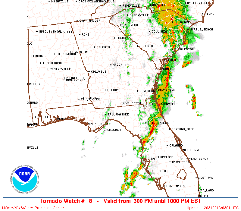
SUMMARY...Multiple rounds of severe thunderstorms are possible. One
regime should emanate northeast across north Florida with a primary
risk for a couple tornadoes and locally damaging winds. The second
regime should spread east-northeast from southeast Alabama and the
Florida Panhandle with a few tornadoes and damaging winds as the
primary hazards.
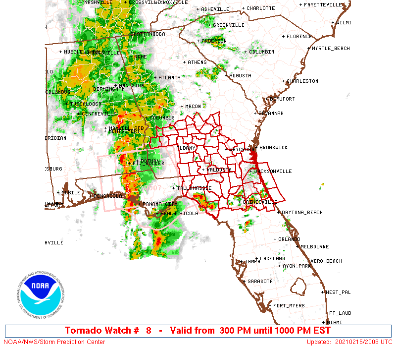
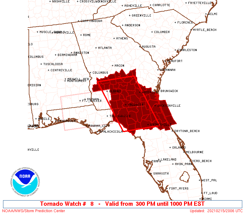
The tornado watch area is approximately along and 60 statute miles
east and west of a line from 50 miles northeast of Albany GA to 25
miles west southwest of Gainesville FL. For a complete depiction of
the watch see the associated watch outline update (WOUS64 KWNS
WOU8).
PRECAUTIONARY/PREPAREDNESS ACTIONS...
REMEMBER...A Tornado Watch means conditions are favorable for
tornadoes and severe thunderstorms in and close to the watch
area. Persons in these areas should be on the lookout for
threatening weather conditions and listen for later statements
and possible warnings.
&&
OTHER WATCH INFORMATION...CONTINUE...WW 7...
AVIATION...Tornadoes and a few severe thunderstorms with hail
surface and aloft to 1.5 inches. Extreme turbulence and surface wind
gusts to 65 knots. A few cumulonimbi with maximum tops to 500. Mean
storm motion vector 22040.
...Grams
 Note:
The Aviation Watch (SAW) product is an approximation to the watch area.
The actual watch is depicted by the shaded areas.
Note:
The Aviation Watch (SAW) product is an approximation to the watch area.
The actual watch is depicted by the shaded areas.
   SAW8
   WW 8 TORNADO FL GA CW 152000Z - 160300Z
   AXIS..60 STATUTE MILES EAST AND WEST OF LINE..
   50NE ABY/ALBANY GA/ - 25WSW GNV/GAINESVILLE FL/
   ..AVIATION COORDS.. 50NM E/W /39S MCN - 21E CTY/
   HAIL SURFACE AND ALOFT..1.5 INCHES. WIND GUSTS..65 KNOTS.
   MAX TOPS TO 500. MEAN STORM MOTION VECTOR 22040.

   LAT...LON 32048257 29548166 29548365 32048462

   THIS IS AN APPROXIMATION TO THE WATCH AREA.  FOR A
   COMPLETE DEPICTION OF THE WATCH SEE WOUS64 KWNS
   FOR WOU8.
Watch 8 Status Report Messages:
STATUS REPORT #8 ON WW 8

VALID 160240Z - 160300Z

SEVERE WEATHER THREAT CONTINUES RIGHT OF A LINE FROM 10 SSW GNV
TO 30 SSW JAX.

REMAINING VALID PORTION OF WW 8 WILL BE ALLOWED TO EXPIRE AT
16/03Z.
..KERR..02/16/21

ATTN...WFO...JAX...TAE...FFC...

&&

STATUS REPORT FOR WT 8

SEVERE WEATHER THREAT CONTINUES FOR THE FOLLOWING AREAS

FLC001-035-107-109-160300-

FL
.    FLORIDA COUNTIES INCLUDED ARE

ALACHUA 	     FLAGLER		 PUTNAM
ST. JOHNS
$$


AMZ452-454-160300-

CW

.    ADJACENT COASTAL WATERS INCLUDED ARE

COASTAL WATERS FROM FERNANDINA BEACH TO ST. AUGUSTINE FL OUT 20
NM

COASTAL WATERS FROM ST. AUGUSTINE TO FLAGLER BEACH FL OUT 20 NM

$$
THE WATCH STATUS MESSAGE IS FOR GUIDANCE PURPOSES ONLY.  PLEASE
REFER TO WATCH COUNTY NOTIFICATION STATEMENTS FOR OFFICIAL
INFORMATION ON COUNTIES...INDEPENDENT CITIES AND MARINE ZONES
CLEARED FROM SEVERE THUNDERSTORM AND TORNADO WATCHES.
$$

STATUS REPORT #7 ON WW 8

VALID 160130Z - 160240Z

SEVERE WEATHER THREAT CONTINUES RIGHT OF A LINE FROM 25 WSW GNV
TO 25 WNW JAX.

..KERR..02/16/21

ATTN...WFO...JAX...TAE...FFC...

&&

STATUS REPORT FOR WT 8

SEVERE WEATHER THREAT CONTINUES FOR THE FOLLOWING AREAS

FLC001-007-019-031-035-041-089-107-109-125-160240-

FL
.    FLORIDA COUNTIES INCLUDED ARE

ALACHUA 	     BRADFORD		 CLAY
DUVAL		     FLAGLER		 GILCHRIST
NASSAU		     PUTNAM		 ST. JOHNS
UNION
$$


GAC025-039-160240-

GA
.    GEORGIA COUNTIES INCLUDED ARE

BRANTLEY	     CAMDEN
$$


AMZ452-454-160240-

CW

.    ADJACENT COASTAL WATERS INCLUDED ARE

COASTAL WATERS FROM FERNANDINA BEACH TO ST. AUGUSTINE FL OUT 20
NM

COASTAL WATERS FROM ST. AUGUSTINE TO FLAGLER BEACH FL OUT 20 NM

$$
THE WATCH STATUS MESSAGE IS FOR GUIDANCE PURPOSES ONLY.  PLEASE
REFER TO WATCH COUNTY NOTIFICATION STATEMENTS FOR OFFICIAL
INFORMATION ON COUNTIES...INDEPENDENT CITIES AND MARINE ZONES
CLEARED FROM SEVERE THUNDERSTORM AND TORNADO WATCHES.
$$

STATUS REPORT #6 ON WW 8

VALID 160105Z - 160240Z

SEVERE WEATHER THREAT CONTINUES RIGHT OF A LINE FROM 10 SE CTY TO
40 S AYS TO 10 NNE AYS.

..KERR..02/16/21

ATTN...WFO...JAX...TAE...FFC...

&&

STATUS REPORT FOR WT 8

SEVERE WEATHER THREAT CONTINUES FOR THE FOLLOWING AREAS

FLC001-003-007-019-023-031-035-041-089-107-109-125-160240-

FL
.    FLORIDA COUNTIES INCLUDED ARE

ALACHUA 	     BAKER		 BRADFORD
CLAY		     COLUMBIA		 DUVAL
FLAGLER 	     GILCHRIST		 NASSAU
PUTNAM		     ST. JOHNS		 UNION
$$


GAC025-039-049-229-160240-

GA
.    GEORGIA COUNTIES INCLUDED ARE

BRANTLEY	     CAMDEN		 CHARLTON
PIERCE
$$


AMZ452-454-160240-

CW

.    ADJACENT COASTAL WATERS INCLUDED ARE

COASTAL WATERS FROM FERNANDINA BEACH TO ST. AUGUSTINE FL OUT 20
NM

COASTAL WATERS FROM ST. AUGUSTINE TO FLAGLER BEACH FL OUT 20 NM

$$
THE WATCH STATUS MESSAGE IS FOR GUIDANCE PURPOSES ONLY.  PLEASE
REFER TO WATCH COUNTY NOTIFICATION STATEMENTS FOR OFFICIAL
INFORMATION ON COUNTIES...INDEPENDENT CITIES AND MARINE ZONES
CLEARED FROM SEVERE THUNDERSTORM AND TORNADO WATCHES.
$$

STATUS REPORT #5 ON WW 8

VALID 160100Z - 160240Z

SEVERE WEATHER THREAT CONTINUES RIGHT OF A LINE FROM 10 SE CTY TO
40 S AYS TO 10 NNE AYS.

..KERR..02/16/21

ATTN...WFO...JAX...TAE...FFC...

&&

STATUS REPORT FOR WT 8

SEVERE WEATHER THREAT CONTINUES FOR THE FOLLOWING AREAS

FLC001-003-007-019-023-031-035-041-089-107-109-125-160240-

FL
.    FLORIDA COUNTIES INCLUDED ARE

ALACHUA 	     BAKER		 BRADFORD
CLAY		     COLUMBIA		 DUVAL
FLAGLER 	     GILCHRIST		 NASSAU
PUTNAM		     ST. JOHNS		 UNION
$$


GAC025-039-049-229-160240-

GA
.    GEORGIA COUNTIES INCLUDED ARE

BRANTLEY	     CAMDEN		 CHARLTON
PIERCE
$$


AMZ452-454-160240-

CW

.    ADJACENT COASTAL WATERS INCLUDED ARE

COASTAL WATERS FROM FERNANDINA BEACH TO ST. AUGUSTINE FL OUT 20
NM

COASTAL WATERS FROM ST. AUGUSTINE TO FLAGLER BEACH FL OUT 20 NM

$$
THE WATCH STATUS MESSAGE IS FOR GUIDANCE PURPOSES ONLY.  PLEASE
REFER TO WATCH COUNTY NOTIFICATION STATEMENTS FOR OFFICIAL
INFORMATION ON COUNTIES...INDEPENDENT CITIES AND MARINE ZONES
CLEARED FROM SEVERE THUNDERSTORM AND TORNADO WATCHES.
$$

STATUS REPORT #4 ON WW 8

VALID 152340Z - 160040Z

SEVERE WEATHER THREAT CONTINUES RIGHT OF A LINE FROM 35 W CTY TO
35 SSW VLD TO 15 ESE MGR TO 25 NNE MGR TO 55 SSE MCN TO 45 W VDI.

..LYONS..02/15/21

ATTN...WFO...JAX...TAE...FFC...

&&

STATUS REPORT FOR WT 8

SEVERE WEATHER THREAT CONTINUES FOR THE FOLLOWING AREAS

FLC001-003-007-019-023-029-031-035-041-047-067-089-107-109-121-
125-160040-

FL
.    FLORIDA COUNTIES INCLUDED ARE

ALACHUA 	     BAKER		 BRADFORD
CLAY		     COLUMBIA		 DIXIE
DUVAL		     FLAGLER		 GILCHRIST
HAMILTON	     LAFAYETTE		 NASSAU
PUTNAM		     ST. JOHNS		 SUWANNEE
UNION
$$


GAC003-005-017-019-025-039-049-065-069-091-101-155-161-173-185-
209-229-271-277-299-309-160040-

GA
.    GEORGIA COUNTIES INCLUDED ARE

ATKINSON	     BACON		 BEN HILL
BERRIEN 	     BRANTLEY		 CAMDEN
CHARLTON	     CLINCH		 COFFEE
DODGE		     ECHOLS		 IRWIN
JEFF DAVIS	     LANIER		 LOWNDES
MONTGOMERY	     PIERCE		 TELFAIR
TIFT		     WARE		 WHEELER
$$


AMZ452-454-160040-

CW

.    ADJACENT COASTAL WATERS INCLUDED ARE

COASTAL WATERS FROM FERNANDINA BEACH TO ST. AUGUSTINE FL OUT 20
NM

COASTAL WATERS FROM ST. AUGUSTINE TO FLAGLER BEACH FL OUT 20 NM

$$
THE WATCH STATUS MESSAGE IS FOR GUIDANCE PURPOSES ONLY.  PLEASE
REFER TO WATCH COUNTY NOTIFICATION STATEMENTS FOR OFFICIAL
INFORMATION ON COUNTIES...INDEPENDENT CITIES AND MARINE ZONES
CLEARED FROM SEVERE THUNDERSTORM AND TORNADO WATCHES.
$$

STATUS REPORT #3 ON WW 8

VALID 152230Z - 152340Z

SEVERE WEATHER THREAT CONTINUES RIGHT OF A LINE FROM 25 NW ABY TO
35 NNE ABY TO 35 S MCN TO 25 SSE MCN TO 20 E MCN.

..LYONS..02/15/21

ATTN...WFO...JAX...TAE...FFC...

&&

STATUS REPORT FOR WT 8

SEVERE WEATHER THREAT CONTINUES FOR THE FOLLOWING AREAS

FLC001-003-007-019-023-029-031-035-041-047-065-067-079-089-107-
109-121-123-125-152340-

FL
.    FLORIDA COUNTIES INCLUDED ARE

ALACHUA 	     BAKER		 BRADFORD
CLAY		     COLUMBIA		 DIXIE
DUVAL		     FLAGLER		 GILCHRIST
HAMILTON	     JEFFERSON		 LAFAYETTE
MADISON 	     NASSAU		 PUTNAM
ST. JOHNS	     SUWANNEE		 TAYLOR
UNION
$$


GAC003-005-017-019-025-027-039-049-065-069-071-075-081-091-093-
101-155-161-173-177-185-209-229-235-271-275-277-287-299-309-315-
321-152340-

GA
.    GEORGIA COUNTIES INCLUDED ARE

ATKINSON	     BACON		 BEN HILL
BERRIEN 	     BRANTLEY		 BROOKS
CAMDEN		     CHARLTON		 CLINCH
COFFEE		     COLQUITT		 COOK
CRISP		     DODGE		 DOOLY
ECHOLS		     IRWIN		 JEFF DAVIS
LANIER		     LEE		 LOWNDES
MONTGOMERY	     PIERCE		 PULASKI
TELFAIR 	     THOMAS		 TIFT
TURNER		     WARE		 WHEELER
WILCOX		     WORTH
$$


AMZ452-454-152340-

CW

.    ADJACENT COASTAL WATERS INCLUDED ARE

COASTAL WATERS FROM FERNANDINA BEACH TO ST. AUGUSTINE FL OUT 20
NM

COASTAL WATERS FROM ST. AUGUSTINE TO FLAGLER BEACH FL OUT 20 NM

$$
THE WATCH STATUS MESSAGE IS FOR GUIDANCE PURPOSES ONLY.  PLEASE
REFER TO WATCH COUNTY NOTIFICATION STATEMENTS FOR OFFICIAL
INFORMATION ON COUNTIES...INDEPENDENT CITIES AND MARINE ZONES
CLEARED FROM SEVERE THUNDERSTORM AND TORNADO WATCHES.
$$

STATUS REPORT #2 ON WW 8

VALID 152115Z - 152240Z

THE SEVERE WEATHER THREAT CONTINUES ACROSS THE ENTIRE WATCH AREA.

FOR ADDITIONAL INFORMATION SEE MESOSCALE DISCUSSION 94

..LYONS..02/15/21

ATTN...WFO...JAX...TAE...FFC...

&&

STATUS REPORT FOR WT 8

SEVERE WEATHER THREAT CONTINUES FOR THE FOLLOWING AREAS

FLC001-003-007-019-023-029-031-035-041-047-065-067-079-089-107-
109-121-123-125-152240-

FL
.    FLORIDA COUNTIES INCLUDED ARE

ALACHUA 	     BAKER		 BRADFORD
CLAY		     COLUMBIA		 DIXIE
DUVAL		     FLAGLER		 GILCHRIST
HAMILTON	     JEFFERSON		 LAFAYETTE
MADISON 	     NASSAU		 PUTNAM
ST. JOHNS	     SUWANNEE		 TAYLOR
UNION
$$


GAC003-005-017-019-025-027-039-049-065-069-071-075-081-091-093-
101-155-161-173-177-185-209-229-235-243-261-271-273-275-277-287-
299-307-309-315-321-152240-

GA
.    GEORGIA COUNTIES INCLUDED ARE

ATKINSON	     BACON		 BEN HILL
BERRIEN 	     BRANTLEY		 BROOKS
CAMDEN		     CHARLTON		 CLINCH
COFFEE		     COLQUITT		 COOK
CRISP		     DODGE		 DOOLY
ECHOLS		     IRWIN		 JEFF DAVIS
LANIER		     LEE		 LOWNDES
MONTGOMERY	     PIERCE		 PULASKI
RANDOLPH	     SUMTER		 TELFAIR
TERRELL 	     THOMAS		 TIFT
TURNER		     WARE		 WEBSTER
WHEELER 	     WILCOX		 WORTH
$$


AMZ452-454-152240-

CW

.    ADJACENT COASTAL WATERS INCLUDED ARE

COASTAL WATERS FROM FERNANDINA BEACH TO ST. AUGUSTINE FL OUT 20
NM

COASTAL WATERS FROM ST. AUGUSTINE TO FLAGLER BEACH FL OUT 20 NM

$$
THE WATCH STATUS MESSAGE IS FOR GUIDANCE PURPOSES ONLY.  PLEASE
REFER TO WATCH COUNTY NOTIFICATION STATEMENTS FOR OFFICIAL
INFORMATION ON COUNTIES...INDEPENDENT CITIES AND MARINE ZONES
CLEARED FROM SEVERE THUNDERSTORM AND TORNADO WATCHES.
$$

STATUS REPORT #1 ON WW 8

VALID 152030Z - 152140Z

THE SEVERE WEATHER THREAT CONTINUES ACROSS THE ENTIRE WATCH AREA.

FOR ADDITIONAL INFORMATION SEE MESOSCALE DISCUSSION 92

..LYONS..02/15/21

ATTN...WFO...JAX...TAE...FFC...

&&

STATUS REPORT FOR WT 8

SEVERE WEATHER THREAT CONTINUES FOR THE FOLLOWING AREAS

FLC001-003-007-019-023-029-031-035-041-047-065-067-079-089-107-
109-121-123-125-152140-

FL
.    FLORIDA COUNTIES INCLUDED ARE

ALACHUA 	     BAKER		 BRADFORD
CLAY		     COLUMBIA		 DIXIE
DUVAL		     FLAGLER		 GILCHRIST
HAMILTON	     JEFFERSON		 LAFAYETTE
MADISON 	     NASSAU		 PUTNAM
ST. JOHNS	     SUWANNEE		 TAYLOR
UNION
$$


GAC003-005-017-019-025-027-039-049-065-069-071-075-081-091-093-
101-155-161-173-177-185-209-229-235-243-261-271-273-275-277-287-
299-307-309-315-321-152140-

GA
.    GEORGIA COUNTIES INCLUDED ARE

ATKINSON	     BACON		 BEN HILL
BERRIEN 	     BRANTLEY		 BROOKS
CAMDEN		     CHARLTON		 CLINCH
COFFEE		     COLQUITT		 COOK
CRISP		     DODGE		 DOOLY
ECHOLS		     IRWIN		 JEFF DAVIS
LANIER		     LEE		 LOWNDES
MONTGOMERY	     PIERCE		 PULASKI
RANDOLPH	     SUMTER		 TELFAIR
TERRELL 	     THOMAS		 TIFT
TURNER		     WARE		 WEBSTER
WHEELER 	     WILCOX		 WORTH
$$


AMZ452-454-152140-

CW

.    ADJACENT COASTAL WATERS INCLUDED ARE

COASTAL WATERS FROM FERNANDINA BEACH TO ST. AUGUSTINE FL OUT 20
NM

COASTAL WATERS FROM ST. AUGUSTINE TO FLAGLER BEACH FL OUT 20 NM

$$
THE WATCH STATUS MESSAGE IS FOR GUIDANCE PURPOSES ONLY.  PLEASE
REFER TO WATCH COUNTY NOTIFICATION STATEMENTS FOR OFFICIAL
INFORMATION ON COUNTIES...INDEPENDENT CITIES AND MARINE ZONES
CLEARED FROM SEVERE THUNDERSTORM AND TORNADO WATCHES.
$$
Note:
Click for Complete Product Text.
Tornadoes
Probability of 2 or more tornadoes
|
Mod (50%)
|
Probability of 1 or more strong (EF2-EF5) tornadoes
|
Mod (30%)
|
Wind
Probability of 10 or more severe wind events
|
Mod (60%)
|
Probability of 1 or more wind events > 65 knots
|
Mod (40%)
|
Hail
Probability of 10 or more severe hail events
|
Low (20%)
|
Probability of 1 or more hailstones > 2 inches
|
Low (10%)
|
Combined Severe Hail/Wind
Probability of 6 or more combined severe hail/wind events
|
High (80%)
|
For each watch, probabilities for particular events inside the watch
(listed above in each table) are determined by the issuing forecaster.
The "Low" category contains probability values ranging from less than 2%
to 20% (EF2-EF5 tornadoes), less than 5% to 20% (all other probabilities),
"Moderate" from 30% to 60%, and "High" from 70% to greater than 95%.
High values are bolded and lighter in color to provide awareness of
an increased threat for a particular event.


 @NWSSPC