 Note:
The expiration time in the watch graphic is amended if the watch is
replaced, cancelled or extended.
Note:
Note:
The expiration time in the watch graphic is amended if the watch is
replaced, cancelled or extended.
Note: Click for
Watch Status Reports.
SEL6
URGENT - IMMEDIATE BROADCAST REQUESTED
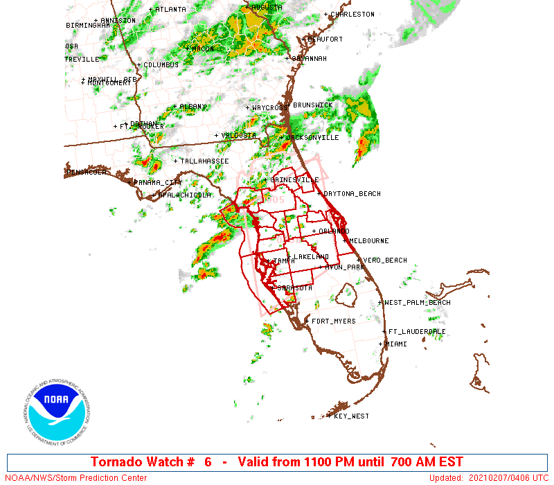
Tornado Watch Number 6
NWS Storm Prediction Center Norman OK
1100 PM EST Sat Feb 6 2021
The NWS Storm Prediction Center has issued a
* Tornado Watch for portions of
North and central Florida
Coastal Waters
* Effective this Saturday night and Sunday morning from 1100 PM
until 700 AM EST.
* Primary threats include...
A couple intense tornadoes possible
Isolated damaging wind gusts to 70 mph possible
Isolated large hail events to 1.5 inches in diameter possible
SUMMARY...Multiple supercells are expected to spread inland from the
northeast Gulf across portions of north and central Florida
overnight. The environment will support a risk of a couple tornadoes
along with isolated damaging winds and marginally severe hail.
The tornado watch area is approximately along and 80 statute miles
north and south of a line from 15 miles west northwest of Saint
Petersburg FL to 25 miles south southeast of Daytona Beach FL. For a
complete depiction of the watch see the associated watch outline
update (WOUS64 KWNS WOU6).
PRECAUTIONARY/PREPAREDNESS ACTIONS...
REMEMBER...A Tornado Watch means conditions are favorable for
tornadoes and severe thunderstorms in and close to the watch
area. Persons in these areas should be on the lookout for
threatening weather conditions and listen for later statements
and possible warnings.
&&
AVIATION...Tornadoes and a few severe thunderstorms with hail
surface and aloft to 1.5 inches. Extreme turbulence and surface wind
gusts to 60 knots. A few cumulonimbi with maximum tops to 500. Mean
storm motion vector 24040.
...Grams
 Note:
The Aviation Watch (SAW) product is an approximation to the watch area.
The actual watch is depicted by the shaded areas.
Note:
The Aviation Watch (SAW) product is an approximation to the watch area.
The actual watch is depicted by the shaded areas.
   SAW6
   WW 6 TORNADO FL CW 070400Z - 071200Z
   AXIS..80 STATUTE MILES NORTH AND SOUTH OF LINE..
   15WNW PIE/SAINT PETERSBURG FL/ - 25SSE DAB/DAYTONA BEACH FL/
   ..AVIATION COORDS.. 70NM N/S /13WNW PIE - 30SSE OMN/
   HAIL SURFACE AND ALOFT..1.5 INCHES. WIND GUSTS..60 KNOTS.
   MAX TOPS TO 500. MEAN STORM MOTION VECTOR 24040.

   LAT...LON 29168291 30008089 27698089 26858291

   THIS IS AN APPROXIMATION TO THE WATCH AREA.  FOR A
   COMPLETE DEPICTION OF THE WATCH SEE WOUS64 KWNS
   FOR WOU6.
Watch 6 Status Report Messages:
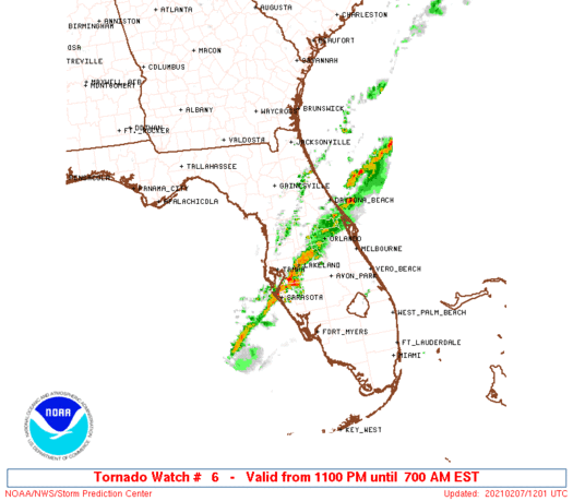
STATUS REPORT #2 ON WW 6
VALID 071040Z - 071140Z
SEVERE WEATHER THREAT CONTINUES RIGHT OF A LINE FROM 25 W PIE TO
35 SSE OCF TO 35 NNE DAB.
..BROYLES..02/07/21
ATTN...WFO...MLB...TBW...JAX...
&&
STATUS REPORT FOR WT 6
SEVERE WEATHER THREAT CONTINUES FOR THE FOLLOWING AREAS
FLC009-049-057-069-081-095-097-101-103-105-115-117-127-071140-
FL
. FLORIDA COUNTIES INCLUDED ARE
BREVARD HARDEE HILLSBOROUGH
LAKE MANATEE ORANGE
OSCEOLA PASCO PINELLAS
POLK SARASOTA SEMINOLE
VOLUSIA
$$
AMZ550-552-GMZ830-853-071140-
CW
. ADJACENT COASTAL WATERS INCLUDED ARE
FLAGLER BEACH TO VOLUSIA-BREVARD COUNTY LINE 0-20 NM
VOLUSIA-BREVARD COUNTY LINE TO SEBASTIAN INLET 0-20 NM
TAMPA BAY WATERS
COASTAL WATERS FROM ENGLEWOOD TO TARPON SPRINGS FL OUT 20 NM
$$
THE WATCH STATUS MESSAGE IS FOR GUIDANCE PURPOSES ONLY. PLEASE
REFER TO WATCH COUNTY NOTIFICATION STATEMENTS FOR OFFICIAL
INFORMATION ON COUNTIES...INDEPENDENT CITIES AND MARINE ZONES
CLEARED FROM SEVERE THUNDERSTORM AND TORNADO WATCHES.
$$
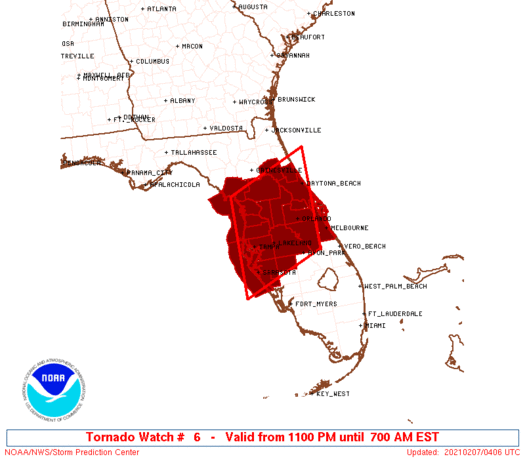
STATUS REPORT #1 ON WW 6
VALID 070830Z - 070940Z
THE SEVERE WEATHER THREAT CONTINUES ACROSS THE ENTIRE WATCH AREA.
..BROYLES..02/07/21
ATTN...WFO...MLB...TBW...JAX...
&&
STATUS REPORT FOR WT 6
SEVERE WEATHER THREAT CONTINUES FOR THE FOLLOWING AREAS
FLC009-017-035-049-053-057-069-075-081-083-095-097-101-103-105-
107-115-117-119-127-070940-
FL
. FLORIDA COUNTIES INCLUDED ARE
BREVARD CITRUS FLAGLER
HARDEE HERNANDO HILLSBOROUGH
LAKE LEVY MANATEE
MARION ORANGE OSCEOLA
PASCO PINELLAS POLK
PUTNAM SARASOTA SEMINOLE
SUMTER VOLUSIA
$$
AMZ550-552-GMZ830-850-853-070940-
CW
. ADJACENT COASTAL WATERS INCLUDED ARE
FLAGLER BEACH TO VOLUSIA-BREVARD COUNTY LINE 0-20 NM
VOLUSIA-BREVARD COUNTY LINE TO SEBASTIAN INLET 0-20 NM
TAMPA BAY WATERS
COASTAL WATERS FROM TARPON SPRINGS TO SUWANNEE RIVER FL OUT 20 NM
COASTAL WATERS FROM ENGLEWOOD TO TARPON SPRINGS FL OUT 20 NM
$$
THE WATCH STATUS MESSAGE IS FOR GUIDANCE PURPOSES ONLY. PLEASE
REFER TO WATCH COUNTY NOTIFICATION STATEMENTS FOR OFFICIAL
INFORMATION ON COUNTIES...INDEPENDENT CITIES AND MARINE ZONES
CLEARED FROM SEVERE THUNDERSTORM AND TORNADO WATCHES.
$$
Note:
Click for Complete Product Text.
Tornadoes
Probability of 2 or more tornadoes
|
Mod (40%)
|
Probability of 1 or more strong (EF2-EF5) tornadoes
|
Mod (30%)
|
Wind
Probability of 10 or more severe wind events
|
Mod (30%)
|
Probability of 1 or more wind events > 65 knots
|
Low (20%)
|
Hail
Probability of 10 or more severe hail events
|
Low (20%)
|
Probability of 1 or more hailstones > 2 inches
|
Low (10%)
|
Combined Severe Hail/Wind
Probability of 6 or more combined severe hail/wind events
|
Mod (50%)
|
For each watch, probabilities for particular events inside the watch
(listed above in each table) are determined by the issuing forecaster.
The "Low" category contains probability values ranging from less than 2%
to 20% (EF2-EF5 tornadoes), less than 5% to 20% (all other probabilities),
"Moderate" from 30% to 60%, and "High" from 70% to greater than 95%.
High values are bolded and lighter in color to provide awareness of
an increased threat for a particular event.


 @NWSSPC