 Note:
The expiration time in the watch graphic is amended if the watch is
replaced, cancelled or extended.
Note:
Note:
The expiration time in the watch graphic is amended if the watch is
replaced, cancelled or extended.
Note: Click for
Watch Status Reports.
SEL5
URGENT - IMMEDIATE BROADCAST REQUESTED
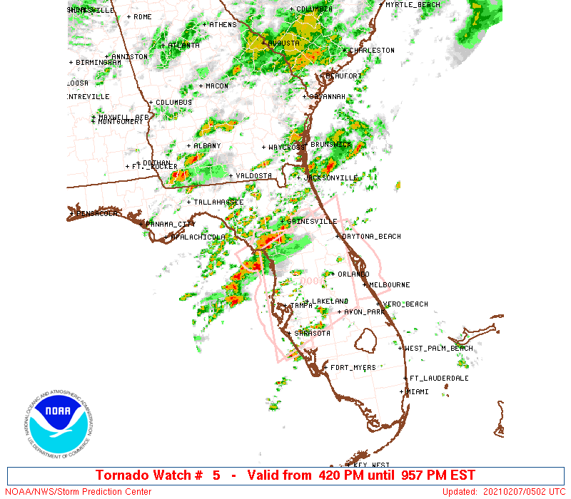
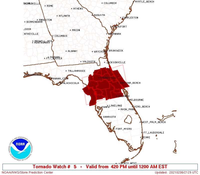
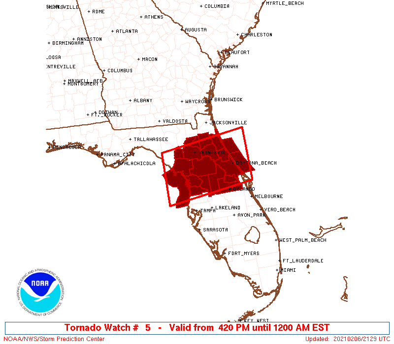
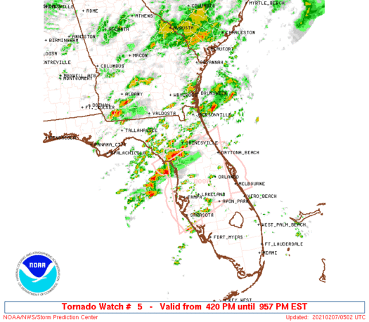
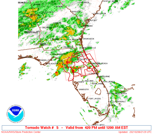
Tornado Watch Number 5
NWS Storm Prediction Center Norman OK
420 PM EST Sat Feb 6 2021
The NWS Storm Prediction Center has issued a
* Tornado Watch for portions of
North Central Florida
Coastal Waters
* Effective this Saturday afternoon from 420 PM until Midnight
EST.
* Primary threats include...
A couple tornadoes possible
Scattered damaging wind gusts to 70 mph possible
Scattered large hail events to 1.5 inches in diameter possible
SUMMARY...Thunderstorms are increasing off the west coast of
Florida, as well as isolated storms forming over the central
peninsula. All of these storms pose a risk of intensifying to
severe levels, capable of damaging winds, hail, and a few tornadoes.
The tornado watch area is approximately along and 55 statute miles
north and south of a line from 45 miles south southwest of Cross
City FL to 35 miles east northeast of Daytona Beach FL. For a
complete depiction of the watch see the associated watch outline
update (WOUS64 KWNS WOU5).
PRECAUTIONARY/PREPAREDNESS ACTIONS...
REMEMBER...A Tornado Watch means conditions are favorable for
tornadoes and severe thunderstorms in and close to the watch
area. Persons in these areas should be on the lookout for
threatening weather conditions and listen for later statements
and possible warnings.
&&
AVIATION...Tornadoes and a few severe thunderstorms with hail
surface and aloft to 1.5 inches. Extreme turbulence and surface wind
gusts to 60 knots. A few cumulonimbi with maximum tops to 450. Mean
storm motion vector 24030.
...Hart
   SEL5

   URGENT - IMMEDIATE BROADCAST REQUESTED
   Tornado Watch Number 5
   NWS Storm Prediction Center Norman OK
   420 PM EST Sat Feb 6 2021

   The NWS Storm Prediction Center has issued a

   * Tornado Watch for portions of
     North Central Florida
     Coastal Waters

   * Effective this Saturday afternoon from 420 PM until Midnight
     EST.

   * Primary threats include...
     A couple tornadoes possible
     Scattered damaging wind gusts to 70 mph possible
     Scattered large hail events to 1.5 inches in diameter possible

   SUMMARY...Thunderstorms are increasing off the west coast of
   Florida, as well as isolated storms forming over the central
   peninsula.  All of these storms pose a risk of intensifying to
   severe levels, capable of damaging winds, hail, and a few tornadoes.

   The tornado watch area is approximately along and 55 statute miles
   north and south of a line from 45 miles south southwest of Cross
   City FL to 35 miles east northeast of Daytona Beach FL. For a
   complete depiction of the watch see the associated watch outline
   update (WOUS64 KWNS WOU5).

   PRECAUTIONARY/PREPAREDNESS ACTIONS...

   REMEMBER...A Tornado Watch means conditions are favorable for
   tornadoes and severe thunderstorms in and close to the watch
   area. Persons in these areas should be on the lookout for
   threatening weather conditions and listen for later statements
   and possible warnings.

   &&

   AVIATION...Tornadoes and a few severe thunderstorms with hail
   surface and aloft to 1.5 inches. Extreme turbulence and surface wind
   gusts to 60 knots. A few cumulonimbi with maximum tops to 450. Mean
   storm motion vector 24030.

   ...Hart
 Note:
The Aviation Watch (SAW) product is an approximation to the watch area.
The actual watch is depicted by the shaded areas.
Note:
The Aviation Watch (SAW) product is an approximation to the watch area.
The actual watch is depicted by the shaded areas.
   SAW5
   WW 5 TORNADO FL CW 062120Z - 070500Z
   AXIS..55 STATUTE MILES NORTH AND SOUTH OF LINE..
   45SSW CTY/CROSS CITY FL/ - 35ENE DAB/DAYTONA BEACH FL/
   ..AVIATION COORDS.. 50NM N/S /39SSW CTY - 32E OMN/
   HAIL SURFACE AND ALOFT..1.5 INCHES. WIND GUSTS..60 KNOTS.
   MAX TOPS TO 450. MEAN STORM MOTION VECTOR 24030.

   LAT...LON 29828339 30178051 28588051 28238339

   THIS IS AN APPROXIMATION TO THE WATCH AREA.  FOR A
   COMPLETE DEPICTION OF THE WATCH SEE WOUS64 KWNS
   FOR WOU5.
Watch 5 Status Report Messages:
STATUS REPORT #4 ON WW 5

VALID 070135Z - 070240Z

THE SEVERE WEATHER THREAT CONTINUES ACROSS THE ENTIRE WATCH AREA.

FOR ADDITIONAL INFORMATION SEE MESOSCALE DISCUSSION 59

..KARSTENS..02/07/21

ATTN...WFO...JAX...TBW...MLB...

&&

STATUS REPORT FOR WT 5

SEVERE WEATHER THREAT CONTINUES FOR THE FOLLOWING AREAS

FLC001-007-017-019-035-041-053-069-075-083-095-107-109-117-119-
125-127-070240-

FL
.    FLORIDA COUNTIES INCLUDED ARE

ALACHUA 	     BRADFORD		 CITRUS
CLAY		     FLAGLER		 GILCHRIST
HERNANDO	     LAKE		 LEVY
MARION		     ORANGE		 PUTNAM
ST. JOHNS	     SEMINOLE		 SUMTER
UNION		     VOLUSIA
$$


AMZ454-550-GMZ850-070240-

CW

.    ADJACENT COASTAL WATERS INCLUDED ARE

COASTAL WATERS FROM ST. AUGUSTINE TO FLAGLER BEACH FL OUT 20 NM

FLAGLER BEACH TO VOLUSIA-BREVARD COUNTY LINE 0-20 NM

COASTAL WATERS FROM TARPON SPRINGS TO SUWANNEE RIVER FL OUT 20 NM

$$
THE WATCH STATUS MESSAGE IS FOR GUIDANCE PURPOSES ONLY.  PLEASE
REFER TO WATCH COUNTY NOTIFICATION STATEMENTS FOR OFFICIAL
INFORMATION ON COUNTIES...INDEPENDENT CITIES AND MARINE ZONES
CLEARED FROM SEVERE THUNDERSTORM AND TORNADO WATCHES.
$$

STATUS REPORT #3 ON WW 5

VALID 070035Z - 070140Z

THE SEVERE WEATHER THREAT CONTINUES ACROSS THE ENTIRE WATCH AREA.

..KARSTENS..02/07/21

ATTN...WFO...JAX...TBW...MLB...

&&

STATUS REPORT FOR WT 5

SEVERE WEATHER THREAT CONTINUES FOR THE FOLLOWING AREAS

FLC001-007-017-019-035-041-053-069-075-083-095-107-109-117-119-
125-127-070140-

FL
.    FLORIDA COUNTIES INCLUDED ARE

ALACHUA 	     BRADFORD		 CITRUS
CLAY		     FLAGLER		 GILCHRIST
HERNANDO	     LAKE		 LEVY
MARION		     ORANGE		 PUTNAM
ST. JOHNS	     SEMINOLE		 SUMTER
UNION		     VOLUSIA
$$


AMZ454-550-GMZ850-070140-

CW

.    ADJACENT COASTAL WATERS INCLUDED ARE

COASTAL WATERS FROM ST. AUGUSTINE TO FLAGLER BEACH FL OUT 20 NM

FLAGLER BEACH TO VOLUSIA-BREVARD COUNTY LINE 0-20 NM

COASTAL WATERS FROM TARPON SPRINGS TO SUWANNEE RIVER FL OUT 20 NM

$$
THE WATCH STATUS MESSAGE IS FOR GUIDANCE PURPOSES ONLY.  PLEASE
REFER TO WATCH COUNTY NOTIFICATION STATEMENTS FOR OFFICIAL
INFORMATION ON COUNTIES...INDEPENDENT CITIES AND MARINE ZONES
CLEARED FROM SEVERE THUNDERSTORM AND TORNADO WATCHES.
$$

STATUS REPORT #2 ON WW 5

VALID 062335Z - 070040Z

THE SEVERE WEATHER THREAT CONTINUES ACROSS THE ENTIRE WATCH AREA.

..KARSTENS..02/06/21

ATTN...WFO...JAX...TBW...MLB...

&&

STATUS REPORT FOR WT 5

SEVERE WEATHER THREAT CONTINUES FOR THE FOLLOWING AREAS

FLC001-007-017-019-035-041-053-069-075-083-095-107-109-117-119-
125-127-070040-

FL
.    FLORIDA COUNTIES INCLUDED ARE

ALACHUA 	     BRADFORD		 CITRUS
CLAY		     FLAGLER		 GILCHRIST
HERNANDO	     LAKE		 LEVY
MARION		     ORANGE		 PUTNAM
ST. JOHNS	     SEMINOLE		 SUMTER
UNION		     VOLUSIA
$$


AMZ454-550-GMZ850-070040-

CW

.    ADJACENT COASTAL WATERS INCLUDED ARE

COASTAL WATERS FROM ST. AUGUSTINE TO FLAGLER BEACH FL OUT 20 NM

FLAGLER BEACH TO VOLUSIA-BREVARD COUNTY LINE 0-20 NM

COASTAL WATERS FROM TARPON SPRINGS TO SUWANNEE RIVER FL OUT 20 NM

$$
THE WATCH STATUS MESSAGE IS FOR GUIDANCE PURPOSES ONLY.  PLEASE
REFER TO WATCH COUNTY NOTIFICATION STATEMENTS FOR OFFICIAL
INFORMATION ON COUNTIES...INDEPENDENT CITIES AND MARINE ZONES
CLEARED FROM SEVERE THUNDERSTORM AND TORNADO WATCHES.
$$

STATUS REPORT #1 ON WW 5

VALID 062230Z - 062340Z

THE SEVERE WEATHER THREAT CONTINUES ACROSS THE ENTIRE WATCH AREA.

FOR ADDITIONAL INFORMATION SEE MESOSCALE DISCUSSION 58

..KARSTENS..02/06/21

ATTN...WFO...JAX...TBW...MLB...

&&

STATUS REPORT FOR WT 5

SEVERE WEATHER THREAT CONTINUES FOR THE FOLLOWING AREAS

FLC001-007-017-019-035-041-053-069-075-083-095-107-109-117-119-
125-127-062340-

FL
.    FLORIDA COUNTIES INCLUDED ARE

ALACHUA 	     BRADFORD		 CITRUS
CLAY		     FLAGLER		 GILCHRIST
HERNANDO	     LAKE		 LEVY
MARION		     ORANGE		 PUTNAM
ST. JOHNS	     SEMINOLE		 SUMTER
UNION		     VOLUSIA
$$


AMZ454-550-GMZ850-062340-

CW

.    ADJACENT COASTAL WATERS INCLUDED ARE

COASTAL WATERS FROM ST. AUGUSTINE TO FLAGLER BEACH FL OUT 20 NM

FLAGLER BEACH TO VOLUSIA-BREVARD COUNTY LINE 0-20 NM

COASTAL WATERS FROM TARPON SPRINGS TO SUWANNEE RIVER FL OUT 20 NM

$$
THE WATCH STATUS MESSAGE IS FOR GUIDANCE PURPOSES ONLY.  PLEASE
REFER TO WATCH COUNTY NOTIFICATION STATEMENTS FOR OFFICIAL
INFORMATION ON COUNTIES...INDEPENDENT CITIES AND MARINE ZONES
CLEARED FROM SEVERE THUNDERSTORM AND TORNADO WATCHES.
$$
Note:
Click for Complete Product Text.
Tornadoes
Probability of 2 or more tornadoes
|
Mod (40%)
|
Probability of 1 or more strong (EF2-EF5) tornadoes
|
Low (10%)
|
Wind
Probability of 10 or more severe wind events
|
Mod (40%)
|
Probability of 1 or more wind events > 65 knots
|
Low (20%)
|
Hail
Probability of 10 or more severe hail events
|
Mod (40%)
|
Probability of 1 or more hailstones > 2 inches
|
Low (10%)
|
Combined Severe Hail/Wind
Probability of 6 or more combined severe hail/wind events
|
High (70%)
|
For each watch, probabilities for particular events inside the watch
(listed above in each table) are determined by the issuing forecaster.
The "Low" category contains probability values ranging from less than 2%
to 20% (EF2-EF5 tornadoes), less than 5% to 20% (all other probabilities),
"Moderate" from 30% to 60%, and "High" from 70% to greater than 95%.
High values are bolded and lighter in color to provide awareness of
an increased threat for a particular event.


 @NWSSPC