Note:
The expiration time in the watch graphic is amended if the watch is
replaced, cancelled or extended.
Note:
Note:
The expiration time in the watch graphic is amended if the watch is
replaced, cancelled or extended.
Note: Click for
Watch Status Reports.
SEL4
URGENT - IMMEDIATE BROADCAST REQUESTED
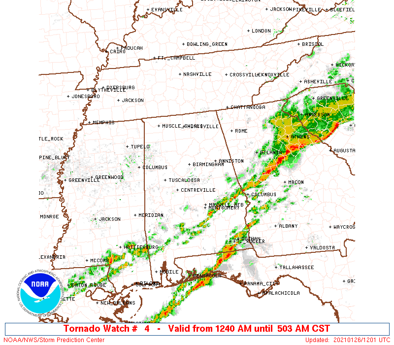
Tornado Watch Number 4
NWS Storm Prediction Center Norman OK
1240 AM CST Tue Jan 26 2021
The NWS Storm Prediction Center has issued a
* Tornado Watch for portions of
Central and eastern Alabama
Northwestern Georgia
* Effective this Tuesday morning from 1240 AM until 600 AM CST.
* Primary threats include...
A couple tornadoes possible
Isolated damaging wind gusts to 70 mph possible
SUMMARY...A band of strong-severe thunderstorms with embedded
supercells will shift eastward over the watch area, offering tornado
and damaging-wind potential for at least a few more hours.
The tornado watch area is approximately along and 30 statute miles
either side of a line from 25 miles south of Tuscaloosa AL to 70
miles east northeast of Anniston AL. For a complete depiction of the
watch see the associated watch outline update (WOUS64 KWNS WOU4).
PRECAUTIONARY/PREPAREDNESS ACTIONS...
REMEMBER...A Tornado Watch means conditions are favorable for
tornadoes and severe thunderstorms in and close to the watch
area. Persons in these areas should be on the lookout for
threatening weather conditions and listen for later statements
and possible warnings.
&&
OTHER WATCH INFORMATION...CONTINUE...WW 3...
AVIATION...Tornadoes and a few severe thunderstorms with hail
surface and aloft to 1 inch. Extreme turbulence and surface wind
gusts to 60 knots. A few cumulonimbi with maximum tops to 450. Mean
storm motion vector 25035.
...Edwards
   SEL4

   URGENT - IMMEDIATE BROADCAST REQUESTED
   Tornado Watch Number 4
   NWS Storm Prediction Center Norman OK
   1240 AM CST Tue Jan 26 2021

   The NWS Storm Prediction Center has issued a

   * Tornado Watch for portions of
     Central and eastern Alabama
     Northwestern Georgia

   * Effective this Tuesday morning from 1240 AM until 600 AM CST.

   * Primary threats include...
     A couple tornadoes possible
     Isolated damaging wind gusts to 70 mph possible

   SUMMARY...A band of strong-severe thunderstorms with embedded
   supercells will shift eastward over the watch area, offering tornado
   and damaging-wind potential for at least a few more hours.

   The tornado watch area is approximately along and 30 statute miles
   either side of a line from 25 miles south of Tuscaloosa AL to 70
   miles east northeast of Anniston AL. For a complete depiction of the
   watch see the associated watch outline update (WOUS64 KWNS WOU4).

   PRECAUTIONARY/PREPAREDNESS ACTIONS...

   REMEMBER...A Tornado Watch means conditions are favorable for
   tornadoes and severe thunderstorms in and close to the watch
   area. Persons in these areas should be on the lookout for
   threatening weather conditions and listen for later statements
   and possible warnings.

   &&

   OTHER WATCH INFORMATION...CONTINUE...WW 3...

   AVIATION...Tornadoes and a few severe thunderstorms with hail
   surface and aloft to 1 inch. Extreme turbulence and surface wind
   gusts to 60 knots. A few cumulonimbi with maximum tops to 450. Mean
   storm motion vector 25035.

   ...Edwards
 Note:
The Aviation Watch (SAW) product is an approximation to the watch area.
The actual watch is depicted by the shaded areas.
Note:
The Aviation Watch (SAW) product is an approximation to the watch area.
The actual watch is depicted by the shaded areas.
SAW4
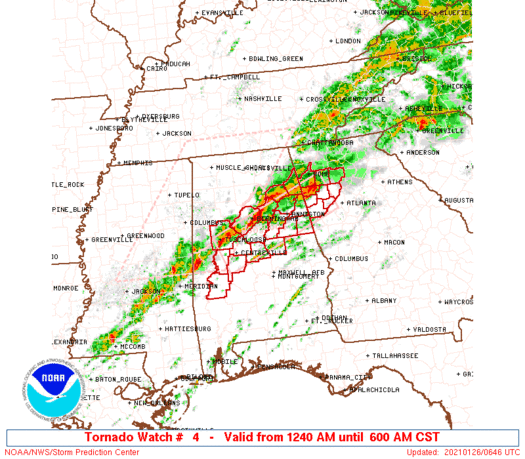
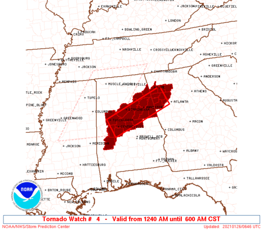
WW 4 TORNADO AL GA 260640Z - 261200Z
AXIS..30 STATUTE MILES EITHER SIDE OF LINE..
25S TCL/TUSCALOOSA AL/ - 70ENE ANB/ANNISTON AL/
..AVIATION COORDS.. 25NM EITHER SIDE /59SE IGB - 24NW ATL/
HAIL SURFACE AND ALOFT..1 INCH. WIND GUSTS..60 KNOTS.
MAX TOPS TO 450. MEAN STORM MOTION VECTOR 25035.
LAT...LON 33278779 34378490 33558455 32458745
THIS IS AN APPROXIMATION TO THE WATCH AREA. FOR A
COMPLETE DEPICTION OF THE WATCH SEE WOUS64 KWNS
FOR WOU4.
Watch 4 Status Report Messages:
STATUS REPORT #4 ON WW 4

VALID 261040Z - 261140Z

SEVERE WEATHER THREAT CONTINUES RIGHT OF A LINE FROM 30 SW SEM TO
25 NNW AUO TO 30 WSW ATL TO 5 ESE ATL.

..GLEASON..01/26/21

ATTN...WFO...BMX...FFC...

&&

STATUS REPORT FOR WT 4

SEVERE WEATHER THREAT CONTINUES FOR THE FOLLOWING AREAS

ALC111-261140-

AL
.    ALABAMA COUNTIES INCLUDED ARE

RANDOLPH
$$


THE WATCH STATUS MESSAGE IS FOR GUIDANCE PURPOSES ONLY.  PLEASE
REFER TO WATCH COUNTY NOTIFICATION STATEMENTS FOR OFFICIAL
INFORMATION ON COUNTIES...INDEPENDENT CITIES AND MARINE ZONES
CLEARED FROM SEVERE THUNDERSTORM AND TORNADO WATCHES.
$$

STATUS REPORT #3 ON WW 4

VALID 260930Z - 261040Z

SEVERE WEATHER THREAT CONTINUES RIGHT OF A LINE FROM 40 ESE MEI
TO 20 SSW ANB TO 35 NE ATL.

..GLEASON..01/26/21

ATTN...WFO...BMX...FFC...

&&

STATUS REPORT FOR WT 4

SEVERE WEATHER THREAT CONTINUES FOR THE FOLLOWING AREAS

ALC021-027-037-091-105-111-261040-

AL
.    ALABAMA COUNTIES INCLUDED ARE

CHILTON 	     CLAY		 COOSA
MARENGO 	     PERRY		 RANDOLPH
$$


GAC045-067-097-261040-

GA
.    GEORGIA COUNTIES INCLUDED ARE

CARROLL 	     COBB		 DOUGLAS
$$


THE WATCH STATUS MESSAGE IS FOR GUIDANCE PURPOSES ONLY.  PLEASE
REFER TO WATCH COUNTY NOTIFICATION STATEMENTS FOR OFFICIAL
INFORMATION ON COUNTIES...INDEPENDENT CITIES AND MARINE ZONES
CLEARED FROM SEVERE THUNDERSTORM AND TORNADO WATCHES.
$$

STATUS REPORT #2 ON WW 4

VALID 260825Z - 260940Z

SEVERE WEATHER THREAT CONTINUES RIGHT OF A LINE FROM 40 ESE MEI
TO 20 SSW TCL TO 55 NNE ATL.

FOR ADDITIONAL INFORMATION SEE MESOSCALE DISCUSSION 36

..GLEASON..01/26/21

ATTN...WFO...BMX...FFC...

&&

STATUS REPORT FOR WT 4

SEVERE WEATHER THREAT CONTINUES FOR THE FOLLOWING AREAS

ALC007-015-021-027-029-037-065-091-105-111-117-121-260940-

AL
.    ALABAMA COUNTIES INCLUDED ARE

BIBB		     CALHOUN		 CHILTON
CLAY		     CLEBURNE		 COOSA
HALE		     MARENGO		 PERRY
RANDOLPH	     SHELBY		 TALLADEGA
$$


GAC045-057-067-097-143-223-233-260940-

GA
.    GEORGIA COUNTIES INCLUDED ARE

CARROLL 	     CHEROKEE		 COBB
DOUGLAS 	     HARALSON		 PAULDING
POLK
$$


THE WATCH STATUS MESSAGE IS FOR GUIDANCE PURPOSES ONLY.  PLEASE
REFER TO WATCH COUNTY NOTIFICATION STATEMENTS FOR OFFICIAL
INFORMATION ON COUNTIES...INDEPENDENT CITIES AND MARINE ZONES
CLEARED FROM SEVERE THUNDERSTORM AND TORNADO WATCHES.
$$

STATUS REPORT #1 ON WW 4

VALID 260730Z - 260840Z

SEVERE WEATHER THREAT CONTINUES RIGHT OF A LINE FROM 35 NNE MEI
TO 20 SSW GAD TO 30 ENE RMG.

..GLEASON..01/26/21

ATTN...WFO...BMX...FFC...

&&

STATUS REPORT FOR WT 4

SEVERE WEATHER THREAT CONTINUES FOR THE FOLLOWING AREAS

ALC007-015-019-021-027-029-037-055-063-065-073-091-105-111-115-
117-119-121-125-260840-

AL
.    ALABAMA COUNTIES INCLUDED ARE

BIBB		     CALHOUN		 CHEROKEE
CHILTON 	     CLAY		 CLEBURNE
COOSA		     ETOWAH		 GREENE
HALE		     JEFFERSON		 MARENGO
PERRY		     RANDOLPH		 ST. CLAIR
SHELBY		     SUMTER		 TALLADEGA
TUSCALOOSA
$$


GAC015-045-057-067-097-115-143-223-233-260840-

GA
.    GEORGIA COUNTIES INCLUDED ARE

BARTOW		     CARROLL		 CHEROKEE
COBB		     DOUGLAS		 FLOYD
HARALSON	     PAULDING		 POLK
$$


THE WATCH STATUS MESSAGE IS FOR GUIDANCE PURPOSES ONLY.  PLEASE
REFER TO WATCH COUNTY NOTIFICATION STATEMENTS FOR OFFICIAL
INFORMATION ON COUNTIES...INDEPENDENT CITIES AND MARINE ZONES
CLEARED FROM SEVERE THUNDERSTORM AND TORNADO WATCHES.
$$
Note:
Click for Complete Product Text.
Tornadoes
Probability of 2 or more tornadoes
|
Mod (40%)
|
Probability of 1 or more strong (EF2-EF5) tornadoes
|
Low (20%)
|
Wind
Probability of 10 or more severe wind events
|
Low (20%)
|
Probability of 1 or more wind events > 65 knots
|
Low (20%)
|
Hail
Probability of 10 or more severe hail events
|
Low (<5%)
|
Probability of 1 or more hailstones > 2 inches
|
Low (<5%)
|
Combined Severe Hail/Wind
Probability of 6 or more combined severe hail/wind events
|
Mod (30%)
|
For each watch, probabilities for particular events inside the watch
(listed above in each table) are determined by the issuing forecaster.
The "Low" category contains probability values ranging from less than 2%
to 20% (EF2-EF5 tornadoes), less than 5% to 20% (all other probabilities),
"Moderate" from 30% to 60%, and "High" from 70% to greater than 95%.
High values are bolded and lighter in color to provide awareness of
an increased threat for a particular event.


 @NWSSPC