Note:
The expiration time in the watch graphic is amended if the watch is
replaced, cancelled or extended.
Note:
Note:
The expiration time in the watch graphic is amended if the watch is
replaced, cancelled or extended.
Note: Click for
Watch Status Reports.
SEL3
URGENT - IMMEDIATE BROADCAST REQUESTED
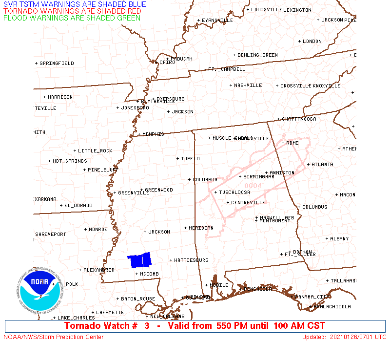
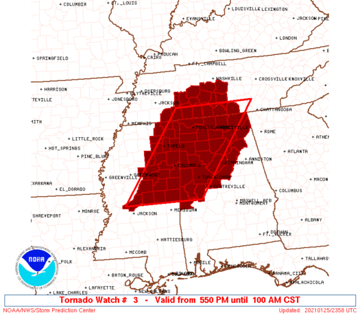
Tornado Watch Number 3
NWS Storm Prediction Center Norman OK
550 PM CST Mon Jan 25 2021
The NWS Storm Prediction Center has issued a
* Tornado Watch for portions of
Western and northern Alabama
East central and northeastern Mississippi
Much of southern Middle Tennessee
* Effective this Monday afternoon and Tuesday morning from 550 PM
until 100 AM CST.
* Primary threats include...
A few tornadoes possible
Scattered damaging wind gusts to 70 mph possible
Isolated large hail events to 1.5 inches in diameter possible
SUMMARY...Thunderstorms are expected to intensify gradually this
evening in broken pre-frontal bands from central/northeast
Mississippi into western/northern Alabama and southern Middle
Tennessee. The storm environment will favor supercells capable of
producing a few tornadoes, damaging gusts, and isolated large hail
into the overnight hours.
The tornado watch area is approximately along and 80 statute miles
east and west of a line from 80 miles south southwest of Columbus MS
to 50 miles north of Huntsville AL. For a complete depiction of the
watch see the associated watch outline update (WOUS64 KWNS WOU3).
PRECAUTIONARY/PREPAREDNESS ACTIONS...
REMEMBER...A Tornado Watch means conditions are favorable for
tornadoes and severe thunderstorms in and close to the watch
area. Persons in these areas should be on the lookout for
threatening weather conditions and listen for later statements
and possible warnings.
&&
AVIATION...Tornadoes and a few severe thunderstorms with hail
surface and aloft to 1.5 inches. Extreme turbulence and surface wind
gusts to 60 knots. A few cumulonimbi with maximum tops to 500. Mean
storm motion vector 24040.
...Thompson

   SEL3

   URGENT - IMMEDIATE BROADCAST REQUESTED
   Tornado Watch Number 3
   NWS Storm Prediction Center Norman OK
   550 PM CST Mon Jan 25 2021

   The NWS Storm Prediction Center has issued a

   * Tornado Watch for portions of
     Western and northern Alabama
     East central and northeastern Mississippi
     Much of southern Middle Tennessee

   * Effective this Monday afternoon and Tuesday morning from 550 PM
     until 100 AM CST.

   * Primary threats include...
     A few tornadoes possible
     Scattered damaging wind gusts to 70 mph possible
     Isolated large hail events to 1.5 inches in diameter possible

   SUMMARY...Thunderstorms are expected to intensify gradually this
   evening in broken pre-frontal bands from central/northeast
   Mississippi into western/northern Alabama and southern Middle
   Tennessee.  The storm environment will favor supercells capable of
   producing a few tornadoes, damaging gusts, and isolated large hail
   into the overnight hours.

   The tornado watch area is approximately along and 80 statute miles
   east and west of a line from 80 miles south southwest of Columbus MS
   to 50 miles north of Huntsville AL. For a complete depiction of the
   watch see the associated watch outline update (WOUS64 KWNS WOU3).

   PRECAUTIONARY/PREPAREDNESS ACTIONS...

   REMEMBER...A Tornado Watch means conditions are favorable for
   tornadoes and severe thunderstorms in and close to the watch
   area. Persons in these areas should be on the lookout for
   threatening weather conditions and listen for later statements
   and possible warnings.

   &&

   AVIATION...Tornadoes and a few severe thunderstorms with hail
   surface and aloft to 1.5 inches. Extreme turbulence and surface wind
   gusts to 60 knots. A few cumulonimbi with maximum tops to 500. Mean
   storm motion vector 24040.

   ...Thompson
 Note:
The Aviation Watch (SAW) product is an approximation to the watch area.
The actual watch is depicted by the shaded areas.
Note:
The Aviation Watch (SAW) product is an approximation to the watch area.
The actual watch is depicted by the shaded areas.
   SAW3
   WW 3 TORNADO AL MS TN 252350Z - 260700Z
   AXIS..80 STATUTE MILES EAST AND WEST OF LINE..
   80SSW CBM/COLUMBUS MS/ - 50N HSV/HUNTSVILLE AL/
   ..AVIATION COORDS.. 70NM E/W /14NW MEI - 46S BNA/
   HAIL SURFACE AND ALOFT..1.5 INCHES. WIND GUSTS..60 KNOTS.
   MAX TOPS TO 500. MEAN STORM MOTION VECTOR 24040.

   LAT...LON 32559035 35378820 35378536 32558760

   THIS IS AN APPROXIMATION TO THE WATCH AREA.  FOR A
   COMPLETE DEPICTION OF THE WATCH SEE WOUS64 KWNS
   FOR WOU3.
Watch 3 Status Report Messages:
STATUS REPORT #3 ON WW 3

VALID 260625Z - 260740Z

SEVERE WEATHER THREAT CONTINUES RIGHT OF A LINE FROM 15 NNE MEI
TO 20 N BHM TO 10 SW RMG.

FOR ADDITIONAL INFORMATION SEE MESOSCALE DISCUSSION 35

..GLEASON..01/26/21

ATTN...WFO...BMX...HUN...MEG...JAN...OHX...

&&

STATUS REPORT FOR WT 3

SEVERE WEATHER THREAT CONTINUES FOR THE FOLLOWING AREAS

ALC007-009-015-019-029-055-063-065-073-115-117-119-121-125-
260740-

AL
.    ALABAMA COUNTIES INCLUDED ARE

BIBB		     BLOUNT		 CALHOUN
CHEROKEE	     CLEBURNE		 ETOWAH
GREENE		     HALE		 JEFFERSON
ST. CLAIR	     SHELBY		 SUMTER
TALLADEGA	     TUSCALOOSA
$$


THE WATCH STATUS MESSAGE IS FOR GUIDANCE PURPOSES ONLY.  PLEASE
REFER TO WATCH COUNTY NOTIFICATION STATEMENTS FOR OFFICIAL
INFORMATION ON COUNTIES...INDEPENDENT CITIES AND MARINE ZONES
CLEARED FROM SEVERE THUNDERSTORM AND TORNADO WATCHES.
$$

STATUS REPORT #2 ON WW 3

VALID 260345Z - 260440Z

SEVERE WEATHER THREAT CONTINUES RIGHT OF A LINE FROM 65 S GWO TO
10 NE CBM TO 50 NNE MSL.

..SPC..01/26/21

ATTN...WFO...BMX...HUN...MEG...JAN...OHX...

&&

STATUS REPORT FOR WT 3

SEVERE WEATHER THREAT CONTINUES FOR THE FOLLOWING AREAS

ALC007-009-033-043-049-055-057-059-063-065-071-073-075-077-079-
083-089-093-095-103-107-115-117-119-125-127-133-260440-

AL
.    ALABAMA COUNTIES INCLUDED ARE

BIBB		     BLOUNT		 COLBERT
CULLMAN 	     DEKALB		 ETOWAH
FAYETTE 	     FRANKLIN		 GREENE
HALE		     JACKSON		 JEFFERSON
LAMAR		     LAUDERDALE 	 LAWRENCE
LIMESTONE	     MADISON		 MARION
MARSHALL	     MORGAN		 PICKENS
ST. CLAIR	     SHELBY		 SUMTER
TUSCALOOSA	     WALKER		 WINSTON
$$


MSC069-079-087-099-103-159-260440-

MS
.    MISSISSIPPI COUNTIES INCLUDED ARE

KEMPER		     LEAKE		 LOWNDES
NESHOBA 	     NOXUBEE		 WINSTON
$$


TNC003-051-055-103-117-127-149-260440-

TN
.    TENNESSEE COUNTIES INCLUDED ARE

BEDFORD 	     FRANKLIN		 GILES
LINCOLN 	     MARSHALL		 MOORE
RUTHERFORD
$$


THE WATCH STATUS MESSAGE IS FOR GUIDANCE PURPOSES ONLY.  PLEASE
REFER TO WATCH COUNTY NOTIFICATION STATEMENTS FOR OFFICIAL
INFORMATION ON COUNTIES...INDEPENDENT CITIES AND MARINE ZONES
CLEARED FROM SEVERE THUNDERSTORM AND TORNADO WATCHES.
$$

STATUS REPORT #1 ON WW 3

VALID 260055Z - 260140Z

THE SEVERE WEATHER THREAT CONTINUES ACROSS THE ENTIRE WATCH AREA.

..SPC..01/26/21

ATTN...WFO...BMX...HUN...MEG...JAN...OHX...

&&

STATUS REPORT FOR WT 3

SEVERE WEATHER THREAT CONTINUES FOR THE FOLLOWING AREAS

ALC007-009-033-043-049-055-057-059-063-065-071-073-075-077-079-
083-089-093-095-103-107-115-117-119-125-127-133-260140-

AL
.    ALABAMA COUNTIES INCLUDED ARE

BIBB		     BLOUNT		 COLBERT
CULLMAN 	     DEKALB		 ETOWAH
FAYETTE 	     FRANKLIN		 GREENE
HALE		     JACKSON		 JEFFERSON
LAMAR		     LAUDERDALE 	 LAWRENCE
LIMESTONE	     MADISON		 MARION
MARSHALL	     MORGAN		 PICKENS
ST. CLAIR	     SHELBY		 SUMTER
TUSCALOOSA	     WALKER		 WINSTON
$$


MSC003-007-013-017-019-025-057-069-079-081-087-089-095-097-099-
103-105-115-117-139-141-145-155-159-260140-

MS
.    MISSISSIPPI COUNTIES INCLUDED ARE

ALCORN		     ATTALA		 CALHOUN
CHICKASAW	     CHOCTAW		 CLAY
ITAWAMBA	     KEMPER		 LEAKE
LEE		     LOWNDES		 MADISON
MONROE		     MONTGOMERY 	 NESHOBA
NOXUBEE 	     OKTIBBEHA		 PONTOTOC
PRENTISS	     TIPPAH		 TISHOMINGO
UNION		     WEBSTER		 WINSTON
$$


TNC003-039-051-055-071-081-099-101-103-109-117-119-127-135-149-
181-187-260140-

TN
.    TENNESSEE COUNTIES INCLUDED ARE

BEDFORD 	     DECATUR		 FRANKLIN
GILES		     HARDIN		 HICKMAN
LAWRENCE	     LEWIS		 LINCOLN
MCNAIRY 	     MARSHALL		 MAURY
MOORE		     PERRY		 RUTHERFORD
WAYNE		     WILLIAMSON
$$


THE WATCH STATUS MESSAGE IS FOR GUIDANCE PURPOSES ONLY.  PLEASE
REFER TO WATCH COUNTY NOTIFICATION STATEMENTS FOR OFFICIAL
INFORMATION ON COUNTIES...INDEPENDENT CITIES AND MARINE ZONES
CLEARED FROM SEVERE THUNDERSTORM AND TORNADO WATCHES.
$$
Note:
Click for Complete Product Text.
Tornadoes
Probability of 2 or more tornadoes
|
Mod (50%)
|
Probability of 1 or more strong (EF2-EF5) tornadoes
|
Low (20%)
|
Wind
Probability of 10 or more severe wind events
|
Mod (40%)
|
Probability of 1 or more wind events > 65 knots
|
Low (20%)
|
Hail
Probability of 10 or more severe hail events
|
Mod (30%)
|
Probability of 1 or more hailstones > 2 inches
|
Low (10%)
|
Combined Severe Hail/Wind
Probability of 6 or more combined severe hail/wind events
|
High (70%)
|
For each watch, probabilities for particular events inside the watch
(listed above in each table) are determined by the issuing forecaster.
The "Low" category contains probability values ranging from less than 2%
to 20% (EF2-EF5 tornadoes), less than 5% to 20% (all other probabilities),
"Moderate" from 30% to 60%, and "High" from 70% to greater than 95%.
High values are bolded and lighter in color to provide awareness of
an increased threat for a particular event.


 @NWSSPC