 Note:
The expiration time in the watch graphic is amended if the watch is
replaced, cancelled or extended.
Note:
Note:
The expiration time in the watch graphic is amended if the watch is
replaced, cancelled or extended.
Note: Click for
Watch Status Reports.
SEL7
URGENT - IMMEDIATE BROADCAST REQUESTED
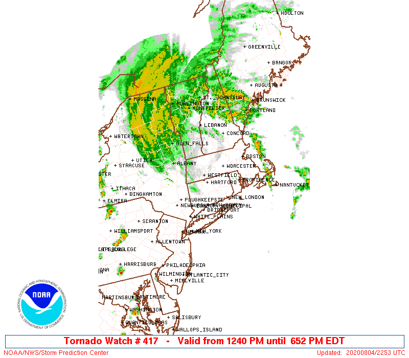
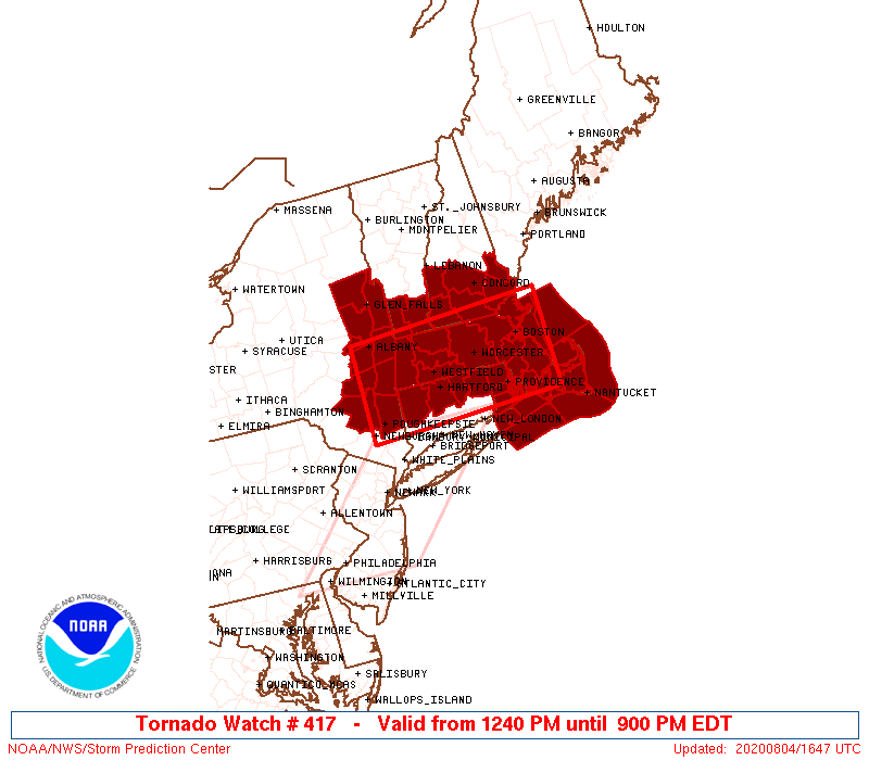
Tornado Watch Number 417
NWS Storm Prediction Center Norman OK
1240 PM EDT Tue Aug 4 2020
The NWS Storm Prediction Center has issued a
* Tornado Watch for portions of
northern Connecticut
Massachusetts
southern New Hampshire
eastern New York
northern Rhode Island
southern Vermont
Coastal Waters
* Effective this Tuesday afternoon and evening from 1240 PM until
900 PM EDT.
* Primary threats include...
A few tornadoes possible
Isolated significant damaging wind gusts to 80 mph possible
SUMMARY...In association with the north-northeastward progression of
Isaias, thunderstorm activity will form and spread northward across
the region this afternoon through early evening, in an environment
conducive to the development of a few tornadoes.
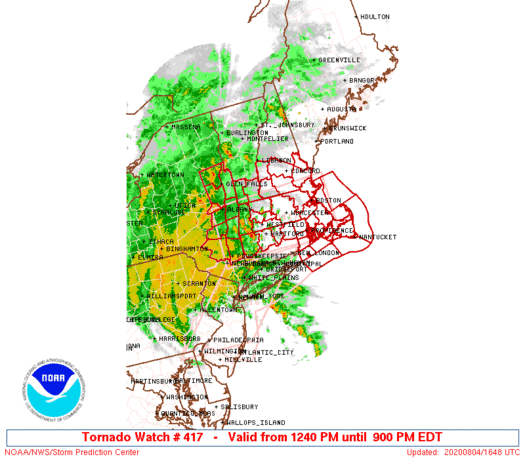
The tornado watch area is approximately along and 50 statute miles
north and south of a line from 35 miles north northwest of
Poughkeepsie NY to 30 miles east southeast of Boston MA. For a
complete depiction of the watch see the associated watch outline
update (WOUS64 KWNS WOU7).
PRECAUTIONARY/PREPAREDNESS ACTIONS...
REMEMBER...A Tornado Watch means conditions are favorable for
tornadoes and severe thunderstorms in and close to the watch
area. Persons in these areas should be on the lookout for
threatening weather conditions and listen for later statements
and possible warnings.
&&
OTHER WATCH INFORMATION...CONTINUE...WW 416...
AVIATION...Tornadoes and a few severe thunderstorms with hail
surface and aloft to 0 inches. Extreme turbulence and surface wind
gusts to 70 knots. A few cumulonimbi with maximum tops to 450. Mean
storm motion vector 17035.
...Kerr

   SEL7

   URGENT - IMMEDIATE BROADCAST REQUESTED
   Tornado Watch Number 417
   NWS Storm Prediction Center Norman OK
   1240 PM EDT Tue Aug 4 2020

   The NWS Storm Prediction Center has issued a

   * Tornado Watch for portions of
     northern Connecticut
     Massachusetts
     southern New Hampshire
     eastern New York
     northern Rhode Island
     southern Vermont
     Coastal Waters

   * Effective this Tuesday afternoon and evening from 1240 PM until
     900 PM EDT.

   * Primary threats include...
     A few tornadoes possible
     Isolated significant damaging wind gusts to 80 mph possible

   SUMMARY...In association with the north-northeastward progression of
   Isaias, thunderstorm activity will form and spread northward across
   the region this afternoon through early evening, in an environment
   conducive to the development of a few tornadoes.

   The tornado watch area is approximately along and 50 statute miles
   north and south of a line from 35 miles north northwest of
   Poughkeepsie NY to 30 miles east southeast of Boston MA. For a
   complete depiction of the watch see the associated watch outline
   update (WOUS64 KWNS WOU7).

   PRECAUTIONARY/PREPAREDNESS ACTIONS...

   REMEMBER...A Tornado Watch means conditions are favorable for
   tornadoes and severe thunderstorms in and close to the watch
   area. Persons in these areas should be on the lookout for
   threatening weather conditions and listen for later statements
   and possible warnings.

   &&

   OTHER WATCH INFORMATION...CONTINUE...WW 416...

   AVIATION...Tornadoes and a few severe thunderstorms with hail
   surface and aloft to 0 inches. Extreme turbulence and surface wind
   gusts to 70 knots. A few cumulonimbi with maximum tops to 450. Mean
   storm motion vector 17035.

   ...Kerr
 Note:
The Aviation Watch (SAW) product is an approximation to the watch area.
The actual watch is depicted by the shaded areas.
Note:
The Aviation Watch (SAW) product is an approximation to the watch area.
The actual watch is depicted by the shaded areas.
   SAW7
   WW 417 TORNADO CT MA NH NY RI VT CW 041640Z - 050100Z
   AXIS..50 STATUTE MILES NORTH AND SOUTH OF LINE..
   35NNW POU/POUGHKEEPSIE NY/ - 30ESE BOS/BOSTON MA/
   ..AVIATION COORDS.. 45NM N/S /42SSW ALB - 25ESE BOS/
   WIND GUSTS..70 KNOTS.
   MAX TOPS TO 450.MEAN STORM MOTION VECTOR 17035.

   LAT...LON 42827414 42937046 41487046 41377414

   THIS IS AN APPROXIMATION TO THE WATCH AREA.  FOR A
   COMPLETE DEPICTION OF THE WATCH SEE WOUS64 KWNS
   FOR WOU7.
Watch 417 Status Report Messages:
STATUS REPORT #3 ON WW 417

VALID 042350Z - 050040Z

SEVERE WEATHER THREAT CONTINUES RIGHT OF A LINE FROM 35 SW ACK TO
25 ESE BOS TO PSM.

..BROYLES..08/04/20

ATTN...WFO...BOX...ALY...GYX...

&&

STATUS REPORT FOR WT 417

SEVERE WEATHER THREAT CONTINUES FOR THE FOLLOWING AREAS

MAC001-019-050040-

MA
.    MASSACHUSETTS COUNTIES INCLUDED ARE

BARNSTABLE	     NANTUCKET
$$


ANZ231-250-254-255-050040-

CW

.    ADJACENT COASTAL WATERS INCLUDED ARE

CAPE COD BAY

COASTAL WATERS EAST OF IPSWICH BAY AND THE STELLWAGEN BANK
NATIONAL MARINE SANCTUARY

COASTAL WATERS FROM PROVINCETOWN MA TO CHATHAM MA TO NANTUCKET MA
OUT 20 NM

COASTAL WATERS EXTENDING OUT TO 25 NM SOUTH OF MARTHAS VINEYARD
AND NANTUCKET

$$
THE WATCH STATUS MESSAGE IS FOR GUIDANCE PURPOSES ONLY.  PLEASE
REFER TO WATCH COUNTY NOTIFICATION STATEMENTS FOR OFFICIAL
INFORMATION ON COUNTIES...INDEPENDENT CITIES AND MARINE ZONES
CLEARED FROM SEVERE THUNDERSTORM AND TORNADO WATCHES.
$$

STATUS REPORT #2 ON WW 417

VALID 042130Z - 042240Z

SEVERE WEATHER THREAT CONTINUES RIGHT OF A LINE FROM 40 SE BID TO
25 ESE ORH TO 20 SE RUT.

..HART..08/04/20

ATTN...WFO...BOX...ALY...GYX...

&&

STATUS REPORT FOR WT 417

SEVERE WEATHER THREAT CONTINUES FOR THE FOLLOWING AREAS

MAC001-005-007-009-017-019-021-023-025-042240-

MA
.    MASSACHUSETTS COUNTIES INCLUDED ARE

BARNSTABLE	     BRISTOL		 DUKES
ESSEX		     MIDDLESEX		 NANTUCKET
NORFOLK 	     PLYMOUTH		 SUFFOLK
$$


NHC005-011-013-015-017-019-042240-

NH
.    NEW HAMPSHIRE COUNTIES INCLUDED ARE

CHESHIRE	     HILLSBOROUGH	 MERRIMACK
ROCKINGHAM	     STRAFFORD		 SULLIVAN
$$


ANZ230-231-232-233-234-235-250-251-254-255-256-042240-

CW

.    ADJACENT COASTAL WATERS INCLUDED ARE

BOSTON HARBOR

CAPE COD BAY

NANTUCKET SOUND

VINEYARD SOUND

BUZZARDS BAY

RHODE ISLAND SOUND

COASTAL WATERS EAST OF IPSWICH BAY AND THE STELLWAGEN BANK
NATIONAL MARINE SANCTUARY

MASSACHUSETTS BAY AND IPSWICH BAY

COASTAL WATERS FROM PROVINCETOWN MA TO CHATHAM MA TO NANTUCKET MA
OUT 20 NM

COASTAL WATERS EXTENDING OUT TO 25 NM SOUTH OF MARTHAS VINEYARD
AND NANTUCKET

COASTAL WATERS FROM MONTAUK NY TO MARTHAS VINEYARD EXTENDING OUT
TO 20 NM SOUTH OF BLOCK ISLAND

$$
THE WATCH STATUS MESSAGE IS FOR GUIDANCE PURPOSES ONLY.  PLEASE
REFER TO WATCH COUNTY NOTIFICATION STATEMENTS FOR OFFICIAL
INFORMATION ON COUNTIES...INDEPENDENT CITIES AND MARINE ZONES
CLEARED FROM SEVERE THUNDERSTORM AND TORNADO WATCHES.
$$

STATUS REPORT #1 ON WW 417

VALID 042040Z - 042140Z

SEVERE WEATHER THREAT CONTINUES RIGHT OF A LINE FROM 15 WNW GON
TO 15 ENE ALB.

..MOSIER..08/04/20

ATTN...WFO...BOX...ALY...GYX...

&&

STATUS REPORT FOR WT 417

SEVERE WEATHER THREAT CONTINUES FOR THE FOLLOWING AREAS

CTC013-015-042140-

CT
.    CONNECTICUT COUNTIES INCLUDED ARE

TOLLAND 	     WINDHAM
$$


MAC001-005-007-009-011-013-015-017-019-021-023-025-027-042140-

MA
.    MASSACHUSETTS COUNTIES INCLUDED ARE

BARNSTABLE	     BRISTOL		 DUKES
ESSEX		     FRANKLIN		 HAMPDEN
HAMPSHIRE	     MIDDLESEX		 NANTUCKET
NORFOLK 	     PLYMOUTH		 SUFFOLK
WORCESTER
$$


NHC005-011-013-015-017-019-042140-

NH
.    NEW HAMPSHIRE COUNTIES INCLUDED ARE

CHESHIRE	     HILLSBOROUGH	 MERRIMACK
ROCKINGHAM	     STRAFFORD		 SULLIVAN
$$


RIC001-003-005-007-009-042140-

RI
.    RHODE ISLAND COUNTIES INCLUDED ARE

BRISTOL 	     KENT		 NEWPORT
PROVIDENCE	     WASHINGTON
$$


VTC003-025-042140-

VT
.    VERMONT COUNTIES INCLUDED ARE

BENNINGTON	     WINDHAM
$$


ANZ230-231-232-233-234-235-236-237-250-251-254-255-256-042140-

CW

.    ADJACENT COASTAL WATERS INCLUDED ARE

BOSTON HARBOR

CAPE COD BAY

NANTUCKET SOUND

VINEYARD SOUND

BUZZARDS BAY

RHODE ISLAND SOUND

NARRAGANSETT BAY

BLOCK ISLAND SOUND

COASTAL WATERS EAST OF IPSWICH BAY AND THE STELLWAGEN BANK
NATIONAL MARINE SANCTUARY

MASSACHUSETTS BAY AND IPSWICH BAY

COASTAL WATERS FROM PROVINCETOWN MA TO CHATHAM MA TO NANTUCKET MA
OUT 20 NM

COASTAL WATERS EXTENDING OUT TO 25 NM SOUTH OF MARTHAS VINEYARD
AND NANTUCKET

COASTAL WATERS FROM MONTAUK NY TO MARTHAS VINEYARD EXTENDING OUT
TO 20 NM SOUTH OF BLOCK ISLAND

$$
THE WATCH STATUS MESSAGE IS FOR GUIDANCE PURPOSES ONLY.  PLEASE
REFER TO WATCH COUNTY NOTIFICATION STATEMENTS FOR OFFICIAL
INFORMATION ON COUNTIES...INDEPENDENT CITIES AND MARINE ZONES
CLEARED FROM SEVERE THUNDERSTORM AND TORNADO WATCHES.
$$
Note:
Click for Complete Product Text.
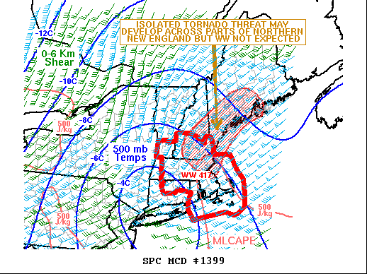
Tornadoes
Probability of 2 or more tornadoes
|
Mod (50%)
|
Probability of 1 or more strong (EF2-EF5) tornadoes
|
Low (20%)
|
Wind
Probability of 10 or more severe wind events
|
Mod (30%)
|
Probability of 1 or more wind events > 65 knots
|
Mod (30%)
|
Hail
Probability of 10 or more severe hail events
|
Low (<5%)
|
Probability of 1 or more hailstones > 2 inches
|
Low (<5%)
|
Combined Severe Hail/Wind
Probability of 6 or more combined severe hail/wind events
|
Mod (40%)
|
For each watch, probabilities for particular events inside the watch
(listed above in each table) are determined by the issuing forecaster.
The "Low" category contains probability values ranging from less than 2%
to 20% (EF2-EF5 tornadoes), less than 5% to 20% (all other probabilities),
"Moderate" from 30% to 60%, and "High" from 70% to greater than 95%.
High values are bolded and lighter in color to provide awareness of
an increased threat for a particular event.


 @NWSSPC