|
| Mesoscale Discussion 1399 |
|
< Previous MD Next MD >
|
|
Mesoscale Discussion 1399
NWS Storm Prediction Center Norman OK
0444 PM CDT Tue Aug 04 2020
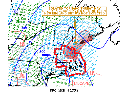
Areas affected...New England
Concerning...Tornado Watch 417...
Valid 042144Z - 042345Z
The severe weather threat for Tornado Watch 417 continues.
SUMMARY...An isolated tornado threat may develop across parts of New
England to the north of Tornado Watch 417 over the next few hours.
The threat is expected to be too marginal for weather watch
issuance.
DISCUSSION...Tropical Storm Isaias is currently located in southeast
New York. A distinct band of heavy rainfall is ongoing in the
northeast quadrant of Isaias from southern Vermont extending
southeastward into eastern Massachusetts. This band consists of
several discrete cells that are moving quickly northward across the
northern part of WW 417. This convection will move into southern
Maine and across Vermont and New Hampshire. The WSR-88D VWP at Gray,
Maine shows easterly surface winds with gradually veering winds to
the south-southeast at 3 km above ground. This combined with speed
shear in the low-levels is creating 0-3 km storm relative helicities
near 500 m2/s2. However, further to the north, the airmass is less
unstable and surface dewpoints are only in the 60s F. Therefore, any
tornado threat with the stronger rotating cells within the line
should remain marginal.
..Broyles/Hart.. 08/04/2020
...Please see www.spc.noaa.gov for graphic product...
ATTN...WFO...CAR...GYX...BOX...
LAT...LON 42137074 42947022 43506969 43856914 44066861 44376849
44666869 44866899 44986937 44797003 44097116 43637176
43277208 42787209 42287134 42137074
|
|
Top/All Mesoscale Discussions/Forecast Products/Home
|
|


 @NWSSPC