Note:
The expiration time in the watch graphic is amended if the watch is
replaced, cancelled or extended.
Note:
Note:
The expiration time in the watch graphic is amended if the watch is
replaced, cancelled or extended.
Note: Click for
Watch Status Reports.
SEL5
URGENT - IMMEDIATE BROADCAST REQUESTED
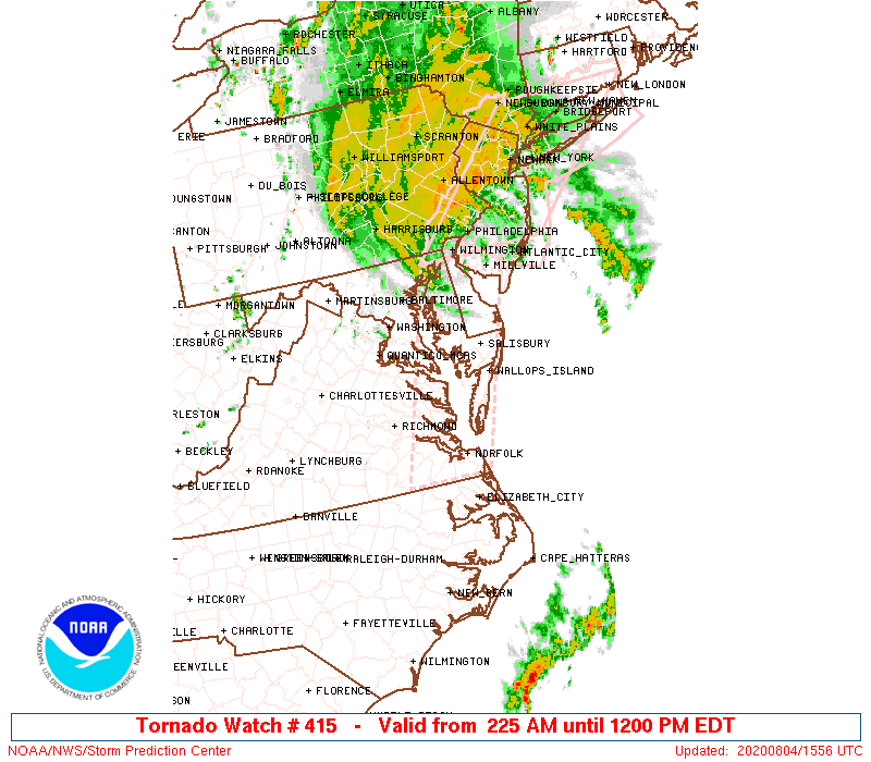
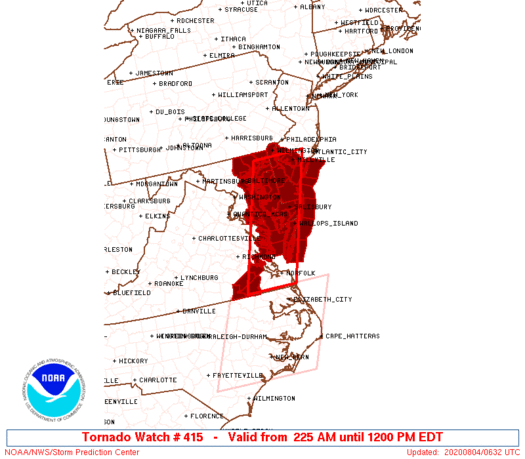
Tornado Watch Number 415
NWS Storm Prediction Center Norman OK
225 AM EDT Tue Aug 4 2020
The NWS Storm Prediction Center has issued a
* Tornado Watch for portions of
Delaware
Eastern Maryland
Southern New Jersey
Southeast Virginia
Coastal Waters
* Effective this Tuesday morning from 225 AM until NOON EDT.
* Primary threats include...
A few tornadoes possible
SUMMARY...Multiple low-topped supercells associated with tropical
cyclone Isaias will spread north-northeast from northeast North
Carolina across the Virginia Tidewater, Chesapeake Bay, and the
Delmarva region this morning.
The tornado watch area is approximately along and 40 statute miles
east and west of a line from 30 miles north of Dover DE to 30 miles
southwest of Norfolk VA. For a complete depiction of the watch see
the associated watch outline update (WOUS64 KWNS WOU5).
PRECAUTIONARY/PREPAREDNESS ACTIONS...
REMEMBER...A Tornado Watch means conditions are favorable for
tornadoes and severe thunderstorms in and close to the watch
area. Persons in these areas should be on the lookout for
threatening weather conditions and listen for later statements
and possible warnings.
&&
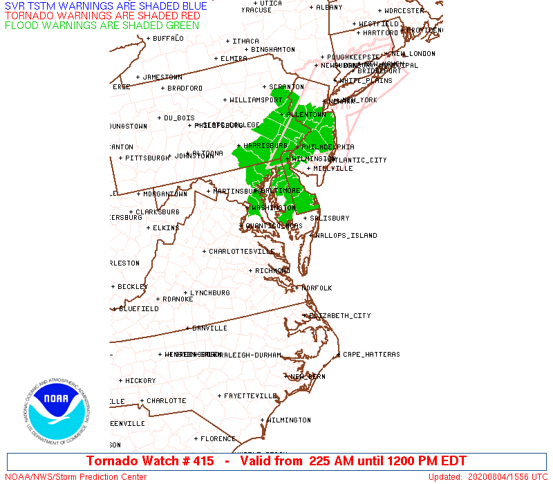
OTHER WATCH INFORMATION...CONTINUE...WW 414...
AVIATION...Tornadoes and a few severe thunderstorms with hail
surface and aloft to 0.5 inches. Extreme turbulence and surface wind
gusts to 55 knots. A few cumulonimbi with maximum tops to 400. Mean
storm motion vector 17045.
...Grams
   SEL5

   URGENT - IMMEDIATE BROADCAST REQUESTED
   Tornado Watch Number 415
   NWS Storm Prediction Center Norman OK
   225 AM EDT Tue Aug 4 2020

   The NWS Storm Prediction Center has issued a

   * Tornado Watch for portions of
     Delaware
     Eastern Maryland
     Southern New Jersey
     Southeast Virginia
     Coastal Waters

   * Effective this Tuesday morning from 225 AM until NOON EDT.

   * Primary threats include...
     A few tornadoes possible

   SUMMARY...Multiple low-topped supercells associated with tropical
   cyclone Isaias will spread north-northeast from northeast North
   Carolina across the Virginia Tidewater, Chesapeake Bay, and the
   Delmarva region this morning.

   The tornado watch area is approximately along and 40 statute miles
   east and west of a line from 30 miles north of Dover DE to 30 miles
   southwest of Norfolk VA. For a complete depiction of the watch see
   the associated watch outline update (WOUS64 KWNS WOU5).

   PRECAUTIONARY/PREPAREDNESS ACTIONS...

   REMEMBER...A Tornado Watch means conditions are favorable for
   tornadoes and severe thunderstorms in and close to the watch
   area. Persons in these areas should be on the lookout for
   threatening weather conditions and listen for later statements
   and possible warnings.

   &&

   OTHER WATCH INFORMATION...CONTINUE...WW 414...

   AVIATION...Tornadoes and a few severe thunderstorms with hail
   surface and aloft to 0.5 inches. Extreme turbulence and surface wind
   gusts to 55 knots. A few cumulonimbi with maximum tops to 400. Mean
   storm motion vector 17045.

   ...Grams
 Note:
The Aviation Watch (SAW) product is an approximation to the watch area.
The actual watch is depicted by the shaded areas.
Note:
The Aviation Watch (SAW) product is an approximation to the watch area.
The actual watch is depicted by the shaded areas.
   SAW5
   WW 415 TORNADO DE MD NJ VA CW 040625Z - 041600Z
   AXIS..40 STATUTE MILES EAST AND WEST OF LINE..
   30N DOV/DOVER DE/ - 30SW ORF/NORFOLK VA/
   ..AVIATION COORDS.. 35NM E/W /42NW SIE - 26SW ORF/
   HAIL SURFACE AND ALOFT..0.5 INCH. WIND GUSTS..55 KNOTS.
   MAX TOPS TO 400. MEAN STORM MOTION VECTOR 17045.

   LAT...LON 39567472 36597586 36597730 39567622

   THIS IS AN APPROXIMATION TO THE WATCH AREA.  FOR A
   COMPLETE DEPICTION OF THE WATCH SEE WOUS64 KWNS
   FOR WOU5.
Watch 415 Status Report Messages:
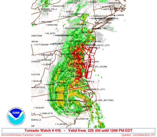
STATUS REPORT #3 ON WW 415
VALID 041230Z - 041340Z
SEVERE WEATHER THREAT CONTINUES RIGHT OF A LINE FROM 20 ESE WAL
TO 10 NW WAL TO 15 E NHK TO 25 WNW NHK.
FOR ADDITIONAL INFORMATION SEE MESOSCALE DISCUSSION 1393
..JEWELL..08/04/20
ATTN...WFO...PHI...LWX...AKQ...
&&
STATUS REPORT FOR WT 415
SEVERE WEATHER THREAT CONTINUES FOR THE FOLLOWING AREAS
DEC001-003-005-041340-
DE
. DELAWARE COUNTIES INCLUDED ARE
KENT NEW CASTLE SUSSEX
$$
MDC003-005-009-011-015-019-025-029-035-039-041-045-047-510-
041340-
MD
. MARYLAND COUNTIES INCLUDED ARE
ANNE ARUNDEL BALTIMORE CALVERT
CAROLINE CECIL DORCHESTER
HARFORD KENT QUEEN ANNE'S
SOMERSET TALBOT WICOMICO
WORCESTER
MARYLAND INDEPENDENT CITIES INCLUDED ARE
BALTIMORE CITY
$$
NJC009-011-033-041340-
NJ
. NEW JERSEY COUNTIES INCLUDED ARE
CAPE MAY CUMBERLAND SALEM
$$
ANZ430-431-453-454-455-530-531-532-533-538-539-540-541-542-543-
650-041340-
CW
. ADJACENT COASTAL WATERS INCLUDED ARE
DELAWARE BAY WATERS NORTH OF EAST POINT NJ TO SLAUGHTER BEACH DE
DELAWARE BAY WATERS SOUTH OF EAST POINT NJ TO SLAUGHTER BEACH DE
COASTAL WATERS FROM GREAT EGG INLET TO CAPE MAY NJ OUT 20 NM
COASTAL WATERS FROM CAPE MAY NJ TO CAPE HENLOPEN DE OUT 20 NM
COASTAL WATERS FROM CAPE HENLOPEN TO FENWICK ISLAND DE OUT 20 NM
CHESAPEAKE BAY NORTH OF POOLES ISLAND MD
CHESAPEAKE BAY FROM POOLES ISLAND TO SANDY POINT MD
CHESAPEAKE BAY FROM SANDY POINT TO NORTH BEACH MD
CHESAPEAKE BAY FROM NORTH BEACH TO DRUM POINT MD
PATAPSCO RIVER INCLUDING BALTIMORE HARBOR
CHESTER RIVER TO QUEENSTOWN MD
EASTERN BAY
CHOPTANK RIVER TO CAMBRIDGE MD AND THE LITTLE CHOPTANK RIVER
PATUXENT RIVER TO BROOMES ISLAND MD
TANGIER SOUND AND THE INLAND WATERS SURROUNDING BLOODSWORTH
ISLAND
COASTAL WATERS FROM FENWICK ISLAND DE TO CHINCOTEAGUE VA OUT 20
NM
$$
THE WATCH STATUS MESSAGE IS FOR GUIDANCE PURPOSES ONLY. PLEASE
REFER TO WATCH COUNTY NOTIFICATION STATEMENTS FOR OFFICIAL
INFORMATION ON COUNTIES...INDEPENDENT CITIES AND MARINE ZONES
CLEARED FROM SEVERE THUNDERSTORM AND TORNADO WATCHES.
$$
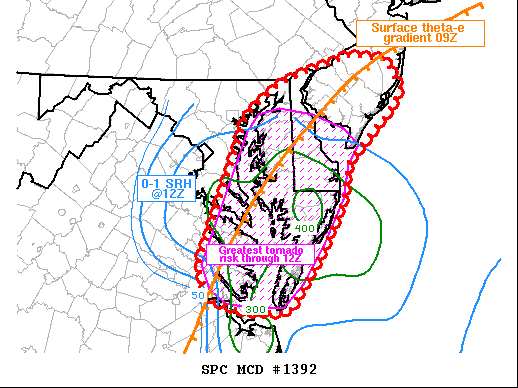
STATUS REPORT #2 ON WW 415
VALID 040950Z - 041040Z
SEVERE WEATHER THREAT CONTINUES RIGHT OF A LINE FROM 35 ENE ORF
TO 45 N ORF TO 40 ENE RIC TO 15 NE RIC TO 5 NW RIC.
FOR ADDITIONAL INFORMATION SEE MESOSCALE DISCUSSION 1392
..JEWELL..08/04/20
ATTN...WFO...PHI...LWX...AKQ...
&&
STATUS REPORT FOR WT 415
SEVERE WEATHER THREAT CONTINUES FOR THE FOLLOWING AREAS
DEC001-003-005-041040-
DE
. DELAWARE COUNTIES INCLUDED ARE
KENT NEW CASTLE SUSSEX
$$
MDC003-005-009-011-015-019-025-029-035-037-039-041-045-047-510-
041040-
MD
. MARYLAND COUNTIES INCLUDED ARE
ANNE ARUNDEL BALTIMORE CALVERT
CAROLINE CECIL DORCHESTER
HARFORD KENT QUEEN ANNE'S
ST. MARYS SOMERSET TALBOT
WICOMICO WORCESTER
MARYLAND INDEPENDENT CITIES INCLUDED ARE
BALTIMORE CITY
$$
NJC009-011-033-041040-
NJ
. NEW JERSEY COUNTIES INCLUDED ARE
CAPE MAY CUMBERLAND SALEM
$$
VAC001-057-097-101-103-119-131-133-159-193-041040-
VA
. VIRGINIA COUNTIES INCLUDED ARE
ACCOMACK ESSEX KING AND QUEEN
KING WILLIAM LANCASTER MIDDLESEX
NORTHAMPTON NORTHUMBERLAND RICHMOND
WESTMORELAND
$$
ANZ430-431-453-454-455-530-531-532-533-534-537-538-539-540-541-
542-543-630-631-635-650-652-654-041040-
CW
. ADJACENT COASTAL WATERS INCLUDED ARE
DELAWARE BAY WATERS NORTH OF EAST POINT NJ TO SLAUGHTER BEACH DE
DELAWARE BAY WATERS SOUTH OF EAST POINT NJ TO SLAUGHTER BEACH DE
COASTAL WATERS FROM GREAT EGG INLET TO CAPE MAY NJ OUT 20 NM
COASTAL WATERS FROM CAPE MAY NJ TO CAPE HENLOPEN DE OUT 20 NM
COASTAL WATERS FROM CAPE HENLOPEN TO FENWICK ISLAND DE OUT 20 NM
CHESAPEAKE BAY NORTH OF POOLES ISLAND MD
CHESAPEAKE BAY FROM POOLES ISLAND TO SANDY POINT MD
CHESAPEAKE BAY FROM SANDY POINT TO NORTH BEACH MD
CHESAPEAKE BAY FROM NORTH BEACH TO DRUM POINT MD
CHESAPEAKE BAY FROM DRUM POINT MD TO SMITH POINT VA
TIDAL POTOMAC FROM COBB ISLAND MD TO SMITH POINT VA
PATAPSCO RIVER INCLUDING BALTIMORE HARBOR
CHESTER RIVER TO QUEENSTOWN MD
EASTERN BAY
CHOPTANK RIVER TO CAMBRIDGE MD AND THE LITTLE CHOPTANK RIVER
PATUXENT RIVER TO BROOMES ISLAND MD
TANGIER SOUND AND THE INLAND WATERS SURROUNDING BLOODSWORTH
ISLAND
CHESAPEAKE BAY FROM SMITH POINT TO WINDMILL POINT VA
CHESAPEAKE BAY FROM WINDMILL POINT TO NEW POINT COMFORT VA
RAPPAHANNOCK RIVER FROM URBANNA TO WINDMILL POINT
COASTAL WATERS FROM FENWICK ISLAND DE TO CHINCOTEAGUE VA OUT 20
NM
COASTAL WATERS FROM CHINCOTEAGUE TO PARRAMORE ISLAND VA OUT 20 NM
COASTAL WATERS FROM PARRAMORE ISLAND TO CAPE CHARLES LIGHT VA OUT
20 NM
$$
THE WATCH STATUS MESSAGE IS FOR GUIDANCE PURPOSES ONLY. PLEASE
REFER TO WATCH COUNTY NOTIFICATION STATEMENTS FOR OFFICIAL
INFORMATION ON COUNTIES...INDEPENDENT CITIES AND MARINE ZONES
CLEARED FROM SEVERE THUNDERSTORM AND TORNADO WATCHES.
$$
STATUS REPORT #1 ON WW 415
VALID 040820Z - 040940Z
THE SEVERE WEATHER THREAT CONTINUES ACROSS THE ENTIRE WATCH AREA.
..JEWELL..08/04/20
ATTN...WFO...PHI...LWX...AKQ...
&&
STATUS REPORT FOR WT 415
SEVERE WEATHER THREAT CONTINUES FOR THE FOLLOWING AREAS
DEC001-003-005-040940-
DE
. DELAWARE COUNTIES INCLUDED ARE
KENT NEW CASTLE SUSSEX
$$
MDC003-005-009-011-015-019-025-029-035-037-039-041-045-047-510-
040940-
MD
. MARYLAND COUNTIES INCLUDED ARE
ANNE ARUNDEL BALTIMORE CALVERT
CAROLINE CECIL DORCHESTER
HARFORD KENT QUEEN ANNE'S
ST. MARYS SOMERSET TALBOT
WICOMICO WORCESTER
MARYLAND INDEPENDENT CITIES INCLUDED ARE
BALTIMORE CITY
$$
NJC009-011-033-040940-
NJ
. NEW JERSEY COUNTIES INCLUDED ARE
CAPE MAY CUMBERLAND SALEM
$$
VAC001-073-081-095-103-115-119-131-133-175-181-183-595-620-830-
040940-
VA
. VIRGINIA COUNTIES INCLUDED ARE
ACCOMACK GLOUCESTER GREENSVILLE
JAMES CITY LANCASTER MATHEWS
MIDDLESEX NORTHAMPTON NORTHUMBERLAND
SOUTHAMPTON SURRY SUSSEX
VIRGINIA INDEPENDENT CITIES INCLUDED ARE
EMPORIA FRANKLIN WILLIAMSBURG
$$
ANZ430-431-453-454-455-530-531-532-533-534-537-538-540-541-542-
543-630-631-635-636-650-652-654-040940-
CW
. ADJACENT COASTAL WATERS INCLUDED ARE
DELAWARE BAY WATERS NORTH OF EAST POINT NJ TO SLAUGHTER BEACH DE
DELAWARE BAY WATERS SOUTH OF EAST POINT NJ TO SLAUGHTER BEACH DE
COASTAL WATERS FROM GREAT EGG INLET TO CAPE MAY NJ OUT 20 NM
COASTAL WATERS FROM CAPE MAY NJ TO CAPE HENLOPEN DE OUT 20 NM
COASTAL WATERS FROM CAPE HENLOPEN TO FENWICK ISLAND DE OUT 20 NM
CHESAPEAKE BAY NORTH OF POOLES ISLAND MD
CHESAPEAKE BAY FROM POOLES ISLAND TO SANDY POINT MD
CHESAPEAKE BAY FROM SANDY POINT TO NORTH BEACH MD
CHESAPEAKE BAY FROM NORTH BEACH TO DRUM POINT MD
CHESAPEAKE BAY FROM DRUM POINT MD TO SMITH POINT VA
TIDAL POTOMAC FROM COBB ISLAND MD TO SMITH POINT VA
PATAPSCO RIVER INCLUDING BALTIMORE HARBOR
EASTERN BAY
CHOPTANK RIVER TO CAMBRIDGE MD AND THE LITTLE CHOPTANK RIVER
PATUXENT RIVER TO BROOMES ISLAND MD
TANGIER SOUND AND THE INLAND WATERS SURROUNDING BLOODSWORTH
ISLAND
CHESAPEAKE BAY FROM SMITH POINT TO WINDMILL POINT VA
CHESAPEAKE BAY FROM WINDMILL POINT TO NEW POINT COMFORT VA
RAPPAHANNOCK RIVER FROM URBANNA TO WINDMILL POINT
YORK RIVER
COASTAL WATERS FROM FENWICK ISLAND DE TO CHINCOTEAGUE VA OUT 20
NM
COASTAL WATERS FROM CHINCOTEAGUE TO PARRAMORE ISLAND VA OUT 20 NM
COASTAL WATERS FROM PARRAMORE ISLAND TO CAPE CHARLES LIGHT VA OUT
20 NM
$$
THE WATCH STATUS MESSAGE IS FOR GUIDANCE PURPOSES ONLY. PLEASE
REFER TO WATCH COUNTY NOTIFICATION STATEMENTS FOR OFFICIAL
INFORMATION ON COUNTIES...INDEPENDENT CITIES AND MARINE ZONES
CLEARED FROM SEVERE THUNDERSTORM AND TORNADO WATCHES.
$$
Note:
Click for Complete Product Text.
Tornadoes
Probability of 2 or more tornadoes
|
Mod (50%)
|
Probability of 1 or more strong (EF2-EF5) tornadoes
|
Low (10%)
|
Wind
Probability of 10 or more severe wind events
|
Low (10%)
|
Probability of 1 or more wind events > 65 knots
|
Low (10%)
|
Hail
Probability of 10 or more severe hail events
|
Low (<5%)
|
Probability of 1 or more hailstones > 2 inches
|
Low (<5%)
|
Combined Severe Hail/Wind
Probability of 6 or more combined severe hail/wind events
|
Low (20%)
|
For each watch, probabilities for particular events inside the watch
(listed above in each table) are determined by the issuing forecaster.
The "Low" category contains probability values ranging from less than 2%
to 20% (EF2-EF5 tornadoes), less than 5% to 20% (all other probabilities),
"Moderate" from 30% to 60%, and "High" from 70% to greater than 95%.
High values are bolded and lighter in color to provide awareness of
an increased threat for a particular event.


 @NWSSPC