|
| Mesoscale Discussion 1392 |
|
< Previous MD Next MD >
|
|
Mesoscale Discussion 1392
NWS Storm Prediction Center Norman OK
0415 AM CDT Tue Aug 04 2020
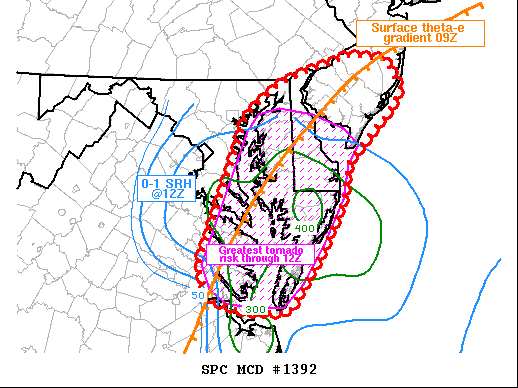
Areas affected...eastern Virginia into southern New Jersey
Concerning...Tornado Watch 415...
Valid 040915Z - 041215Z
The severe weather threat for Tornado Watch 415 continues.
SUMMARY...The threat of tornadoes will continue to spread north out
of southeast Virginia and into Maryland and Delaware.
DISCUSSION...Surface analysis shows strong pressure falls moving out
of northeast NC and into southeast VA, on the order of 3-4 mb/hr. A
band of supercells, tornadic at times, remains largely intact over
southeast VA.
To the north, sporadic small storms have been noted over the past
few hours, and have increased over the Delmarva recently. This is
likely due to pressure falls and low-level warm advection as wind
fields increase.
Over the next several hours, 0-1 SRH in excess of 300 m2/s2 will
spread north, possibly reaching far southern NJ around 12Z. As this
occurs, the environment will become increasingly favorable for
tornadoes with both cells ahead of the main arcing line of storms
and within the line itself.
..Jewell.. 08/04/2020
...Please see www.spc.noaa.gov for graphic product...
ATTN...WFO...PHI...AKQ...LWX...
LAT...LON 37817530 37117579 37097588 37117647 37247693 37617708
38287681 39337640 39697588 39997487 39947432 39617413
39327433 39137457 38777493 38367499 37817530
|
|
Top/All Mesoscale Discussions/Forecast Products/Home
|
|


 @NWSSPC