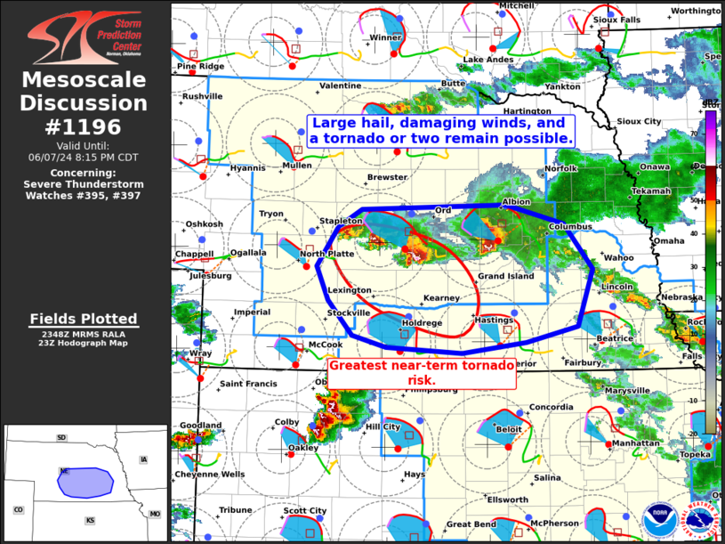
   Mesoscale Discussion 1196
   NWS Storm Prediction Center Norman OK
   0651 PM CDT Fri Jun 07 2024

   Areas affected...Portions of south-central Nebraska

   Concerning...Severe Thunderstorm Watch 395...397...

   Valid 072351Z - 080115Z

   The severe weather threat for Severe Thunderstorm Watch 395, 397
   continues.

   SUMMARY...Large hail, damaging winds, and a tornado or two remain
   possible with thunderstorms tracking south-southeastward across
   south-central Nebraska this evening.

   DISCUSSION...Latest radar data from KLNX indicates several
   discrete/semi-discrete supercells tracking south-southeastward
   across south-central Nebraska this evening. In particular, one
   longer-lived intense supercell currently over southeastern Custer
   County poses the greatest risk for large hail, damaging winds, and a
   tornado. Downstream of this storm, VWP data shows a large,
   clockwise-curved low-level hodograph (around 200 m2/s2 0-1 km SRH),
   which will support ample streamwise vorticity ingestion, given
   middle 60s dewpoints and moderate surface-based instability. This
   supercell may persist for another 60-90 minutes, with large hail up
   to 2.5 inches, locally damaging gusts up to 75 mph, and a tornado
   possible.

   Trailing supercell development along the outflow boundary will also
   pose a risk for large hail and damaging winds, and a brief tornado
   cannot be ruled out. Farther east over Nance County, a locally
   upscale-growing storm cluster is moving southeast at 30-35 kt, and
   this storm may pose a greater damaging-wind risk, with large hail
   also possible.

   ..Weinman/Majchrowski.. 06/07/2024

   ...Please see www.spc.noaa.gov for graphic product...

   ATTN...WFO...OAX...GID...LBF...

   LAT...LON   41490022 41669990 41729792 41519714 41059675 40469696
               40299765 40199853 40259955 40370001 40720035 41070050
               41490022
|


 @NWSSPC