Note:
The expiration time in the watch graphic is amended if the watch is
replaced, cancelled or extended.
Note:
Note:
The expiration time in the watch graphic is amended if the watch is
replaced, cancelled or extended.
Note: Click for
Watch Status Reports.
   SEL7

   URGENT - IMMEDIATE BROADCAST REQUESTED
   Severe Thunderstorm Watch Number 397
   NWS Storm Prediction Center Norman OK
   550 PM CDT Fri Jun 7 2024

   The NWS Storm Prediction Center has issued a

   * Severe Thunderstorm Watch for portions of
     Extreme Southwest Iowa
     Central and Northeast Kansas
     Northwest Missouri
     South central and Southeast Nebraska

   * Effective this Friday afternoon and evening from 550 PM until
     1100 PM CDT.

   * Primary threats include...
     Scattered damaging winds and isolated significant gusts to 75
       mph likely
     Scattered large hail and isolated very large hail events to 2.5
       inches in diameter likely
     A tornado or two possible

   SUMMARY...Severe thunderstorms are expected to increase in coverage
   while moving southeast across the watch area this evening. Damaging
   winds will become an increasing concern, with isolated gusts of up
   to 75 mph possible.  Large hail, possibly up to 2.5 inches in
   diameter, may occur with the strongest storms.  A tornado or two
   will also be possible within bowing segments as storms organize into
   a line.

   The severe thunderstorm watch area is approximately along and 85
   statute miles north and south of a line from 40 miles north of
   Russell KS to 15 miles south of Falls City NE. For a complete
   depiction of the watch see the associated watch outline update
   (WOUS64 KWNS WOU7).

   PRECAUTIONARY/PREPAREDNESS ACTIONS...

   REMEMBER...A Severe Thunderstorm Watch means conditions are
   favorable for severe thunderstorms in and close to the watch area.
   Persons in these areas should be on the lookout for threatening
   weather conditions and listen for later statements and possible
   warnings. Severe thunderstorms can and occasionally do produce
   tornadoes.

   &&

   OTHER WATCH INFORMATION...CONTINUE...WW 395...WW 396...

   AVIATION...A few severe thunderstorms with hail surface and aloft to
   2.5 inches. Extreme turbulence and surface wind gusts to 65 knots. A
   few cumulonimbi with maximum tops to 550. Mean storm motion vector
   30035.

   ...Bunting
 Note:
The Aviation Watch (SAW) product is an approximation to the watch area.
The actual watch is depicted by the shaded areas.
Note:
The Aviation Watch (SAW) product is an approximation to the watch area.
The actual watch is depicted by the shaded areas.
   SAW7
   WW 397 SEVERE TSTM IA KS MO NE 072250Z - 080400Z
   AXIS..85 STATUTE MILES NORTH AND SOUTH OF LINE..
   40N RSL/RUSSELL KS/ - 15S FNB/FALLS CITY NE/
   ..AVIATION COORDS.. 75NM N/S /64WNW SLN - 35SE PWE/
   HAIL SURFACE AND ALOFT..2.5 INCHES. WIND GUSTS..65 KNOTS.
   MAX TOPS TO 550. MEAN STORM MOTION VECTOR 30035.

   LAT...LON 40669882 41089560 38629560 38219882

   THIS IS AN APPROXIMATION TO THE WATCH AREA.  FOR A
   COMPLETE DEPICTION OF THE WATCH SEE WOUS64 KWNS
   FOR WOU7.
Watch 397 Status Report Messages:
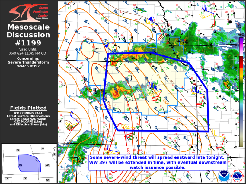
STATUS REPORT #4 ON WW 397

VALID 080330Z - 080440Z

SEVERE WEATHER THREAT CONTINUES RIGHT OF A LINE FROM 40 SW RSL TO
35 NE RSL TO 40 S HSI TO 30 WNW BIE TO 25 E SDA.

FOR ADDITIONAL INFORMATION SEE MESOSCALE DISCUSSION 1199

WW 397 WILL BE EXTENDED IN TIME TO 06Z.

..DEAN..06/08/24

ATTN...WFO...OAX...EAX...ICT...TOP...GID...

&&

STATUS REPORT FOR WS 397

SEVERE WEATHER THREAT CONTINUES FOR THE FOLLOWING AREAS

KSC005-009-013-017-027-029-041-043-053-061-085-087-089-105-111-
113-115-117-123-127-131-139-143-149-157-159-161-167-169-177-197-
201-080440-

KS
.    KANSAS COUNTIES INCLUDED ARE

ATCHISON	     BARTON		 BROWN
CHASE		     CLAY		 CLOUD
DICKINSON	     DONIPHAN		 ELLSWORTH
GEARY		     JACKSON		 JEFFERSON
JEWELL		     LINCOLN		 LYON
MCPHERSON	     MARION		 MARSHALL
MITCHELL	     MORRIS		 NEMAHA
OSAGE		     OTTAWA		 POTTAWATOMIE
REPUBLIC	     RICE		 RILEY
RUSSELL 	     SALINE		 SHAWNEE
WABAUNSEE	     WASHINGTON
$$


NEC067-095-097-127-129-133-147-169-080440-

NE
.    NEBRASKA COUNTIES INCLUDED ARE

GAGE		     JEFFERSON		 JOHNSON
NEMAHA		     NUCKOLLS		 PAWNEE
RICHARDSON	     THAYER
$$


THE WATCH STATUS MESSAGE IS FOR GUIDANCE PURPOSES ONLY.  PLEASE
REFER TO WATCH COUNTY NOTIFICATION STATEMENTS FOR OFFICIAL
INFORMATION ON COUNTIES...INDEPENDENT CITIES AND MARINE ZONES
CLEARED FROM SEVERE THUNDERSTORM AND TORNADO WATCHES.
$$

STATUS REPORT #3 ON WW 397

VALID 080230Z - 080340Z

THE SEVERE WEATHER THREAT CONTINUES ACROSS THE ENTIRE WATCH AREA.

FOR ADDITIONAL INFORMATION SEE MESOSCALE DISCUSSION 1198

..WEINMAN..06/08/24

ATTN...WFO...OAX...EAX...ICT...TOP...GID...

&&

STATUS REPORT FOR WS 397

SEVERE WEATHER THREAT CONTINUES FOR THE FOLLOWING AREAS

IAC071-080340-

IA
.    IOWA COUNTIES INCLUDED ARE

FREMONT
$$


KSC005-009-013-017-027-029-041-043-053-061-085-087-089-105-111-
113-115-117-123-127-131-139-141-143-147-149-157-159-161-163-167-
169-177-183-197-201-080340-

KS
.    KANSAS COUNTIES INCLUDED ARE

ATCHISON	     BARTON		 BROWN
CHASE		     CLAY		 CLOUD
DICKINSON	     DONIPHAN		 ELLSWORTH
GEARY		     JACKSON		 JEFFERSON
JEWELL		     LINCOLN		 LYON
MCPHERSON	     MARION		 MARSHALL
MITCHELL	     MORRIS		 NEMAHA
OSAGE		     OSBORNE		 OTTAWA
PHILLIPS	     POTTAWATOMIE	 REPUBLIC
RICE		     RILEY		 ROOKS
RUSSELL 	     SALINE		 SHAWNEE
SMITH		     WABAUNSEE		 WASHINGTON
$$


MOC005-087-080340-

MO
.    MISSOURI COUNTIES INCLUDED ARE

ATCHISON	     HOLT
$$


NEC001-023-025-035-059-061-065-067-073-083-095-097-099-109-127-
129-131-133-137-147-151-155-159-169-181-080340-

NE
.    NEBRASKA COUNTIES INCLUDED ARE

ADAMS		     BUTLER		 CASS
CLAY		     FILLMORE		 FRANKLIN
FURNAS		     GAGE		 GOSPER
HARLAN		     JEFFERSON		 JOHNSON
KEARNEY 	     LANCASTER		 NEMAHA
NUCKOLLS	     OTOE		 PAWNEE
PHELPS		     RICHARDSON 	 SALINE
SAUNDERS	     SEWARD		 THAYER
WEBSTER
$$


THE WATCH STATUS MESSAGE IS FOR GUIDANCE PURPOSES ONLY.  PLEASE
REFER TO WATCH COUNTY NOTIFICATION STATEMENTS FOR OFFICIAL
INFORMATION ON COUNTIES...INDEPENDENT CITIES AND MARINE ZONES
CLEARED FROM SEVERE THUNDERSTORM AND TORNADO WATCHES.
$$

STATUS REPORT #2 ON WW 397

VALID 080040Z - 080140Z

THE SEVERE WEATHER THREAT CONTINUES ACROSS THE ENTIRE WATCH AREA.

FOR ADDITIONAL INFORMATION SEE MESOSCALE DISCUSSION 1195

..THORNTON..06/08/24

ATTN...WFO...OAX...EAX...ICT...TOP...GID...

&&

STATUS REPORT FOR WS 397

SEVERE WEATHER THREAT CONTINUES FOR THE FOLLOWING AREAS

IAC071-080140-

IA
.    IOWA COUNTIES INCLUDED ARE

FREMONT
$$


KSC005-009-013-017-027-029-041-043-053-061-085-087-089-105-111-
113-115-117-123-127-131-139-141-143-147-149-157-159-161-163-167-
169-177-183-197-201-080140-

KS
.    KANSAS COUNTIES INCLUDED ARE

ATCHISON	     BARTON		 BROWN
CHASE		     CLAY		 CLOUD
DICKINSON	     DONIPHAN		 ELLSWORTH
GEARY		     JACKSON		 JEFFERSON
JEWELL		     LINCOLN		 LYON
MCPHERSON	     MARION		 MARSHALL
MITCHELL	     MORRIS		 NEMAHA
OSAGE		     OSBORNE		 OTTAWA
PHILLIPS	     POTTAWATOMIE	 REPUBLIC
RICE		     RILEY		 ROOKS
RUSSELL 	     SALINE		 SHAWNEE
SMITH		     WABAUNSEE		 WASHINGTON
$$


MOC005-087-080140-

MO
.    MISSOURI COUNTIES INCLUDED ARE

ATCHISON	     HOLT
$$


NEC001-023-025-035-059-061-065-067-073-083-095-097-099-109-127-
129-131-133-137-147-151-155-159-169-181-080140-

NE
.    NEBRASKA COUNTIES INCLUDED ARE

ADAMS		     BUTLER		 CASS
CLAY		     FILLMORE		 FRANKLIN
FURNAS		     GAGE		 GOSPER
HARLAN		     JEFFERSON		 JOHNSON
KEARNEY 	     LANCASTER		 NEMAHA
NUCKOLLS	     OTOE		 PAWNEE
PHELPS		     RICHARDSON 	 SALINE
SAUNDERS	     SEWARD		 THAYER
WEBSTER
$$


THE WATCH STATUS MESSAGE IS FOR GUIDANCE PURPOSES ONLY.  PLEASE
REFER TO WATCH COUNTY NOTIFICATION STATEMENTS FOR OFFICIAL
INFORMATION ON COUNTIES...INDEPENDENT CITIES AND MARINE ZONES
CLEARED FROM SEVERE THUNDERSTORM AND TORNADO WATCHES.
$$

STATUS REPORT #1 ON WW 397

VALID 072345Z - 080040Z

THE SEVERE WEATHER THREAT CONTINUES ACROSS THE ENTIRE WATCH AREA.

..THORNTON..06/07/24

ATTN...WFO...OAX...EAX...ICT...TOP...GID...

&&

STATUS REPORT FOR WS 397

SEVERE WEATHER THREAT CONTINUES FOR THE FOLLOWING AREAS

IAC071-080040-

IA
.    IOWA COUNTIES INCLUDED ARE

FREMONT
$$


KSC005-009-013-017-027-029-041-043-053-061-085-087-089-105-111-
113-115-117-123-127-131-139-141-143-147-149-157-159-161-163-167-
169-177-183-197-201-080040-

KS
.    KANSAS COUNTIES INCLUDED ARE

ATCHISON	     BARTON		 BROWN
CHASE		     CLAY		 CLOUD
DICKINSON	     DONIPHAN		 ELLSWORTH
GEARY		     JACKSON		 JEFFERSON
JEWELL		     LINCOLN		 LYON
MCPHERSON	     MARION		 MARSHALL
MITCHELL	     MORRIS		 NEMAHA
OSAGE		     OSBORNE		 OTTAWA
PHILLIPS	     POTTAWATOMIE	 REPUBLIC
RICE		     RILEY		 ROOKS
RUSSELL 	     SALINE		 SHAWNEE
SMITH		     WABAUNSEE		 WASHINGTON
$$


MOC005-087-080040-

MO
.    MISSOURI COUNTIES INCLUDED ARE

ATCHISON	     HOLT
$$


NEC001-023-025-035-059-061-065-067-073-083-095-097-099-109-127-
129-131-133-137-147-151-155-159-169-181-080040-

NE
.    NEBRASKA COUNTIES INCLUDED ARE

ADAMS		     BUTLER		 CASS
CLAY		     FILLMORE		 FRANKLIN
FURNAS		     GAGE		 GOSPER
HARLAN		     JEFFERSON		 JOHNSON
KEARNEY 	     LANCASTER		 NEMAHA
NUCKOLLS	     OTOE		 PAWNEE
PHELPS		     RICHARDSON 	 SALINE
SAUNDERS	     SEWARD		 THAYER
WEBSTER
$$


THE WATCH STATUS MESSAGE IS FOR GUIDANCE PURPOSES ONLY.  PLEASE
REFER TO WATCH COUNTY NOTIFICATION STATEMENTS FOR OFFICIAL
INFORMATION ON COUNTIES...INDEPENDENT CITIES AND MARINE ZONES
CLEARED FROM SEVERE THUNDERSTORM AND TORNADO WATCHES.
$$
Note:
Click for Complete Product Text.
Tornadoes
Probability of 2 or more tornadoes
|
Low (20%)
|
Probability of 1 or more strong (EF2-EF5) tornadoes
|
Low (5%)
|
Wind
Probability of 10 or more severe wind events
|
Mod (60%)
|
Probability of 1 or more wind events > 65 knots
|
Mod (60%)
|
Hail
Probability of 10 or more severe hail events
|
Mod (60%)
|
Probability of 1 or more hailstones > 2 inches
|
Mod (60%)
|
Combined Severe Hail/Wind
Probability of 6 or more combined severe hail/wind events
|
High (>95%)
|
For each watch, probabilities for particular events inside the watch
(listed above in each table) are determined by the issuing forecaster.
The "Low" category contains probability values ranging from less than 2%
to 20% (EF2-EF5 tornadoes), less than 5% to 20% (all other probabilities),
"Moderate" from 30% to 60%, and "High" from 70% to greater than 95%.
High values are bolded and lighter in color to provide awareness of
an increased threat for a particular event.


 @NWSSPC