|
| Mesoscale Discussion 1197 |
|
< Previous MD Next MD >
|
|
Mesoscale Discussion 1197
NWS Storm Prediction Center Norman OK
0905 PM CDT Fri Jun 07 2024
Areas affected...Parts of northwest into central KS
Concerning...Severe Thunderstorm Watch 396...397...
Valid 080205Z - 080300Z
The severe weather threat for Severe Thunderstorm Watch 396, 397
continues.
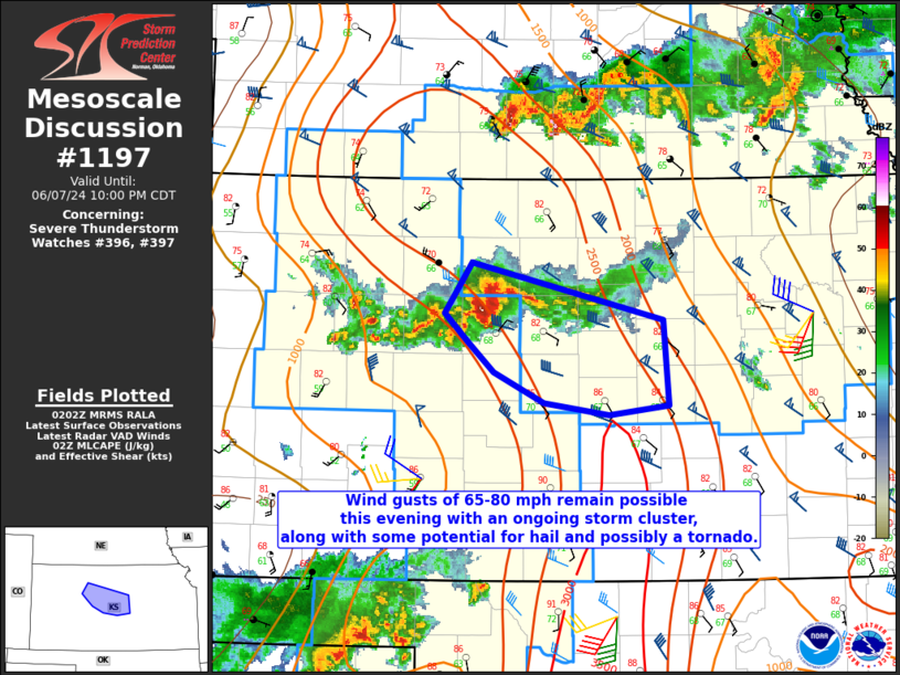
SUMMARY...Wind gusts of 65-80 mph remain possible this evening as a
storm cluster moves east-southeastward, along with some potential
for hail and possibly a tornado.
DISCUSSION...An earlier supercell cluster across northwest KS has
shown some signs of accelerating east-southeastward, with less of a
discrete character compared to earlier this evening. This may
indicate a transition to more of a severe-wind threat, as evidenced
by recent mesonet gusts of 60-80 mph across Trego County, KS.
Despite a tendency for gradually increasing CINH with time tonight,
a strengthening southerly low-level jet (as noted on the KICT VWP)
may help to sustain this cluster as it moves east-southeastward,
with a continued short-term threat for severe gusts potentially in
the 65-80 mph range. In addition, increasing low-level shear/SRH
with time and southeastward extent could support the threat of a
tornado. MLCAPE in excess of 2000 J/kg and strong effective shear
will also continue to support a hail threat with any stronger cells
embedded within the cluster as it approaches parts of central KS.
..Dean.. 06/08/2024
...Please see www.spc.noaa.gov for graphic product...
ATTN...WFO...TOP...ICT...GID...DDC...GLD...
LAT...LON 39389949 38949766 38319761 38239819 38339881 38559928
38779952 39009975 39389949
|
|
Top/All Mesoscale Discussions/Forecast Products/Home
|
|


 @NWSSPC