|
| Mesoscale Discussion 1602 |
|
< Previous MD Next MD >
|
|
Mesoscale Discussion 1602
NWS Storm Prediction Center Norman OK
0757 PM CDT Sat Jul 13 2024
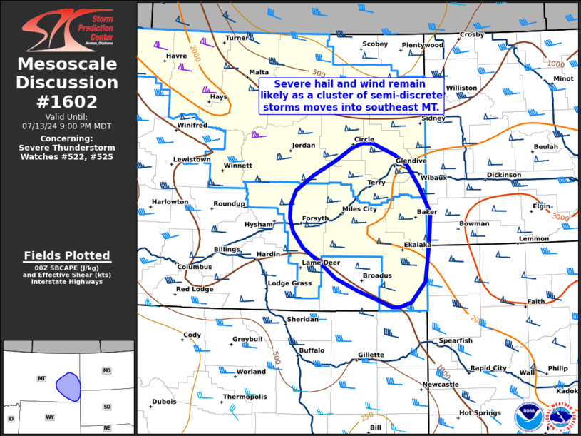
Areas affected...Southeast Montana
Concerning...Severe Thunderstorm Watch 522...525...
Valid 140057Z - 140300Z
The severe weather threat for Severe Thunderstorm Watch 522, 525
continues.
SUMMARY...The threat for severe hail and wind continues as a cluster
of semi-discrete storms moves into southeast Montana. Gradual
upscale growth is still expected later this evening as storms move
towards the Dakotas.
DISCUSSION...Despite numerous storm interactions, the predominant
storm mode has remained supercellular across eastern MT. At least
two supercells continue to exhibit robust mid-level mesocyclones
based on KGGW velocity imagery, suggesting that these storms may
persist for the next hour or two with an attendant large hail
threat. Strong right-mover supercell motion continues to favor a
mean south/southeasterly storm motion, but propagation along a
diffuse buoyancy gradient may result in a more southeasterly motion
with time. Gradual upscale growth is still anticipated later this
evening as this cluster of semi-discrete storms migrates further
into southeastern MT. Early hints of a somewhat more consolidated
cold pool are noted in lowest-tilt velocity imagery between the
cells, suggesting that eventual upscale growth remains probable -
though the exact timing remains uncertain. Recent probabilistic
hazard guidance suggests the wind threat should slowly increase as
the cluster migrates closer to the ND/SD border.
..Moore.. 07/14/2024
...Please see www.spc.noaa.gov for graphic product...
ATTN...WFO...BIS...UNR...BYZ...GGW...
LAT...LON 45280547 45470594 45700627 45910661 46130683 46340689
46520688 46730677 46960641 47180591 47360560 47430538
47420516 47250470 47120445 46800420 46420396 45940400
45420408 45110437 45040462 45050477 45160510 45280547
|
|
Top/All Mesoscale Discussions/Forecast Products/Home
|
|


 @NWSSPC