|
| Mesoscale Discussion 1603 |
|
< Previous MD Next MD >
|
|
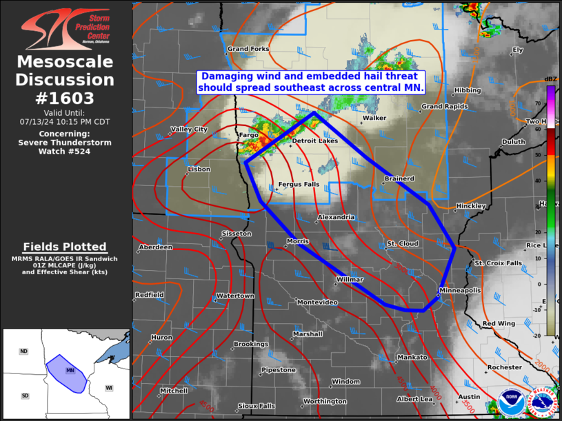
   Mesoscale Discussion 1603
   NWS Storm Prediction Center Norman OK
   0847 PM CDT Sat Jul 13 2024

   Areas affected...northwest to east-central MN

   Concerning...Severe Thunderstorm Watch 524...

   Valid 140147Z - 140315Z

   The severe weather threat for Severe Thunderstorm Watch 524
   continues.

   SUMMARY...A small cluster with an embedded supercell may evolve into
   a small bow and move southeastward across parts of central Minnesota
   tonight. This may yield a confined swath of damaging winds and some
   hail, with an additional severe thunderstorm watch likely.

   DISCUSSION...A trio of updrafts persist over northwest MN in Clay
   and Becker counties, the more prominent of which has been a
   supercell on the western flank. This specific supercell along the
   composite front/outflow appears to be developing a substantial
   enough cold pool for potential acceleration and bowing evolution as
   it likely tracks along the pronounced MLCAPE gradient to its
   southeast. The 00Z MPX sounding in the midst of the gradient sampled
   ample buoyancy and favorable west-northwesterly mid to upper-level
   flow to support an organized strong to severe wind threat tonight.
   While low-level flow will remain modest, the degree of warm theta-e
   advection should be adequate to sustain a small MCS. Latest trends
   suggest this will likely impact areas along the I-94 corridor into
   the overnight.

   ..Grams/Gleason.. 07/14/2024

   ...Please see www.spc.noaa.gov for graphic product...

   ATTN...WFO...DLH...MPX...FGF...

   LAT...LON   47219543 46679448 46089339 45549295 44959327 44799351
               44799384 44869417 45609567 46139636 46599663 47219543
|
|
Top/All Mesoscale Discussions/Forecast Products/Home
|
|


 @NWSSPC