|
| Mesoscale Discussion 1589 |
|
< Previous MD Next MD >
|
|
Mesoscale Discussion 1589
NWS Storm Prediction Center Norman OK
0812 PM CDT Fri Jul 12 2024
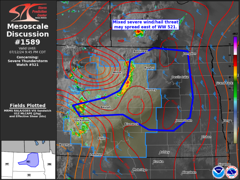
Areas affected...west-central to eastern ND
Concerning...Severe Thunderstorm Watch 521...
Valid 130112Z - 130245Z
The severe weather threat for Severe Thunderstorm Watch 521
continues.
SUMMARY...A mixed severe hail/wind threat may spread east of WW 521
and necessitate a downstream severe thunderstorm watch issuance into
eastern North Dakota.
DISCUSSION...While a late afternoon-early evening supercell has
fully decayed, its lingering outflow continues to progress east
around 30 kts in a portion of north-central ND. Multiple cells
intensified along the north/south-oriented portion of the outflow
into a small linear cluster. These should persist eastward through
the rest of the evening given the large MLCAPE reservoir downstream
as sampled by the 00Z BIS/ABR soundings. While measured gusts have
thus far remained sub-severe, MBX VWP data has sampled rear-inflow
in the 30-40 kt range. It is plausible that further cold pool
strengthening may occur over the next couple hours before nocturnal
MLCIN increases. If this process does occur, the severe wind
potential could increase into a part of eastern ND, east of WW 521.
..Grams/Gleason.. 07/13/2024
...Please see www.spc.noaa.gov for graphic product...
ATTN...WFO...FGF...BIS...
LAT...LON 48640055 48989957 48889815 47599796 47039810 46679878
46719978 47120083 47040257 47340288 47600153 47790099
48170066 48640055
|
|
Top/All Mesoscale Discussions/Forecast Products/Home
|
|


 @NWSSPC