|
| Mesoscale Discussion 1566 |
|
< Previous MD Next MD >
|
|
Mesoscale Discussion 1566
NWS Storm Prediction Center Norman OK
0542 PM CDT Tue Jul 09 2024
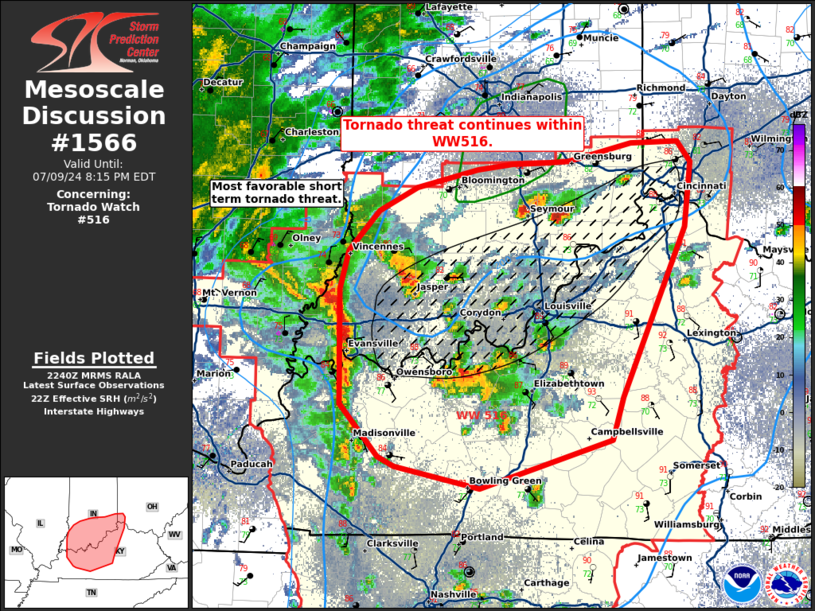
Areas affected...northern Kentucky...southern Indiana...far
southwestern Ohio
Concerning...Tornado Watch 516...
Valid 092242Z - 100015Z
The severe weather threat for Tornado Watch 516 continues.
SUMMARY...Tornado threat continues within WW516.
DISCUSSION...Supercells have been ongoing along and near the warm
front extending across northern Kentucky into southern Indiana. One
ongoing supercell north of Evansville, IN near Johnson, IN has
produced multiple tornadoes across northern Kentucky into southern
Indiana. A more narrow favorable corridor of tornado threat should
be maintained in the next few hours across the Indiana/Kentucky
border along the Ohio River. Within this region, the 850 mb jet will
increase and subsequently contribute to the most favorable region of
effective SRH around 200-300 m2/s2. Any semi-discrete cells that can
track northward/northwestward into this region will likely take
advantage of more favorable low-level SRH, taking on supercell
characteristics and potential for tornadoes as they track near the
warm front. This corridor will shift northeastward through the
evening across southern Indiana and eventually southwestern Ohio
through time.
..Thornton/Gleason.. 07/09/2024
...Please see www.spc.noaa.gov for graphic product...
ATTN...WFO...ILN...LMK...IND...PAH...ILX...
LAT...LON 38418761 38698753 38988725 39158690 39288635 39328602
39338571 39358551 39478493 39498450 39348438 38878444
37648501 37328512 36988633 37138710 37218725 37588760
38418761
|
|
Top/All Mesoscale Discussions/Forecast Products/Home
|
|


 @NWSSPC