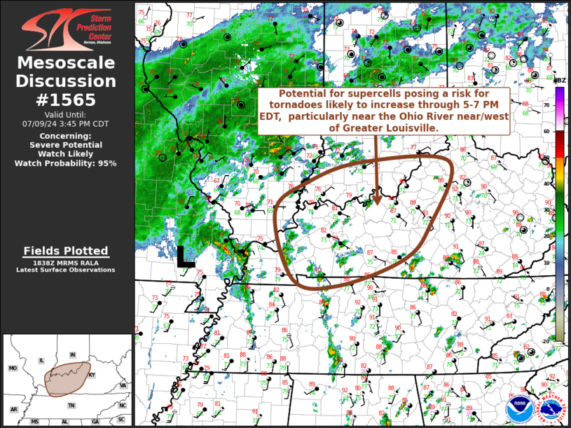
   Mesoscale Discussion 1565
   NWS Storm Prediction Center Norman OK
   0139 PM CDT Tue Jul 09 2024

   Areas affected...western/central Kentucky and adjacent portions of
   southeastern Illinois/southern Indiana

   Concerning...Severe potential...Watch likely

   Valid 091839Z - 092045Z

   Probability of Watch Issuance...95 percent

   SUMMARY...Potential for supercells posing a risk for tornadoes
   appears likely to increase through 5-7 PM EDT, particularly near the
   Ohio River from Evansville/Owensboro through the Greater Louisville
   area.

   DISCUSSION...Beryl's remnant surface low is currently in the process
   of migrating east-northeastward across southeastern Missouri into
   the lower Ohio Valley, with a zone of strengthening differential
   surface heating becoming better defined near the Ohio River
   downstream toward the Greater Cincinnati area.  South of this zone,
   boundary-layer destabilization is ongoing, supported by both
   insolation and slowly increasing moisture.  The increasingly buoyant
   low-level environment is supporting the development of showers and
   isolated to widely scattered weak thunderstorms, but this is
   occurring beneath a notably warm and warming mid-level environment,
   which will tend to slow, if not suppress, intensifying convective
   development.

   Into the 21-23Z time frame, in the peaking boundary-layer
   instability, latest Rapid Refresh suggests that a relatively minimum
   in mid-level inhibition may linger near the Ohio River, roughly from
   Evansville IN/Owensboro Ky through the Greater Louisville area, near
   the nose of the stronger southerly flow around 850 mb associated
   with Beryl.  Although this jet streak is forecast to weak some,
   speeds on the order of 30+ kt appear likely to still contribute to
   sizable clockwise-curved low-level hodographs, particularly along
   or just south of the differential heating zone.

   Given dynamic forcing associated with occasionally strengthening
   low-level mesocyclones, and the near-surface buoyancy associated
   with the high boundary-layer dew points (increasing to 75+ F),
   low-level upward accelerations may become increasingly conducive to
   tornadic potential in evolving supercell structures.

   ..Kerr/Guyer.. 07/09/2024

   ...Please see www.spc.noaa.gov for graphic product...

   ATTN...WFO...ILN...LMK...OHX...IND...PAH...

   LAT...LON   37748853 38258783 38588668 38588480 37518524 36938580
               36488720 36598814 37748853
|


 @NWSSPC