|
| Mesoscale Discussion 1525 |
|
< Previous MD Next MD >
|
|
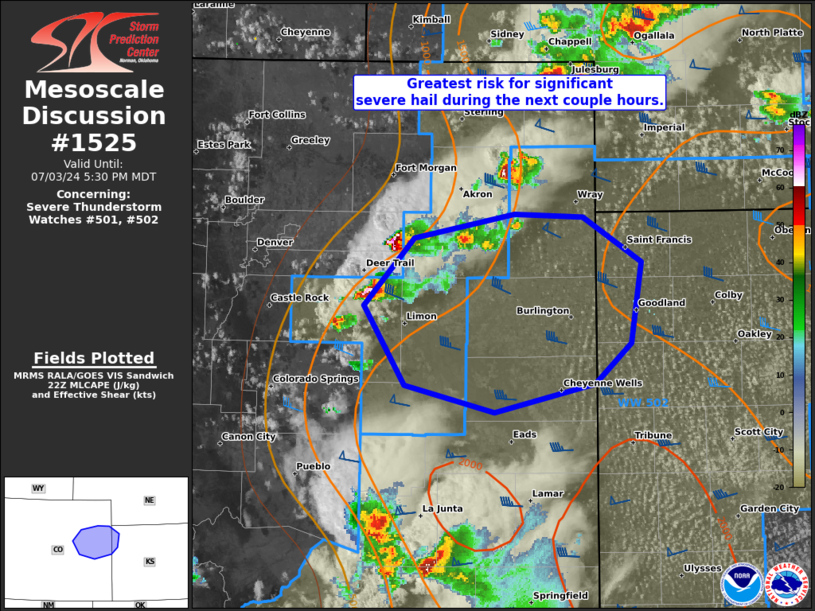
   Mesoscale Discussion 1525
   NWS Storm Prediction Center Norman OK
   0528 PM CDT Wed Jul 03 2024

   Areas affected...east-central CO into far northwest KS

   Concerning...Severe Thunderstorm Watch 501...502...

   Valid 032228Z - 032330Z

   The severe weather threat for Severe Thunderstorm Watch 501, 502
   continues.

   SUMMARY...The greatest risk for significant severe hail between
   2-2.5 inches is anticipated through about 7 PM MDT over east-central
   Colorado near the I-70 corridor. An increase in severe wind
   potential is expected towards the northwest Kansas border.

   DISCUSSION...A pair of slow-moving supercells between Denver and
   Limon will have the greatest potential to produce large hail beyond
   2 inches over the next 2-3 hours. These storms will move towards the
   peak buoyancy plume characterized by MLCAPE of 1500-2000 J/kg along
   the CO/KS border area. With favorable westerly speed shear above 2
   km AGL per the FTG/PUX VWP data, in conjunction with a modest
   increase in low-level south-southeasterly flow in the next few
   hours, intensification of these supercells is plausible. This will
   also include a risk for increasing severe wind gusts, as
   persistently indicated by recent WoFS guidance.

   ..Grams.. 07/03/2024

   ...Please see www.spc.noaa.gov for graphic product...

   ATTN...WFO...GLD...BOU...

   LAT...LON   39830361 39980274 39970215 39660166 39120175 38850206
               38660292 38850368 39380403 39830361
|
|
Top/All Mesoscale Discussions/Forecast Products/Home
|
|


 @NWSSPC