|
| Mesoscale Discussion 1285 |
|
< Previous MD Next MD >
|
|
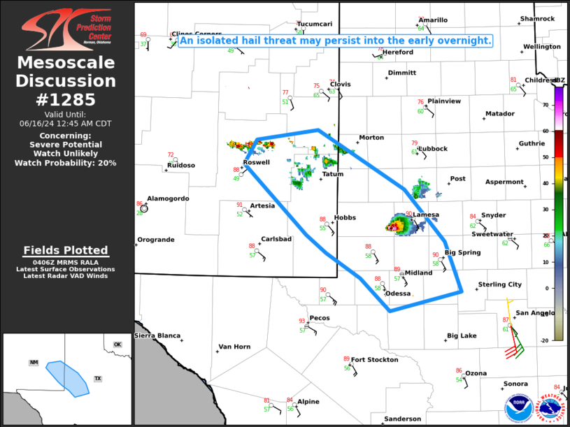
   Mesoscale Discussion 1285
   NWS Storm Prediction Center Norman OK
   1109 PM CDT Sat Jun 15 2024

   Areas affected...TX Permian Basin into far southeast NM

   Concerning...Severe potential...Watch unlikely

   Valid 160409Z - 160545Z

   Probability of Watch Issuance...20 percent

   SUMMARY...An isolated hail threat could persist into the early
   overnight hours.

   DISCUSSION...An isolated supercell is moving southeastward toward
   Midland late this evening. While MLCINH is increasing and the
   longevity of this cell is uncertain, steep midlevel lapse rates and
   favorable deep-layer shear (as noted on the 00Z MAF sounding) will
   continue to support a large hail threat for as long as this storm
   persists, along with some potential for localized severe gusts.

   Farther west, elevated convection is gradually increasing across
   southeast NM, along the western periphery of deeper low-level
   moisture. This convection is possibly being aided by a subtle
   southern-stream vorticity maximum, and some recent CAM guidance
   suggests that a strong storm or two could emerge out of this
   developing area of convection, and move eastward with an isolated
   hail threat into the early overnight hours.

   ..Dean/Smith.. 06/16/2024

   ...Please see www.spc.noaa.gov for graphic product...

   ATTN...WFO...SJT...LUB...MAF...ABQ...

   LAT...LON   33440448 33740428 33880336 33110204 32440144 31810121
               31570228 31990272 32310322 32530352 33440448
|
|
Top/All Mesoscale Discussions/Forecast Products/Home
|
|


 @NWSSPC