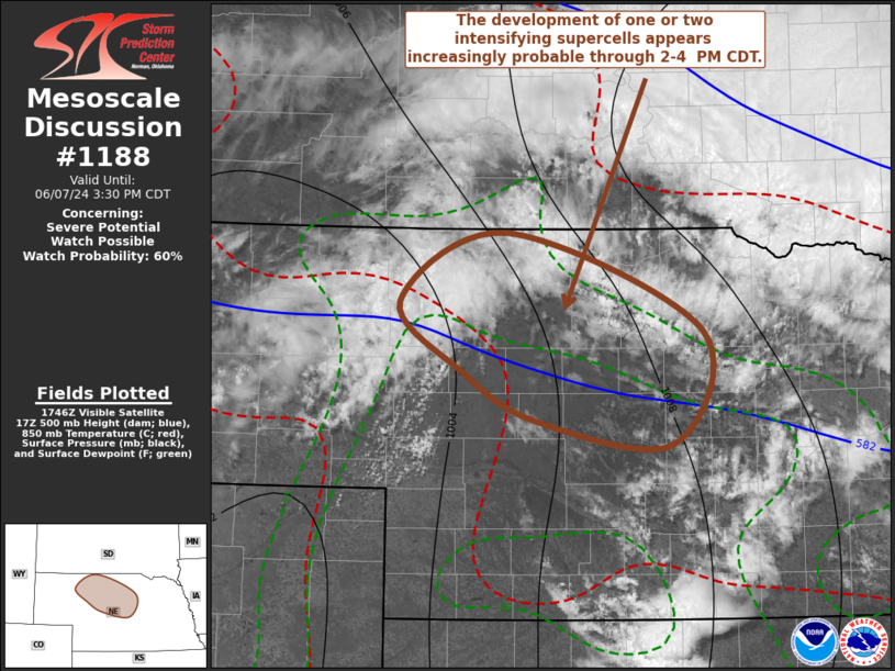
   Mesoscale Discussion 1188
   NWS Storm Prediction Center Norman OK
   1254 PM CDT Fri Jun 07 2024

   Areas affected...north central into central Nebraska

   Concerning...Severe potential...Watch possible

   Valid 071754Z - 072030Z

   Probability of Watch Issuance...60 percent

   SUMMARY...Rapid thunderstorm development, including or two
   intensifying supercells, appears increasingly probable through 2-4
   PM CDT.  This activity will pose a risk for producing large hail in
   excess of 2 inches in diameter, locally strong surface gusts and
   perhaps a tornado or two.

   DISCUSSION...Within deepening lee surface troughing, continuing
   insolation and northward advection of low-level moisture on
   southerly low-level flow are contribute to rapid boundary-layer
   destabilization and weakening inhibition across the Nebraska
   Sandhills vicinity.  This is occurring beneath broadly anticyclonic,
   but moderate to strong flow near the northeastern periphery of
   large-scale mid/upper ridging.  However, forcing for ascent
   associated with weak perturbations progressing through this regime
   is in the process of spreading eastward across the Nebraska
   Panhandle.  This lift is likely providing support for the ongoing
   high-based convective development approaching the Sandhills.

   As surface dew points continue to rise into and through the lower
   60s, and temperatures warm into the mid 80s, forecast soundings
   suggest that convective temperatures will be approached.  It appears
   that this will coincide with strengthening deep-layer lift, aided by
   lower/mid-tropospheric warm advection initially becoming focused to
   northwest and west of the Thedford/Ainsworth vicinities by 19-21Z.

   One or two rapidly developing and intensifying supercells appears
   possible, in the presence of thermodynamic profiles characterized by
   steep mid-level lapse rates with CAPE increasing in excess of 2000
   J/kg and strongly sheared deep-layer westerly mean flow increasing
   to around 30 kt.  As the stronger storms mature, they will tend to
   propagate southeastward accompanied by increasing risk for large
   hail, and at  least some potential for producing a tornado or two.

   ..Kerr/Guyer.. 06/07/2024

   ...Please see www.spc.noaa.gov for graphic product...

   ATTN...WFO...GID...LBF...

   LAT...LON   42440193 42970083 42229881 41339913 41520055 41890128
               42440193
|


 @NWSSPC