|
| Mesoscale Discussion 1186 |
|
< Previous MD Next MD >
|
|
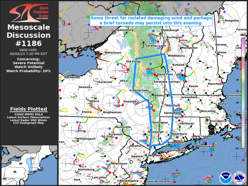
   Mesoscale Discussion 1186
   NWS Storm Prediction Center Norman OK
   0501 PM CDT Thu Jun 06 2024

   Areas affected...Parts of eastern NY into western CT/MA and
   southwest VT

   Concerning...Severe potential...Watch unlikely

   Valid 062201Z - 062330Z

   Probability of Watch Issuance...20 percent

   SUMMARY...Some threat for isolated damaging wind and perhaps a brief
   tornado could spread eastward into this evening.

   DISCUSSION...A band of convection is currently moving across eastern
   NY, with a rather prominent mesolow noted northwest of Albany. The
   immediate downstream environment remains rather moist and modestly
   unstable (MLCAPE in the 500-1000 J/kg range), with sufficient
   deep-layer shear to support some storm organization. Generally weak
   low/midlevel lapse rates have generally limited the severe threat
   thus far. However, surface winds remain backed along/east of a
   surface trough/weak front, and 0-1 km SRH of 100-150 m2/s2 is noted
   both from objective mesoanalyses and the VWP from KENX.

   Given the relatively moist boundary layer and somewhat favorable
   low-level shear, a brief tornado cannot be ruled out with any
   persistent circulation embedded within the larger storm cluster.
   Otherwise, isolated damaging winds remain possible, both with any
   stronger bowing segment that can be maintained, and also in the
   vicinity of the mesolow where rather strong velocities are noted
   from KENX.

   ..Dean/Guyer.. 06/06/2024

   ...Please see www.spc.noaa.gov for graphic product...

   ATTN...WFO...BOX...BTV...OKX...ALY...

   LAT...LON   41037391 41567382 42507396 42827450 42927463 43857450
               44027328 43557314 42267292 41387301 41177336 41127383
               41037391
|
|
Top/All Mesoscale Discussions/Forecast Products/Home
|
|


 @NWSSPC