|
| Mesoscale Discussion 925 |
|
< Previous MD Next MD >
|
|
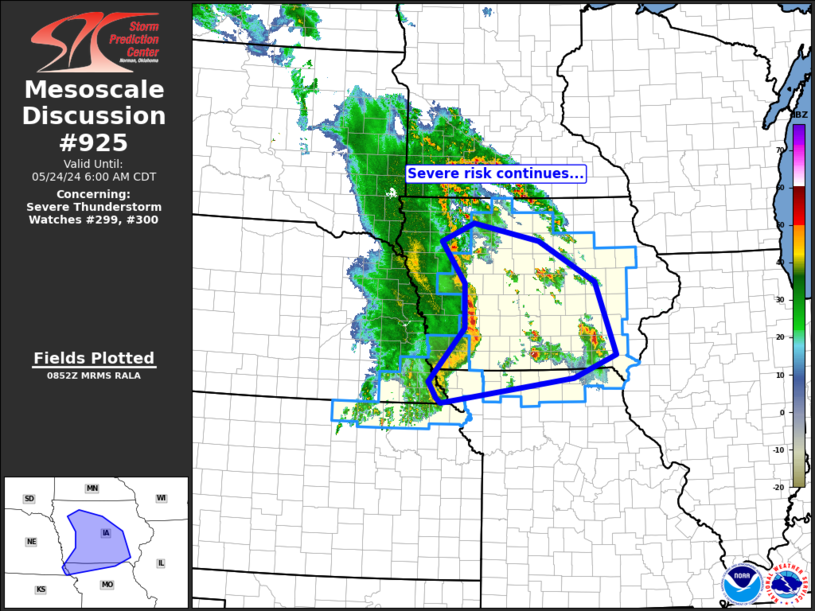
   Mesoscale Discussion 0925
   NWS Storm Prediction Center Norman OK
   0354 AM CDT Fri May 24 2024

   Areas affected...Iowa/northern Missouri and vicinity

   Concerning...Severe Thunderstorm Watch 299...300...

   Valid 240854Z - 241100Z

   The severe weather threat for Severe Thunderstorm Watch 299, 300
   continues.

   SUMMARY...Risk for damaging winds and a couple of brief tornadoes
   continues across western and into central Iowa, and vicinity.

   DISCUSSION...A well-organized line of storms with embedded LEWPs and
   occasional misocyclones continues moving eastward at around 40 kt --
   though at near 50 kt within the surging portion of the line crossing
   west-central Iowa at this time.  Several gusts to near/in excess of
   severe levels have been received over the past hour or so, and
   expect risk to continue eastward as the line moves through an amply
   unstable environment into central parts of Iowa.

   Separately, more isolated/cellular storms continue to increase in
   coverage across Iowa ahead of the main convective line, in a zone of
   warm advection.  This convection is elevated atop a rather deep
   (1.5km) but weakly stable surface-based layer, suggesting that
   primary severe potential should remain large hail with this
   activity, until the main line of storms and associated cold pool
   arrives from the west.  One exception may be with a cluster of cells
   moving quickly northeastward across Keokuk and Jefferson Counties in
   southeastern Iowa, which seems to be evolving into a more
   organized/bowing cluster (suggesting potential for strong gusts that
   may reach the surface).

   ..Goss.. 05/24/2024

   ...Please see www.spc.noaa.gov for graphic product...

   ATTN...WFO...DVN...DMX...EAX...FSD...OAX...

   LAT...LON   40099565 40379582 41299502 42049504 42769557 43079484
               42779335 42079209 40839163 40439257 40019554 40099565
|
|
Top/All Mesoscale Discussions/Forecast Products/Home
|
|


 @NWSSPC