|
| Mesoscale Discussion 1403 |
|
< Previous MD Next MD >
|
|
Mesoscale Discussion 1403
NWS Storm Prediction Center Norman OK
0930 PM CDT Tue Aug 04 2020
Areas affected...Southeastern Colorado into Oklahoma and Texas
Panhandles
Concerning...Severe Thunderstorm Watch 418...
Valid 050230Z - 050300Z
The severe weather threat for Severe Thunderstorm Watch 418
continues.
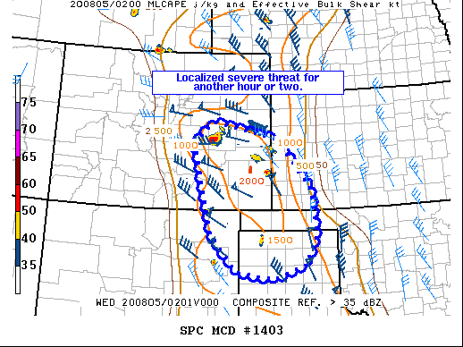
SUMMARY...Severe threat becoming more localized and may persist for
another hour or two with remaining organized storms. Majority of WW
418 will be allowed to expire as scheduled.
DISCUSSION...A couple of organized storms remain within WW 418. The
strongest storm is now moving into Crowley County, CO which has
recently had measured 2.5 inch hail reported. Overall, with
increasing inhibition and lack of organized cold pool development,
the severe threat is becoming more localized. A strong/severe storm
may be able to linger for another hour or two. Other than the
possibility of local extensions to the watch, the remainder of the
WW will be allowed to expire as scheduled.
..Wendt.. 08/05/2020
...Please see www.spc.noaa.gov for graphic product...
ATTN...WFO...DDC...GLD...AMA...PUB...BOU...ABQ...
LAT...LON 38700449 39230388 38800190 37590080 36350062 35640097
35300197 35470311 36380393 38700449
|
|
Top/All Mesoscale Discussions/Forecast Products/Home
|
|


 @NWSSPC