 Note:
The expiration time in the watch graphic is amended if the watch is
replaced, cancelled or extended.
Note:
Note:
The expiration time in the watch graphic is amended if the watch is
replaced, cancelled or extended.
Note: Click for
Watch Status Reports.
SEL4
URGENT - IMMEDIATE BROADCAST REQUESTED
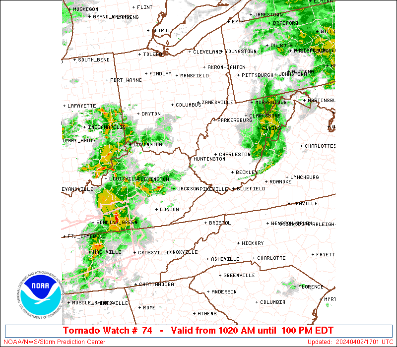
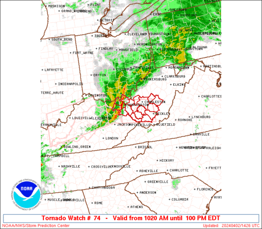
Tornado Watch Number 74
NWS Storm Prediction Center Norman OK
1020 AM EDT Tue Apr 2 2024
The NWS Storm Prediction Center has issued a
* Tornado Watch for portions of
Extreme northeast Kentucky
Extreme southern Ohio
Southern West Virginia
* Effective this Tuesday morning and afternoon from 1020 AM until
100 PM EDT.
* Primary threats include...
A couple tornadoes possible
Scattered damaging wind gusts to 70 mph likely
Isolated large hail events to 1 inch in diameter possible
SUMMARY...A well-developed squall line may persist for a few more
hours as it moves from Kentucky into West Virginia this morning.
Damaging gusts of 60-70 mph and a couple of tornadoes with embedded
circulations will be possible.
The tornado watch area is approximately along and 35 statute miles
north and south of a line from 25 miles southwest of Huntington WV
to 10 miles north northeast of Beckley WV. For a complete depiction
of the watch see the associated watch outline update (WOUS64 KWNS
WOU4).
PRECAUTIONARY/PREPAREDNESS ACTIONS...
REMEMBER...A Tornado Watch means conditions are favorable for
tornadoes and severe thunderstorms in and close to the watch
area. Persons in these areas should be on the lookout for
threatening weather conditions and listen for later statements
and possible warnings.
&&
OTHER WATCH INFORMATION...CONTINUE...WW 73...
AVIATION...Tornadoes and a few severe thunderstorms with hail
surface and aloft to 1 inch. Extreme turbulence and surface wind
gusts to 60 knots. A few cumulonimbi with maximum tops to 450. Mean
storm motion vector 28050.
...Thompson
 Note:
The Aviation Watch (SAW) product is an approximation to the watch area.
The actual watch is depicted by the shaded areas.
Note:
The Aviation Watch (SAW) product is an approximation to the watch area.
The actual watch is depicted by the shaded areas.
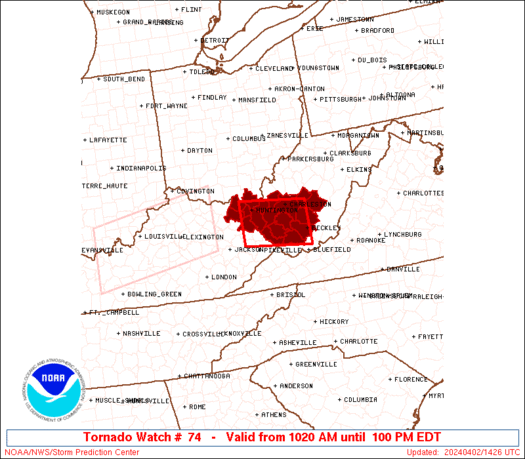
SAW4
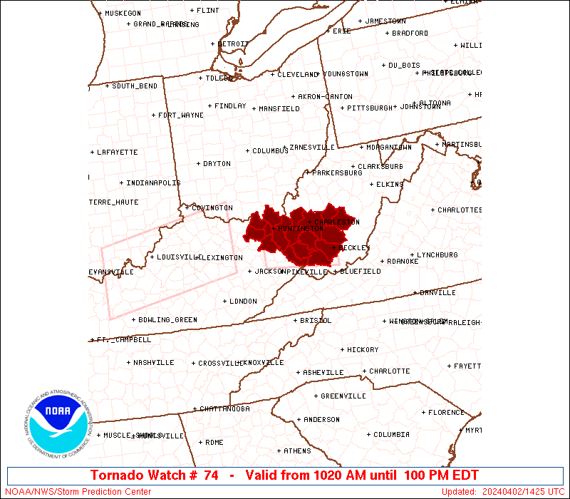
WW 74 TORNADO KY OH WV 021420Z - 021700Z
AXIS..35 STATUTE MILES NORTH AND SOUTH OF LINE..
25SW HTS/HUNTINGTON WV/ - 10NNE BKW/BECKLEY WV/
..AVIATION COORDS.. 30NM N/S /56SW HNN - 9NNE BKW/
HAIL SURFACE AND ALOFT..1 INCH. WIND GUSTS..60 KNOTS.
MAX TOPS TO 450. MEAN STORM MOTION VECTOR 28050.
LAT...LON 38618288 38418105 37418105 37598288
THIS IS AN APPROXIMATION TO THE WATCH AREA. FOR A
COMPLETE DEPICTION OF THE WATCH SEE WOUS64 KWNS
FOR WOU4.
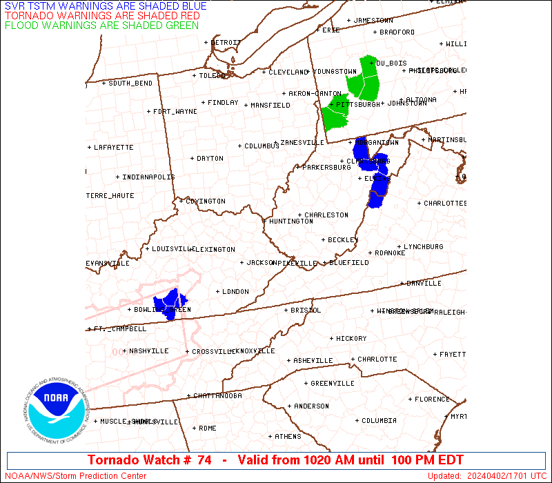
Watch 74 Status Report Messages:
STATUS REPORT #2 ON WW 74
VALID 021630Z - 021700Z
SEVERE WEATHER THREAT CONTINUES RIGHT OF A LINE FROM 45 WNW BLF
TO 20 ESE BKW TO 15 NNE SSU TO 30 SW EKN TO 20 S MGW.
WW 74 WILL BE ALLOWED TO EXPIRE AT 021700Z.
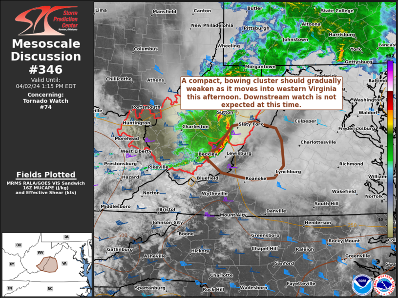
FOR ADDITIONAL INFORMATION SEE MESOSCALE DISCUSSION 346
..GLEASON..04/02/24
ATTN...WFO...RLX...
&&
STATUS REPORT FOR WT 74
SEVERE WEATHER THREAT CONTINUES FOR THE FOLLOWING AREAS
WVC075-081-083-097-101-109-021700-
WV
. WEST VIRGINIA COUNTIES INCLUDED ARE
POCAHONTAS RALEIGH RANDOLPH
UPSHUR WEBSTER WYOMING
$$
THE WATCH STATUS MESSAGE IS FOR GUIDANCE PURPOSES ONLY. PLEASE
REFER TO WATCH COUNTY NOTIFICATION STATEMENTS FOR OFFICIAL
INFORMATION ON COUNTIES...INDEPENDENT CITIES AND MARINE ZONES
CLEARED FROM SEVERE THUNDERSTORM AND TORNADO WATCHES.
$$
STATUS REPORT #1 ON WW 74
VALID 021520Z - 021640Z
SEVERE WEATHER THREAT CONTINUES RIGHT OF A LINE FROM 25 E JKL TO
35 SE HTS TO 15 SSW CRW TO 5 NNW CRW TO 20 SSW PKB.
FOR ADDITIONAL INFORMATION SEE MESOSCALE DISCUSSION 344
..GLEASON..04/02/24
ATTN...WFO...RLX...
&&
STATUS REPORT FOR WT 74
SEVERE WEATHER THREAT CONTINUES FOR THE FOLLOWING AREAS
WVC005-007-013-015-019-021-035-039-041-045-059-067-075-081-083-
087-097-101-109-021640-
WV
. WEST VIRGINIA COUNTIES INCLUDED ARE
BOONE BRAXTON CALHOUN
CLAY FAYETTE GILMER
JACKSON KANAWHA LEWIS
LOGAN MINGO NICHOLAS
POCAHONTAS RALEIGH RANDOLPH
ROANE UPSHUR WEBSTER
WYOMING
$$
THE WATCH STATUS MESSAGE IS FOR GUIDANCE PURPOSES ONLY. PLEASE
REFER TO WATCH COUNTY NOTIFICATION STATEMENTS FOR OFFICIAL
INFORMATION ON COUNTIES...INDEPENDENT CITIES AND MARINE ZONES
CLEARED FROM SEVERE THUNDERSTORM AND TORNADO WATCHES.
$$
Note:
Click for Complete Product Text.
Tornadoes
Probability of 2 or more tornadoes
|
Mod (40%)
|
Probability of 1 or more strong (EF2-EF5) tornadoes
|
Low (20%)
|
Wind
Probability of 10 or more severe wind events
|
Mod (60%)
|
Probability of 1 or more wind events > 65 knots
|
Low (20%)
|
Hail
Probability of 10 or more severe hail events
|
Low (20%)
|
Probability of 1 or more hailstones > 2 inches
|
Low (10%)
|
Combined Severe Hail/Wind
Probability of 6 or more combined severe hail/wind events
|
High (80%)
|
For each watch, probabilities for particular events inside the watch
(listed above in each table) are determined by the issuing forecaster.
The "Low" category contains probability values ranging from less than 2%
to 20% (EF2-EF5 tornadoes), less than 5% to 20% (all other probabilities),
"Moderate" from 30% to 60%, and "High" from 70% to greater than 95%.
High values are bolded and lighter in color to provide awareness of
an increased threat for a particular event.


 @NWSSPC