 Note:
The expiration time in the watch graphic is amended if the watch is
replaced, cancelled or extended.
Note:
Note:
The expiration time in the watch graphic is amended if the watch is
replaced, cancelled or extended.
Note: Click for
Watch Status Reports.
SEL3
URGENT - IMMEDIATE BROADCAST REQUESTED
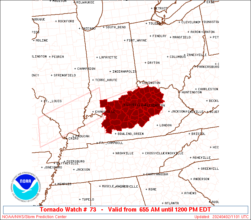
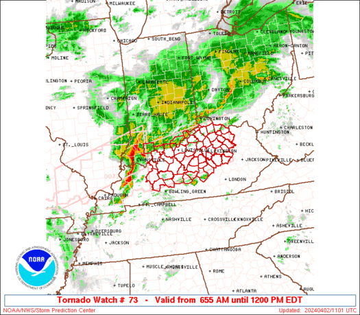
Tornado Watch Number 73
NWS Storm Prediction Center Norman OK
655 AM EDT Tue Apr 2 2024
The NWS Storm Prediction Center has issued a
* Tornado Watch for portions of
Southern Indiana
Central and Northern Kentucky
* Effective this Tuesday morning from 655 AM until NOON EDT.
* Primary threats include...
A few tornadoes possible
Scattered damaging winds likely with isolated significant gusts
to 75 mph possible
Isolated large hail events to 1.5 inches in diameter possible
SUMMARY...A severe squall line will continue to move east across
portions of the Ohio Valley this morning. A few tornadoes are
possible with the stronger storm-scale circulations embedded within
the line, in addition to the risk for scattered severe gusts.
The tornado watch area is approximately along and 50 statute miles
north and south of a line from 75 miles west southwest of Louisville
KY to 55 miles east northeast of Lexington KY. For a complete
depiction of the watch see the associated watch outline update
(WOUS64 KWNS WOU3).
PRECAUTIONARY/PREPAREDNESS ACTIONS...
REMEMBER...A Tornado Watch means conditions are favorable for
tornadoes and severe thunderstorms in and close to the watch
area. Persons in these areas should be on the lookout for
threatening weather conditions and listen for later statements
and possible warnings.
&&
OTHER WATCH INFORMATION...CONTINUE...WW 72...
AVIATION...Tornadoes and a few severe thunderstorms with hail
surface and aloft to 1.5 inches. Extreme turbulence and surface wind
gusts to 65 knots. A few cumulonimbi with maximum tops to 450. Mean
storm motion vector 26050.
...Smith

   SEL3

   URGENT - IMMEDIATE BROADCAST REQUESTED
   Tornado Watch Number 73
   NWS Storm Prediction Center Norman OK
   655 AM EDT Tue Apr 2 2024

   The NWS Storm Prediction Center has issued a

   * Tornado Watch for portions of
     Southern Indiana
     Central and Northern Kentucky

   * Effective this Tuesday morning from 655 AM until NOON EDT.

   * Primary threats include...
     A few tornadoes possible
     Scattered damaging winds likely with isolated significant gusts
       to 75 mph possible
     Isolated large hail events to 1.5 inches in diameter possible

   SUMMARY...A severe squall line will continue to move east across
   portions of the Ohio Valley this morning.  A few tornadoes are
   possible with the stronger storm-scale circulations embedded within
   the line, in addition to the risk for scattered severe gusts.

   The tornado watch area is approximately along and 50 statute miles
   north and south of a line from 75 miles west southwest of Louisville
   KY to 55 miles east northeast of Lexington KY. For a complete
   depiction of the watch see the associated watch outline update
   (WOUS64 KWNS WOU3).

   PRECAUTIONARY/PREPAREDNESS ACTIONS...

   REMEMBER...A Tornado Watch means conditions are favorable for
   tornadoes and severe thunderstorms in and close to the watch
   area. Persons in these areas should be on the lookout for
   threatening weather conditions and listen for later statements
   and possible warnings.

   &&

   OTHER WATCH INFORMATION...CONTINUE...WW 72...

   AVIATION...Tornadoes and a few severe thunderstorms with hail
   surface and aloft to 1.5 inches. Extreme turbulence and surface wind
   gusts to 65 knots. A few cumulonimbi with maximum tops to 450. Mean
   storm motion vector 26050.

   ...Smith
 Note:
The Aviation Watch (SAW) product is an approximation to the watch area.
The actual watch is depicted by the shaded areas.
Note:
The Aviation Watch (SAW) product is an approximation to the watch area.
The actual watch is depicted by the shaded areas.
   SAW3
   WW 73 TORNADO IN KY 021055Z - 021600Z
   AXIS..50 STATUTE MILES NORTH AND SOUTH OF LINE..
   75WSW SDF/LOUISVILLE KY/ - 55ENE LEX/LEXINGTON KY/
   ..AVIATION COORDS.. 45NM N/S /38ESE PXV - 64SE CVG/
   HAIL SURFACE AND ALOFT..1.5 INCHES. WIND GUSTS..65 KNOTS.
   MAX TOPS TO 450. MEAN STORM MOTION VECTOR 26050.

   LAT...LON 38488700 39058366 37618366 37038700

   THIS IS AN APPROXIMATION TO THE WATCH AREA.  FOR A
   COMPLETE DEPICTION OF THE WATCH SEE WOUS64 KWNS
   FOR WOU3.
Watch 73 Status Report Messages:
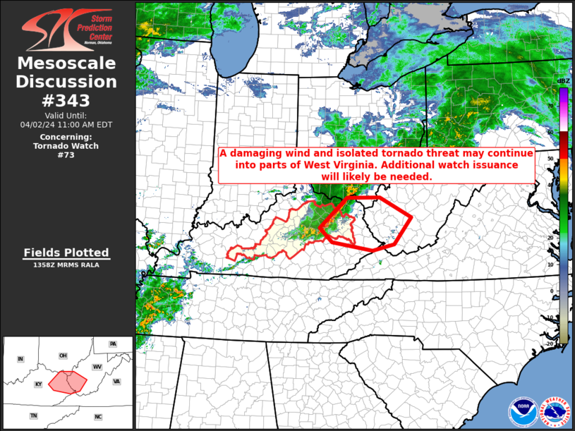
STATUS REPORT #4 ON WW 73

VALID 021405Z - 021540Z

SEVERE WEATHER THREAT CONTINUES RIGHT OF A LINE FROM 60 WNW LOZ
TO 20 S LEX TO 35 NW JKL TO 55 N JKL.

FOR ADDITIONAL INFORMATION SEE MESOSCALE DISCUSSION 343

..GLEASON..04/02/24

ATTN...WFO...LMK...JKL...ILN...

&&

STATUS REPORT FOR WT 73

SEVERE WEATHER THREAT CONTINUES FOR THE FOLLOWING AREAS

KYC045-063-065-079-137-151-153-165-175-197-205-237-021540-

KY
.    KENTUCKY COUNTIES INCLUDED ARE

CASEY		     ELLIOTT		 ESTILL
GARRARD 	     LINCOLN		 MADISON
MAGOFFIN	     MENIFEE		 MORGAN
POWELL		     ROWAN		 WOLFE
$$


THE WATCH STATUS MESSAGE IS FOR GUIDANCE PURPOSES ONLY.  PLEASE
REFER TO WATCH COUNTY NOTIFICATION STATEMENTS FOR OFFICIAL
INFORMATION ON COUNTIES...INDEPENDENT CITIES AND MARINE ZONES
CLEARED FROM SEVERE THUNDERSTORM AND TORNADO WATCHES.
$$

STATUS REPORT #3 ON WW 73

VALID 021340Z - 021440Z

SEVERE WEATHER THREAT CONTINUES RIGHT OF A LINE FROM 10 N BWG TO
25 NNE BWG TO 15 WSW LEX TO 15 E LEX TO 55 ESE LUK.

..GLEASON..04/02/24

ATTN...WFO...LMK...JKL...ILN...

&&

STATUS REPORT FOR WT 73

SEVERE WEATHER THREAT CONTINUES FOR THE FOLLOWING AREAS

KYC011-017-021-045-049-061-065-067-069-079-087-099-113-123-137-
151-155-161-167-173-181-197-217-229-021440-

KY
.    KENTUCKY COUNTIES INCLUDED ARE

BATH		     BOURBON		 BOYLE
CASEY		     CLARK		 EDMONSON
ESTILL		     FAYETTE		 FLEMING
GARRARD 	     GREEN		 HART
JESSAMINE	     LARUE		 LINCOLN
MADISON 	     MARION		 MASON
MERCER		     MONTGOMERY 	 NICHOLAS
POWELL		     TAYLOR		 WASHINGTON
$$


THE WATCH STATUS MESSAGE IS FOR GUIDANCE PURPOSES ONLY.  PLEASE
REFER TO WATCH COUNTY NOTIFICATION STATEMENTS FOR OFFICIAL
INFORMATION ON COUNTIES...INDEPENDENT CITIES AND MARINE ZONES
CLEARED FROM SEVERE THUNDERSTORM AND TORNADO WATCHES.
$$

STATUS REPORT #2 ON WW 73

VALID 021250Z - 021340Z

SEVERE WEATHER THREAT CONTINUES RIGHT OF A LINE FROM 25 W BWG TO
40 NNE BWG TO 20 SW SDF TO 25 NW LEX TO 55 ESE LUK.

..LEITMAN..04/02/24

ATTN...WFO...LMK...JKL...ILN...

&&

STATUS REPORT FOR WT 73

SEVERE WEATHER THREAT CONTINUES FOR THE FOLLOWING AREAS

KYC005-011-017-021-029-045-049-061-065-067-069-073-079-087-093-
097-099-113-123-137-151-155-161-167-173-179-181-197-201-209-215-
217-229-239-021340-

KY
.    KENTUCKY COUNTIES INCLUDED ARE

ANDERSON	     BATH		 BOURBON
BOYLE		     BULLITT		 CASEY
CLARK		     EDMONSON		 ESTILL
FAYETTE 	     FLEMING		 FRANKLIN
GARRARD 	     GREEN		 HARDIN
HARRISON	     HART		 JESSAMINE
LARUE		     LINCOLN		 MADISON
MARION		     MASON		 MERCER
MONTGOMERY	     NELSON		 NICHOLAS
POWELL		     ROBERTSON		 SCOTT
SPENCER 	     TAYLOR		 WASHINGTON
WOODFORD
$$


THE WATCH STATUS MESSAGE IS FOR GUIDANCE PURPOSES ONLY.  PLEASE
REFER TO WATCH COUNTY NOTIFICATION STATEMENTS FOR OFFICIAL
INFORMATION ON COUNTIES...INDEPENDENT CITIES AND MARINE ZONES
CLEARED FROM SEVERE THUNDERSTORM AND TORNADO WATCHES.
$$

STATUS REPORT #1 ON WW 73

VALID 021230Z - 021340Z

SEVERE WEATHER THREAT CONTINUES RIGHT OF A LINE FROM 35 S OWB TO
35 N BWG TO 35 WSW SDF TO 20 NE SDF TO 30 N LEX TO 50 ESE LUK.

FOR ADDITIONAL INFORMATION SEE MESOSCALE DISCUSSION 341.

..LEITMAN..04/02/24

ATTN...WFO...LMK...JKL...ILN...

&&

STATUS REPORT FOR WT 73

SEVERE WEATHER THREAT CONTINUES FOR THE FOLLOWING AREAS

KYC005-011-017-021-029-031-045-049-061-065-067-069-073-079-085-
087-093-097-099-103-111-113-123-137-151-155-161-163-167-173-179-
181-185-197-201-209-211-215-217-229-239-021340-

KY
.    KENTUCKY COUNTIES INCLUDED ARE

ANDERSON	     BATH		 BOURBON
BOYLE		     BULLITT		 BUTLER
CASEY		     CLARK		 EDMONSON
ESTILL		     FAYETTE		 FLEMING
FRANKLIN	     GARRARD		 GRAYSON
GREEN		     HARDIN		 HARRISON
HART		     HENRY		 JEFFERSON
JESSAMINE	     LARUE		 LINCOLN
MADISON 	     MARION		 MASON
MEADE		     MERCER		 MONTGOMERY
NELSON		     NICHOLAS		 OLDHAM
POWELL		     ROBERTSON		 SCOTT
SHELBY		     SPENCER		 TAYLOR
WASHINGTON	     WOODFORD
$$


THE WATCH STATUS MESSAGE IS FOR GUIDANCE PURPOSES ONLY.  PLEASE
REFER TO WATCH COUNTY NOTIFICATION STATEMENTS FOR OFFICIAL
INFORMATION ON COUNTIES...INDEPENDENT CITIES AND MARINE ZONES
CLEARED FROM SEVERE THUNDERSTORM AND TORNADO WATCHES.
$$
Note:
Click for Complete Product Text.
Tornadoes
Probability of 2 or more tornadoes
|
Mod (50%)
|
Probability of 1 or more strong (EF2-EF5) tornadoes
|
Low (20%)
|
Wind
Probability of 10 or more severe wind events
|
Mod (60%)
|
Probability of 1 or more wind events > 65 knots
|
Mod (40%)
|
Hail
Probability of 10 or more severe hail events
|
Mod (30%)
|
Probability of 1 or more hailstones > 2 inches
|
Low (10%)
|
Combined Severe Hail/Wind
Probability of 6 or more combined severe hail/wind events
|
High (80%)
|
For each watch, probabilities for particular events inside the watch
(listed above in each table) are determined by the issuing forecaster.
The "Low" category contains probability values ranging from less than 2%
to 20% (EF2-EF5 tornadoes), less than 5% to 20% (all other probabilities),
"Moderate" from 30% to 60%, and "High" from 70% to greater than 95%.
High values are bolded and lighter in color to provide awareness of
an increased threat for a particular event.


 @NWSSPC