Note:
The expiration time in the watch graphic is amended if the watch is
replaced, cancelled or extended.
Note:
Note:
The expiration time in the watch graphic is amended if the watch is
replaced, cancelled or extended.
Note: Click for
Watch Status Reports.
SEL3
URGENT - IMMEDIATE BROADCAST REQUESTED
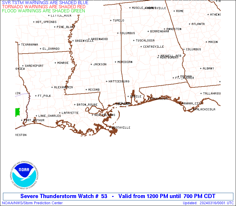
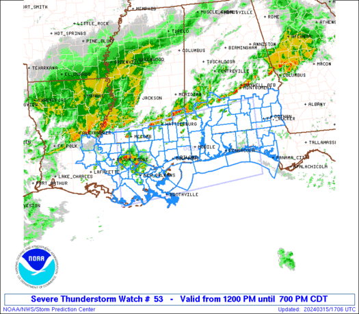
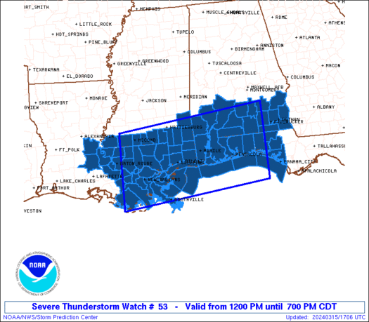
Severe Thunderstorm Watch Number 53
NWS Storm Prediction Center Norman OK
1200 PM CDT Fri Mar 15 2024
The NWS Storm Prediction Center has issued a
* Severe Thunderstorm Watch for portions of
southern Alabama
western portions of the Florida Panhandle
southeastern Louisiana
southern Mississippi
Coastal Waters
* Effective this Friday afternoon and evening from NOON until 700
PM CDT.
* Primary threats include...
Scattered damaging wind gusts to 65 mph likely
Scattered large hail events to 1.5 inches in diameter possible
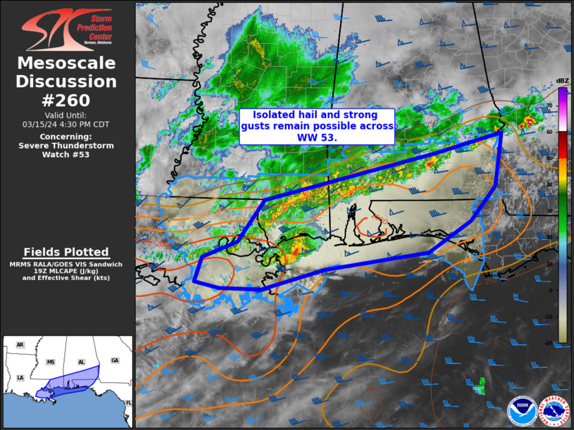
SUMMARY...Thunderstorms are expected to continue increasing in
coverage and intensity this afternoon, with stronger storms/bands
likely to produce damaging wind gusts and hail.
Storms will spread eastward/southeastward with time, weakening --
and gradually moving offshore -- by early evening.
The severe thunderstorm watch area is approximately along and 80
statute miles north and south of a line from 50 miles north
northwest of Houma LA to 30 miles east of Crestview FL. For a
complete depiction of the watch see the associated watch outline
update (WOUS64 KWNS WOU3).
PRECAUTIONARY/PREPAREDNESS ACTIONS...
REMEMBER...A Severe Thunderstorm Watch means conditions are
favorable for severe thunderstorms in and close to the watch area.
Persons in these areas should be on the lookout for threatening
weather conditions and listen for later statements and possible
warnings. Severe thunderstorms can and occasionally do produce
tornadoes.
&&
OTHER WATCH INFORMATION...CONTINUE...WW 52...
AVIATION...A few severe thunderstorms with hail surface and aloft to
1.5 inches. Extreme turbulence and surface wind gusts to 55 knots. A
few cumulonimbi with maximum tops to 500. Mean storm motion vector
27035.
...Goss
   SEL3

   URGENT - IMMEDIATE BROADCAST REQUESTED
   Severe Thunderstorm Watch Number 53
   NWS Storm Prediction Center Norman OK
   1200 PM CDT Fri Mar 15 2024

   The NWS Storm Prediction Center has issued a

   * Severe Thunderstorm Watch for portions of
     southern Alabama
     western portions of the Florida Panhandle
     southeastern Louisiana
     southern Mississippi
     Coastal Waters

   * Effective this Friday afternoon and evening from NOON until 700
     PM CDT.

   * Primary threats include...
     Scattered damaging wind gusts to 65 mph likely
     Scattered large hail events to 1.5 inches in diameter possible

   SUMMARY...Thunderstorms are expected to continue increasing in
   coverage and intensity this afternoon, with stronger storms/bands
   likely to produce damaging wind gusts and hail.
   Storms will spread eastward/southeastward with time, weakening --
   and gradually moving offshore -- by early evening.

   The severe thunderstorm watch area is approximately along and 80
   statute miles north and south of a line from 50 miles north
   northwest of Houma LA to 30 miles east of Crestview FL. For a
   complete depiction of the watch see the associated watch outline
   update (WOUS64 KWNS WOU3).

   PRECAUTIONARY/PREPAREDNESS ACTIONS...

   REMEMBER...A Severe Thunderstorm Watch means conditions are
   favorable for severe thunderstorms in and close to the watch area.
   Persons in these areas should be on the lookout for threatening
   weather conditions and listen for later statements and possible
   warnings. Severe thunderstorms can and occasionally do produce
   tornadoes.

   &&

   OTHER WATCH INFORMATION...CONTINUE...WW 52...

   AVIATION...A few severe thunderstorms with hail surface and aloft to
   1.5 inches. Extreme turbulence and surface wind gusts to 55 knots. A
   few cumulonimbi with maximum tops to 500. Mean storm motion vector
   27035.

   ...Goss
 Note:
The Aviation Watch (SAW) product is an approximation to the watch area.
The actual watch is depicted by the shaded areas.
Note:
The Aviation Watch (SAW) product is an approximation to the watch area.
The actual watch is depicted by the shaded areas.
   SAW3
   WW 53 SEVERE TSTM AL FL LA MS CW 151700Z - 160000Z
   AXIS..80 STATUTE MILES NORTH AND SOUTH OF LINE..
   50NNW HUM/HOUMA LA/ - 30E CEW/CRESTVIEW FL/
   ..AVIATION COORDS.. 70NM N/S /22SE BTR - 34E CEW/
   HAIL SURFACE AND ALOFT..1.5 INCHES. WIND GUSTS..55 KNOTS.
   MAX TOPS TO 500. MEAN STORM MOTION VECTOR 27035.

   LAT...LON 31409099 31948601 29628601 29089099

   THIS IS AN APPROXIMATION TO THE WATCH AREA.  FOR A
   COMPLETE DEPICTION OF THE WATCH SEE WOUS64 KWNS
   FOR WOU3.
Watch 53 Status Report Messages:
STATUS REPORT #5 ON WW 53

VALID 152250Z - 152340Z

SEVERE WEATHER THREAT CONTINUES RIGHT OF A LINE FROM 30 SSE BVE
TO 35 NE BVE TO 35 SE MOB TO 20 N PNS TO 10 WNW DHN TO 35 NE DHN.

..WENDT..03/15/24

ATTN...WFO...MOB...BMX...TAE...LIX...LCH...JAN...

&&

STATUS REPORT FOR WS 53

SEVERE WEATHER THREAT CONTINUES FOR THE FOLLOWING AREAS

ALC045-061-067-069-152340-

AL
.    ALABAMA COUNTIES INCLUDED ARE

DALE		     GENEVA		 HENRY
HOUSTON
$$


FLC005-033-059-091-113-131-133-152340-

FL
.    FLORIDA COUNTIES INCLUDED ARE

BAY		     ESCAMBIA		 HOLMES
OKALOOSA	     SANTA ROSA 	 WALTON
WASHINGTON
$$


GMZ557-633-634-635-636-650-655-750-152340-

CW

.    ADJACENT COASTAL WATERS INCLUDED ARE

COASTAL WATERS FROM PASCAGOULA MISSISSIPPI TO STAKE ISLAND OUT 20
NM

PERDIDO BAY AREA

PENSACOLA BAY AREA INCLUDING SANTA ROSA SOUND

WESTERN CHOCTAWHATCHEE BAY

EASTERN CHOCTAWHATCHEE BAY

COASTAL WATERS FROM PENSACOLA FL TO PASCAGOULA MS OUT 20 NM

COASTAL WATERS FROM OKALOOSA-WALTON COUNTY LINE TO PENSACOLA FL
OUT 20 NM

COASTAL WATERS FROM OKALOOSA-WALTON COUNTY LINE TO MEXICO BEACH
OUT 20 NM

$$
THE WATCH STATUS MESSAGE IS FOR GUIDANCE PURPOSES ONLY.  PLEASE
REFER TO WATCH COUNTY NOTIFICATION STATEMENTS FOR OFFICIAL
INFORMATION ON COUNTIES...INDEPENDENT CITIES AND MARINE ZONES
CLEARED FROM SEVERE THUNDERSTORM AND TORNADO WATCHES.
$$

STATUS REPORT #4 ON WW 53

VALID 152150Z - 152240Z

SEVERE WEATHER THREAT CONTINUES RIGHT OF A LINE FROM 35 WSW BVE
TO 30 NW BVE TO 35 SSW GPT TO 25 E GPT TO 5 NE MOB TO 25 SE GZH
TO 20 SE TOI TO 35 N DHN TO 40 S CSG.

..WENDT..03/15/24

ATTN...WFO...MOB...BMX...TAE...LIX...LCH...JAN...

&&

STATUS REPORT FOR WS 53

SEVERE WEATHER THREAT CONTINUES FOR THE FOLLOWING AREAS

ALC003-005-031-039-045-053-061-067-069-097-152240-

AL
.    ALABAMA COUNTIES INCLUDED ARE

BALDWIN 	     BARBOUR		 COFFEE
COVINGTON	     DALE		 ESCAMBIA
GENEVA		     HENRY		 HOUSTON
MOBILE
$$


FLC005-033-059-091-113-131-133-152240-

FL
.    FLORIDA COUNTIES INCLUDED ARE

BAY		     ESCAMBIA		 HOLMES
OKALOOSA	     SANTA ROSA 	 WALTON
WASHINGTON
$$


LAC075-152240-

LA
.    LOUISIANA PARISHES INCLUDED ARE

PLAQUEMINES
$$


GMZ536-538-557-630-631-632-633-634-635-636-650-655-750-152240-

CW

.    ADJACENT COASTAL WATERS INCLUDED ARE

CHANDELEUR SOUND

BRETON SOUND

COASTAL WATERS FROM PASCAGOULA MISSISSIPPI TO STAKE ISLAND OUT 20
NM

NORTH MOBILE BAY

SOUTH MOBILE BAY

MISSISSIPPI SOUND

PERDIDO BAY AREA

PENSACOLA BAY AREA INCLUDING SANTA ROSA SOUND

WESTERN CHOCTAWHATCHEE BAY

EASTERN CHOCTAWHATCHEE BAY

COASTAL WATERS FROM PENSACOLA FL TO PASCAGOULA MS OUT 20 NM

COASTAL WATERS FROM OKALOOSA-WALTON COUNTY LINE TO PENSACOLA FL
OUT 20 NM

COASTAL WATERS FROM OKALOOSA-WALTON COUNTY LINE TO MEXICO BEACH
OUT 20 NM

$$
THE WATCH STATUS MESSAGE IS FOR GUIDANCE PURPOSES ONLY.  PLEASE
REFER TO WATCH COUNTY NOTIFICATION STATEMENTS FOR OFFICIAL
INFORMATION ON COUNTIES...INDEPENDENT CITIES AND MARINE ZONES
CLEARED FROM SEVERE THUNDERSTORM AND TORNADO WATCHES.
$$

STATUS REPORT #3 ON WW 53

VALID 152040Z - 152140Z

SEVERE WEATHER THREAT CONTINUES RIGHT OF A LINE FROM 40 WNW HUM
TO 30 SSE ASD TO 25 NW MOB TO 20 SW GZH TO 30 SW TOI TO 35 S CSG.

..LEITMAN..03/15/24

ATTN...WFO...MOB...BMX...TAE...LIX...LCH...JAN...

&&

STATUS REPORT FOR WS 53

SEVERE WEATHER THREAT CONTINUES FOR THE FOLLOWING AREAS

ALC003-005-031-039-045-053-061-067-069-097-152140-

AL
.    ALABAMA COUNTIES INCLUDED ARE

BALDWIN 	     BARBOUR		 COFFEE
COVINGTON	     DALE		 ESCAMBIA
GENEVA		     HENRY		 HOUSTON
MOBILE
$$


FLC005-033-059-091-113-131-133-152140-

FL
.    FLORIDA COUNTIES INCLUDED ARE

BAY		     ESCAMBIA		 HOLMES
OKALOOSA	     SANTA ROSA 	 WALTON
WASHINGTON
$$


LAC051-057-075-087-109-152140-

LA
.    LOUISIANA PARISHES INCLUDED ARE

JEFFERSON	     LAFOURCHE		 PLAQUEMINES
ST. BERNARD	     TERREBONNE
$$


MSC039-059-152140-

MS
.    MISSISSIPPI COUNTIES INCLUDED ARE

GEORGE		     JACKSON
$$


GMZ532-534-536-538-557-630-631-632-633-634-635-636-650-655-750-
152140-

CW

.    ADJACENT COASTAL WATERS INCLUDED ARE

MISSISSIPPI SOUND

LAKE BORGNE

CHANDELEUR SOUND

BRETON SOUND

COASTAL WATERS FROM PASCAGOULA MISSISSIPPI TO STAKE ISLAND OUT 20
NM

NORTH MOBILE BAY

SOUTH MOBILE BAY

MISSISSIPPI SOUND

PERDIDO BAY AREA

PENSACOLA BAY AREA INCLUDING SANTA ROSA SOUND

WESTERN CHOCTAWHATCHEE BAY

EASTERN CHOCTAWHATCHEE BAY

COASTAL WATERS FROM PENSACOLA FL TO PASCAGOULA MS OUT 20 NM

COASTAL WATERS FROM OKALOOSA-WALTON COUNTY LINE TO PENSACOLA FL
OUT 20 NM

COASTAL WATERS FROM OKALOOSA-WALTON COUNTY LINE TO MEXICO BEACH
OUT 20 NM

$$
THE WATCH STATUS MESSAGE IS FOR GUIDANCE PURPOSES ONLY.  PLEASE
REFER TO WATCH COUNTY NOTIFICATION STATEMENTS FOR OFFICIAL
INFORMATION ON COUNTIES...INDEPENDENT CITIES AND MARINE ZONES
CLEARED FROM SEVERE THUNDERSTORM AND TORNADO WATCHES.
$$

STATUS REPORT #2 ON WW 53

VALID 151940Z - 152040Z

SEVERE WEATHER THREAT CONTINUES RIGHT OF A LINE FROM 15 ENE LFT
TO 55 NW MSY TO 20 E PIB TO 25 NW GZH TO 10 E TOI TO 25 SSW CSG.

..LEITMAN..03/15/24

ATTN...WFO...MOB...BMX...TAE...LIX...LCH...JAN...

&&

STATUS REPORT FOR WS 53

SEVERE WEATHER THREAT CONTINUES FOR THE FOLLOWING AREAS

ALC003-005-013-025-031-035-039-041-045-053-061-067-069-097-099-
109-129-152040-

AL
.    ALABAMA COUNTIES INCLUDED ARE

BALDWIN 	     BARBOUR		 BUTLER
CLARKE		     COFFEE		 CONECUH
COVINGTON	     CRENSHAW		 DALE
ESCAMBIA	     GENEVA		 HENRY
HOUSTON 	     MOBILE		 MONROE
PIKE		     WASHINGTON
$$


FLC005-033-059-091-113-131-133-152040-

FL
.    FLORIDA COUNTIES INCLUDED ARE

BAY		     ESCAMBIA		 HOLMES
OKALOOSA	     SANTA ROSA 	 WALTON
WASHINGTON
$$


LAC005-007-047-051-057-063-071-075-087-089-093-095-103-105-109-
117-152040-

LA
.    LOUISIANA PARISHES INCLUDED ARE

ASCENSION	     ASSUMPTION 	 IBERVILLE
JEFFERSON	     LAFOURCHE		 LIVINGSTON
ORLEANS 	     PLAQUEMINES	 ST. BERNARD
ST. CHARLES	     ST. JAMES		 ST. JOHN THE BAPTIST
ST. TAMMANY	     TANGIPAHOA 	 TERREBONNE
WASHINGTON
$$


MSC035-039-041-045-047-059-073-109-111-131-152040-

MS
.    MISSISSIPPI COUNTIES INCLUDED ARE

FORREST 	     GEORGE		 GREENE
HANCOCK 	     HARRISON		 JACKSON
LAMAR		     PEARL RIVER	 PERRY
STONE
$$


GMZ530-532-534-536-538-557-630-631-632-633-634-635-636-650-655-
750-152040-

CW

.    ADJACENT COASTAL WATERS INCLUDED ARE

LAKE PONTCHARTRAIN AND LAKE MAUREPAS

MISSISSIPPI SOUND

LAKE BORGNE

CHANDELEUR SOUND

BRETON SOUND

COASTAL WATERS FROM PASCAGOULA MISSISSIPPI TO STAKE ISLAND OUT 20
NM

NORTH MOBILE BAY

SOUTH MOBILE BAY

MISSISSIPPI SOUND

PERDIDO BAY AREA

PENSACOLA BAY AREA INCLUDING SANTA ROSA SOUND

WESTERN CHOCTAWHATCHEE BAY

EASTERN CHOCTAWHATCHEE BAY

COASTAL WATERS FROM PENSACOLA FL TO PASCAGOULA MS OUT 20 NM

COASTAL WATERS FROM OKALOOSA-WALTON COUNTY LINE TO PENSACOLA FL
OUT 20 NM

COASTAL WATERS FROM OKALOOSA-WALTON COUNTY LINE TO MEXICO BEACH
OUT 20 NM

$$
THE WATCH STATUS MESSAGE IS FOR GUIDANCE PURPOSES ONLY.  PLEASE
REFER TO WATCH COUNTY NOTIFICATION STATEMENTS FOR OFFICIAL
INFORMATION ON COUNTIES...INDEPENDENT CITIES AND MARINE ZONES
CLEARED FROM SEVERE THUNDERSTORM AND TORNADO WATCHES.
$$

STATUS REPORT #1 ON WW 53

VALID 151850Z - 151940Z

SEVERE WEATHER THREAT CONTINUES RIGHT OF A LINE FROM 15 NNE LFT
TO 15 SSW MCB TO 25 NE MCB TO 35 W PIB TO 10 NE TOI.

..LEITMAN..03/15/24

ATTN...WFO...MOB...BMX...TAE...LIX...LCH...JAN...

&&

STATUS REPORT FOR WS 53

SEVERE WEATHER THREAT CONTINUES FOR THE FOLLOWING AREAS

ALC003-005-013-025-031-035-039-041-045-053-061-067-069-097-099-
109-129-151940-

AL
.    ALABAMA COUNTIES INCLUDED ARE

BALDWIN 	     BARBOUR		 BUTLER
CLARKE		     COFFEE		 CONECUH
COVINGTON	     CRENSHAW		 DALE
ESCAMBIA	     GENEVA		 HENRY
HOUSTON 	     MOBILE		 MONROE
PIKE		     WASHINGTON
$$


FLC005-033-059-091-113-131-133-151940-

FL
.    FLORIDA COUNTIES INCLUDED ARE

BAY		     ESCAMBIA		 HOLMES
OKALOOSA	     SANTA ROSA 	 WALTON
WASHINGTON
$$


LAC005-007-033-047-051-057-063-071-075-087-089-091-093-095-103-
105-109-117-121-151940-

LA
.    LOUISIANA PARISHES INCLUDED ARE

ASCENSION	     ASSUMPTION 	 EAST BATON ROUGE
IBERVILLE	     JEFFERSON		 LAFOURCHE
LIVINGSTON	     ORLEANS		 PLAQUEMINES
ST. BERNARD	     ST. CHARLES	 ST. HELENA
ST. JAMES	     ST. JOHN THE BAPTISTST. TAMMANY
TANGIPAHOA	     TERREBONNE 	 WASHINGTON
WEST BATON ROUGE
$$


MSC035-039-041-045-047-059-073-091-109-111-113-131-147-153-
151940-

MS
.    MISSISSIPPI COUNTIES INCLUDED ARE

FORREST 	     GEORGE		 GREENE
HANCOCK 	     HARRISON		 JACKSON
LAMAR		     MARION		 PEARL RIVER
PERRY		     PIKE		 STONE
WALTHALL	     WAYNE
$$


GMZ530-532-534-536-538-557-630-631-632-633-634-635-636-650-655-
750-151940-

CW

.    ADJACENT COASTAL WATERS INCLUDED ARE

LAKE PONTCHARTRAIN AND LAKE MAUREPAS

MISSISSIPPI SOUND

LAKE BORGNE

CHANDELEUR SOUND

BRETON SOUND

COASTAL WATERS FROM PASCAGOULA MISSISSIPPI TO STAKE ISLAND OUT 20
NM

NORTH MOBILE BAY

SOUTH MOBILE BAY

MISSISSIPPI SOUND

PERDIDO BAY AREA

PENSACOLA BAY AREA INCLUDING SANTA ROSA SOUND

WESTERN CHOCTAWHATCHEE BAY

EASTERN CHOCTAWHATCHEE BAY

COASTAL WATERS FROM PENSACOLA FL TO PASCAGOULA MS OUT 20 NM

COASTAL WATERS FROM OKALOOSA-WALTON COUNTY LINE TO PENSACOLA FL
OUT 20 NM

COASTAL WATERS FROM OKALOOSA-WALTON COUNTY LINE TO MEXICO BEACH
OUT 20 NM

$$
THE WATCH STATUS MESSAGE IS FOR GUIDANCE PURPOSES ONLY.  PLEASE
REFER TO WATCH COUNTY NOTIFICATION STATEMENTS FOR OFFICIAL
INFORMATION ON COUNTIES...INDEPENDENT CITIES AND MARINE ZONES
CLEARED FROM SEVERE THUNDERSTORM AND TORNADO WATCHES.
$$
Note:
Click for Complete Product Text.
Tornadoes
Probability of 2 or more tornadoes
|
Low (10%)
|
Probability of 1 or more strong (EF2-EF5) tornadoes
|
Low (<2%)
|
Wind
Probability of 10 or more severe wind events
|
Mod (60%)
|
Probability of 1 or more wind events > 65 knots
|
Low (20%)
|
Hail
Probability of 10 or more severe hail events
|
Mod (40%)
|
Probability of 1 or more hailstones > 2 inches
|
Low (20%)
|
Combined Severe Hail/Wind
Probability of 6 or more combined severe hail/wind events
|
High (90%)
|
For each watch, probabilities for particular events inside the watch
(listed above in each table) are determined by the issuing forecaster.
The "Low" category contains probability values ranging from less than 2%
to 20% (EF2-EF5 tornadoes), less than 5% to 20% (all other probabilities),
"Moderate" from 30% to 60%, and "High" from 70% to greater than 95%.
High values are bolded and lighter in color to provide awareness of
an increased threat for a particular event.


 @NWSSPC