Note:
The expiration time in the watch graphic is amended if the watch is
replaced, cancelled or extended.
Note:
Note:
The expiration time in the watch graphic is amended if the watch is
replaced, cancelled or extended.
Note: Click for
Watch Status Reports.
SEL8
URGENT - IMMEDIATE BROADCAST REQUESTED
Tornado Watch Number 178
NWS Storm Prediction Center Norman OK
210 PM CDT Fri May 3 2024
The NWS Storm Prediction Center has issued a
* Tornado Watch for portions of
Northwest into West Texas
* Effective this Friday afternoon and evening from 210 PM until
1000 PM CDT.
* Primary threats include...
A few tornadoes and a couple intense tornadoes possible
Scattered large hail and isolated very large hail events to 4.5
inches in diameter likely
Scattered damaging winds likely with isolated significant gusts
to 75 mph possible
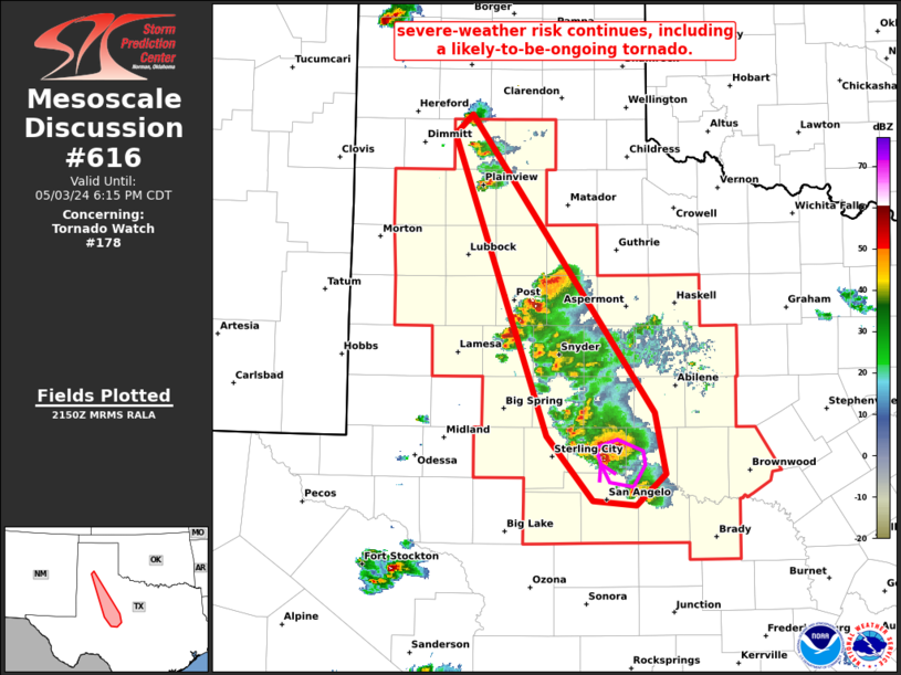
SUMMARY...Scattered severe thunderstorms are forecast to develop
this afternoon into the evening across portions of the Watch area.
Several intense supercells are likely to evolve and pose a risk for
giant hail and tornadoes. The tornado risk will probably be
greatest in the vicinity of a modifying boundary draped across the
region.
The tornado watch area is approximately along and 75 statute miles
north and south of a line from 45 miles west southwest of Lubbock TX
to 60 miles southeast of Abilene TX. For a complete depiction of the
watch see the associated watch outline update (WOUS64 KWNS WOU8).
PRECAUTIONARY/PREPAREDNESS ACTIONS...
REMEMBER...A Tornado Watch means conditions are favorable for
tornadoes and severe thunderstorms in and close to the watch
area. Persons in these areas should be on the lookout for
threatening weather conditions and listen for later statements
and possible warnings.
&&
AVIATION...Tornadoes and a few severe thunderstorms with hail
surface and aloft to 4.5 inches. Extreme turbulence and surface wind
gusts to 65 knots. A few cumulonimbi with maximum tops to 500. Mean
storm motion vector 28020.
...Smith
 Note:
The Aviation Watch (SAW) product is an approximation to the watch area.
The actual watch is depicted by the shaded areas.
Note:
The Aviation Watch (SAW) product is an approximation to the watch area.
The actual watch is depicted by the shaded areas.
   SAW8
   WW 178 TORNADO TX 031910Z - 040300Z
   AXIS..75 STATUTE MILES NORTH AND SOUTH OF LINE..
   45WSW LBB/LUBBOCK TX/ - 60SE ABI/ABILENE TX/
   ..AVIATION COORDS.. 65NM N/S /35WSW LBB - 61SE ABI/
   HAIL SURFACE AND ALOFT..4.5 INCHES. WIND GUSTS..65 KNOTS.
   MAX TOPS TO 500. MEAN STORM MOTION VECTOR 28020.

   LAT...LON 34500254 32899896 30729896 32330254

   THIS IS AN APPROXIMATION TO THE WATCH AREA.  FOR A
   COMPLETE DEPICTION OF THE WATCH SEE WOUS64 KWNS
   FOR WOU8.
Watch 178 Status Report Messages:
STATUS REPORT #4 ON WW 178

VALID 040145Z - 040240Z

SEVERE WEATHER THREAT CONTINUES RIGHT OF A LINE FROM 35 SSE BGS
TO 55 NE BGS TO 50 NNE ABI.

..GOSS..05/04/24

ATTN...WFO...MAF...SJT...LUB...

&&

STATUS REPORT FOR WT 178

SEVERE WEATHER THREAT CONTINUES FOR THE FOLLOWING AREAS

TXC049-059-081-083-095-151-207-235-253-307-353-399-417-431-441-
451-040240-

TX
.    TEXAS COUNTIES INCLUDED ARE

BROWN		     CALLAHAN		 COKE
COLEMAN 	     CONCHO		 FISHER
HASKELL 	     IRION		 JONES
MCCULLOCH	     NOLAN		 RUNNELS
SHACKELFORD	     STERLING		 TAYLOR
TOM GREEN
$$


THE WATCH STATUS MESSAGE IS FOR GUIDANCE PURPOSES ONLY.  PLEASE
REFER TO WATCH COUNTY NOTIFICATION STATEMENTS FOR OFFICIAL
INFORMATION ON COUNTIES...INDEPENDENT CITIES AND MARINE ZONES
CLEARED FROM SEVERE THUNDERSTORM AND TORNADO WATCHES.
$$

STATUS REPORT #3 ON WW 178

VALID 040040Z - 040140Z

SEVERE WEATHER THREAT CONTINUES RIGHT OF A LINE FROM 15 E MAF TO
60 NE BGS TO 35 ESE PVW.

..GOSS..05/04/24

ATTN...WFO...MAF...SJT...LUB...

&&

STATUS REPORT FOR WT 178

SEVERE WEATHER THREAT CONTINUES FOR THE FOLLOWING AREAS

TXC045-049-059-081-083-095-125-151-207-235-253-263-307-353-399-
417-431-433-441-451-040140-

TX
.    TEXAS COUNTIES INCLUDED ARE

BRISCOE 	     BROWN		 CALLAHAN
COKE		     COLEMAN		 CONCHO
DICKENS 	     FISHER		 HASKELL
IRION		     JONES		 KENT
MCCULLOCH	     NOLAN		 RUNNELS
SHACKELFORD	     STERLING		 STONEWALL
TAYLOR		     TOM GREEN
$$


THE WATCH STATUS MESSAGE IS FOR GUIDANCE PURPOSES ONLY.  PLEASE
REFER TO WATCH COUNTY NOTIFICATION STATEMENTS FOR OFFICIAL
INFORMATION ON COUNTIES...INDEPENDENT CITIES AND MARINE ZONES
CLEARED FROM SEVERE THUNDERSTORM AND TORNADO WATCHES.
$$

STATUS REPORT #2 ON WW 178

VALID 032130Z - 032240Z

THE SEVERE WEATHER THREAT CONTINUES ACROSS THE ENTIRE WATCH AREA.

..GOSS..05/03/24

ATTN...WFO...MAF...SJT...LUB...

&&

STATUS REPORT FOR WT 178

SEVERE WEATHER THREAT CONTINUES FOR THE FOLLOWING AREAS

TXC033-049-059-081-083-095-107-115-125-151-153-169-173-189-207-
219-227-235-253-263-279-303-305-307-335-353-399-415-417-431-433-
441-445-451-032240-

TX
.    TEXAS COUNTIES INCLUDED ARE

BORDEN		     BROWN		 CALLAHAN
COKE		     COLEMAN		 CONCHO
CROSBY		     DAWSON		 DICKENS
FISHER		     FLOYD		 GARZA
GLASSCOCK	     HALE		 HASKELL
HOCKLEY 	     HOWARD		 IRION
JONES		     KENT		 LAMB
LUBBOCK 	     LYNN		 MCCULLOCH
MITCHELL	     NOLAN		 RUNNELS
SCURRY		     SHACKELFORD	 STERLING
STONEWALL	     TAYLOR		 TERRY
TOM GREEN
$$


THE WATCH STATUS MESSAGE IS FOR GUIDANCE PURPOSES ONLY.  PLEASE
REFER TO WATCH COUNTY NOTIFICATION STATEMENTS FOR OFFICIAL
INFORMATION ON COUNTIES...INDEPENDENT CITIES AND MARINE ZONES
CLEARED FROM SEVERE THUNDERSTORM AND TORNADO WATCHES.
$$

STATUS REPORT #1 ON WW 178

VALID 032030Z - 032140Z

THE SEVERE WEATHER THREAT CONTINUES ACROSS THE ENTIRE WATCH AREA.

..KERR..05/03/24

ATTN...WFO...MAF...SJT...LUB...

&&

STATUS REPORT FOR WT 178

SEVERE WEATHER THREAT CONTINUES FOR THE FOLLOWING AREAS

TXC033-049-059-081-083-095-107-115-125-151-153-169-173-189-207-
219-227-235-253-263-279-303-305-307-335-353-399-415-417-431-433-
441-445-451-032140-

TX
.    TEXAS COUNTIES INCLUDED ARE

BORDEN		     BROWN		 CALLAHAN
COKE		     COLEMAN		 CONCHO
CROSBY		     DAWSON		 DICKENS
FISHER		     FLOYD		 GARZA
GLASSCOCK	     HALE		 HASKELL
HOCKLEY 	     HOWARD		 IRION
JONES		     KENT		 LAMB
LUBBOCK 	     LYNN		 MCCULLOCH
MITCHELL	     NOLAN		 RUNNELS
SCURRY		     SHACKELFORD	 STERLING
STONEWALL	     TAYLOR		 TERRY
TOM GREEN
$$


THE WATCH STATUS MESSAGE IS FOR GUIDANCE PURPOSES ONLY.  PLEASE
REFER TO WATCH COUNTY NOTIFICATION STATEMENTS FOR OFFICIAL
INFORMATION ON COUNTIES...INDEPENDENT CITIES AND MARINE ZONES
CLEARED FROM SEVERE THUNDERSTORM AND TORNADO WATCHES.
$$
Note:
Click for Complete Product Text.
Tornadoes
Probability of 2 or more tornadoes
|
Mod (50%)
|
Probability of 1 or more strong (EF2-EF5) tornadoes
|
Mod (30%)
|
Wind
Probability of 10 or more severe wind events
|
Mod (60%)
|
Probability of 1 or more wind events > 65 knots
|
Mod (30%)
|
Hail
Probability of 10 or more severe hail events
|
High (70%)
|
Probability of 1 or more hailstones > 2 inches
|
High (70%)
|
Combined Severe Hail/Wind
Probability of 6 or more combined severe hail/wind events
|
High (>95%)
|
For each watch, probabilities for particular events inside the watch
(listed above in each table) are determined by the issuing forecaster.
The "Low" category contains probability values ranging from less than 2%
to 20% (EF2-EF5 tornadoes), less than 5% to 20% (all other probabilities),
"Moderate" from 30% to 60%, and "High" from 70% to greater than 95%.
High values are bolded and lighter in color to provide awareness of
an increased threat for a particular event.


 @NWSSPC