|
| Mesoscale Discussion 616 |
|
< Previous MD Next MD >
|
|
Mesoscale Discussion 0616
NWS Storm Prediction Center Norman OK
0452 PM CDT Fri May 03 2024
Areas affected...west-central Texas...from the South Plains to the
Concho Valley
Concerning...Tornado Watch 178...
Valid 032152Z - 032315Z
The severe weather threat for Tornado Watch 178 continues.
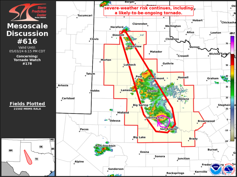
SUMMARY...Severe/isolated tornado risk continues across Tornado
Watch 178, including a very intense/strongly rotating supercell
moving southeastward across Coke County north of San Angelo.
DISCUSSION...Latest radar loop shows isolated storms extending from
north of Lubbock southeastward to near San Angelo. Given the very
favorable thermodynamic environment (2500 to 3500 J/kg mixed-layer
CAPE per RAP-based objective analysis) across the area, and
low-level southeasterlies veering to west-southwesterly at mid
levels, risk for very large hail, locally damaging winds, and
isolated tornadoes continues.
One storm in particular appears strongly tornadic at this time per
radar observations. In addition to an extremely well-defined hook
with an eye-like area of lesser reflectivity apparent, the latest
storm-relative velocity data from the KSJT WSR-88D shows rotational
velocity in excess of 90kt -- coincident with the "reflectivity eye"
within the hook, would suggest the possibility of an ongoing
significant tornado. While this storm is currently moving
southeastward across relatively sparsely populated areas, continued
southeastward motion could allow the storm to approach areas near
and east of the San Angelo area in the next hour. With that said, a
recent turn to a more east-southeastward motion has been observed in
the past couple of volume scans.
..Goss.. 05/03/2024
...Please see www.spc.noaa.gov for graphic product...
ATTN...WFO...SJT...LUB...AMA...MAF...
LAT...LON 32000104 34620199 34780180 32209994 31689983 31400012
31450056 32000104
|
|
Top/All Mesoscale Discussions/Forecast Products/Home
|
|


 @NWSSPC