 Note:
The expiration time in the watch graphic is amended if the watch is
replaced, cancelled or extended.
Note:
Note:
The expiration time in the watch graphic is amended if the watch is
replaced, cancelled or extended.
Note: Click for
Watch Status Reports.
SEL7
URGENT - IMMEDIATE BROADCAST REQUESTED
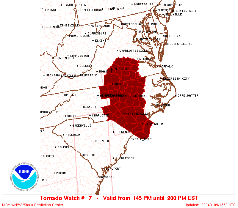
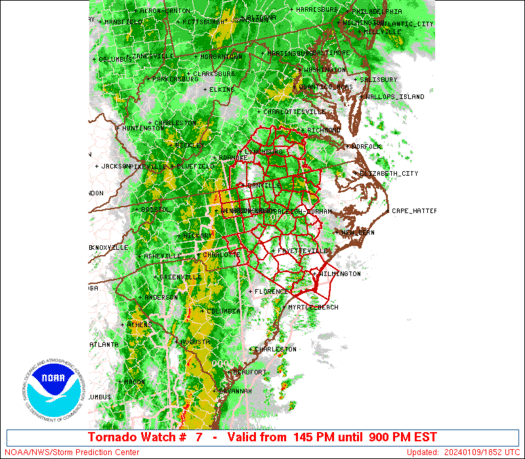
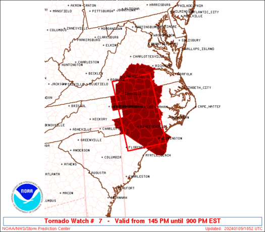
Tornado Watch Number 7
NWS Storm Prediction Center Norman OK
145 PM EST Tue Jan 9 2024
The NWS Storm Prediction Center has issued a
* Tornado Watch for portions of
Central North Carolina
South-central Virginia
Coastal Waters
* Effective this Tuesday afternoon and evening from 145 PM until
900 PM EST.
* Primary threats include...
A few tornadoes likely with a couple intense tornadoes possible
Scattered damaging wind gusts to 70 mph likely
SUMMARY...A fast-moving line of thunderstorms over western North
Carolina will track eastward this afternoon, posing a risk of
damaging wind gusts and a few brief tornadoes. This line is
expected to build northward with time into central and southeast
Virginia.
The tornado watch area is approximately along and 60 statute miles
east and west of a line from 50 miles northwest of South Hill VA to
45 miles west southwest of Wilmington NC. For a complete depiction
of the watch see the associated watch outline update (WOUS64 KWNS
WOU7).
PRECAUTIONARY/PREPAREDNESS ACTIONS...
REMEMBER...A Tornado Watch means conditions are favorable for
tornadoes and severe thunderstorms in and close to the watch
area. Persons in these areas should be on the lookout for
threatening weather conditions and listen for later statements
and possible warnings.
&&
OTHER WATCH INFORMATION...CONTINUE...WW 4...WW 5...WW 6...
AVIATION...Tornadoes and a few severe thunderstorms with hail
surface and aloft to 1 inch. Extreme turbulence and surface wind
gusts to 60 knots. A few cumulonimbi with maximum tops to 400. Mean
storm motion vector 24040.
...Hart
   SEL7

   URGENT - IMMEDIATE BROADCAST REQUESTED
   Tornado Watch Number 7
   NWS Storm Prediction Center Norman OK
   145 PM EST Tue Jan 9 2024

   The NWS Storm Prediction Center has issued a

   * Tornado Watch for portions of
     Central North Carolina
     South-central Virginia
     Coastal Waters

   * Effective this Tuesday afternoon and evening from 145 PM until
     900 PM EST.

   * Primary threats include...
     A few tornadoes likely with a couple intense tornadoes possible
     Scattered damaging wind gusts to 70 mph likely

   SUMMARY...A fast-moving line of thunderstorms over western North
   Carolina will track eastward this afternoon, posing a risk of
   damaging wind gusts and a few brief tornadoes.  This line is
   expected to build northward with time into central and southeast
   Virginia.

   The tornado watch area is approximately along and 60 statute miles
   east and west of a line from 50 miles northwest of South Hill VA to
   45 miles west southwest of Wilmington NC. For a complete depiction
   of the watch see the associated watch outline update (WOUS64 KWNS
   WOU7).

   PRECAUTIONARY/PREPAREDNESS ACTIONS...

   REMEMBER...A Tornado Watch means conditions are favorable for
   tornadoes and severe thunderstorms in and close to the watch
   area. Persons in these areas should be on the lookout for
   threatening weather conditions and listen for later statements
   and possible warnings.

   &&

   OTHER WATCH INFORMATION...CONTINUE...WW 4...WW 5...WW 6...

   AVIATION...Tornadoes and a few severe thunderstorms with hail
   surface and aloft to 1 inch. Extreme turbulence and surface wind
   gusts to 60 knots. A few cumulonimbi with maximum tops to 400. Mean
   storm motion vector 24040.

   ...Hart
 Note:
The Aviation Watch (SAW) product is an approximation to the watch area.
The actual watch is depicted by the shaded areas.
Note:
The Aviation Watch (SAW) product is an approximation to the watch area.
The actual watch is depicted by the shaded areas.
   SAW7
   WW 7 TORNADO NC VA CW 091845Z - 100200Z
   AXIS..60 STATUTE MILES EAST AND WEST OF LINE..
   50NW AVC/SOUTH HILL VA/ - 45WSW ILM/WILMINGTON NC/
   ..AVIATION COORDS.. 50NM E/W /26E LYH - 42WSW ILM/
   HAIL SURFACE AND ALOFT..1 INCH. WIND GUSTS..60 KNOTS.
   MAX TOPS TO 400. MEAN STORM MOTION VECTOR 24040.

   LAT...LON 37187760 34007758 34007967 37187978

   THIS IS AN APPROXIMATION TO THE WATCH AREA.  FOR A
   COMPLETE DEPICTION OF THE WATCH SEE WOUS64 KWNS
   FOR WOU7.
Watch 7 Status Report Messages:
STATUS REPORT #6 ON WW 7

VALID 100030Z - 100140Z

SEVERE WEATHER THREAT CONTINUES RIGHT OF A LINE FROM 30 ENE CRE
TO 15 NNW OAJ TO 20 WSW RIC.

..THORNTON..01/10/24

ATTN...WFO...RAH...ILM...RNK...MHX...AKQ...

&&

STATUS REPORT FOR WT 7

SEVERE WEATHER THREAT CONTINUES FOR THE FOLLOWING AREAS

NCC013-015-019-029-031-041-049-053-055-065-073-083-091-095-103-
107-117-129-131-137-139-141-143-147-177-187-100140-

NC
.    NORTH CAROLINA COUNTIES INCLUDED ARE

BEAUFORT	     BERTIE		 BRUNSWICK
CAMDEN		     CARTERET		 CHOWAN
CRAVEN		     CURRITUCK		 DARE
EDGECOMBE	     GATES		 HALIFAX
HERTFORD	     HYDE		 JONES
LENOIR		     MARTIN		 NEW HANOVER
NORTHAMPTON	     PAMLICO		 PASQUOTANK
PENDER		     PERQUIMANS 	 PITT
TYRRELL 	     WASHINGTON
$$


VAC036-041-053-081-087-093-095-149-175-181-183-199-550-570-595-
620-650-670-700-710-730-735-740-760-800-810-830-100140-

VA
.    VIRGINIA COUNTIES INCLUDED ARE

CHARLES CITY	     CHESTERFIELD	 DINWIDDIE
GREENSVILLE	     HENRICO		 ISLE OF WIGHT
JAMES CITY	     PRINCE GEORGE	 SOUTHAMPTON
SURRY		     SUSSEX		 YORK


VIRGINIA INDEPENDENT CITIES INCLUDED ARE

CHESAPEAKE	     COLONIAL HEIGHTS	 EMPORIA
FRANKLIN	     HAMPTON		 HOPEWELL
NEWPORT NEWS	     NORFOLK		 PETERSBURG
POQUOSON	     PORTSMOUTH 	 RICHMOND
SUFFOLK 	     VIRGINIA BEACH	 WILLIAMSBURG
$$


AMZ131-135-150-152-154-156-158-230-231-250-252-ANZ632-633-634-637-
638-656-658-100140-

CW

.    ADJACENT COASTAL WATERS INCLUDED ARE

ALLIGATOR RIVER

PAMLICO SOUND

S OF CURRITUCK BEACH LIGHT NC TO OREGON INLET NC OUT TO 20 NM

S OF OREGON INLET NC TO CAPE HATTERAS NC OUT TO 20 NM

S OF CAPE HATTERAS NC TO OCRACOKE INLET NC OUT TO 20 NM

S OF OCRACOKE INLET NC TO CAPE LOOKOUT NC OUT TO 20 NM

S OF CAPE LOOKOUT NC TO SURF CITY NC OUT TO 20 NM

ALBEMARLE SOUND

CROATAN AND ROANOKE SOUNDS

COASTAL WATERS FROM SURF CITY TO CAPE FEAR NC OUT 20 NM

COASTAL WATERS FROM CAPE FEAR NC TO LITTLE RIVER INLET SC OUT 20
NM

CHESAPEAKE BAY FROM NEW POINT COMFORT TO LITTLE CREEK VA

CURRITUCK SOUND

CHESAPEAKE BAY FROM LITTLE CREEK VA TO CAPE HENRY VA INCLUDING
THE CHESAPEAKE BAY BRIDGE TUNNEL

JAMES RIVER FROM JAMESTOWN TO THE JAMES RIVER BRIDGE

JAMES RIVER FROM JAMES RIVER BRIDGE TO HAMPTON ROADS
BRIDGE-TUNNEL

COASTAL WATERS FROM CAPE CHARLES LIGHT TO VIRGINIA-NORTH CAROLINA
BORDER OUT TO 20 NM

COASTAL WATERS FROM NC VA BORDER TO CURRITUCK BEACH LIGHT NC OUT
20 NM

$$
THE WATCH STATUS MESSAGE IS FOR GUIDANCE PURPOSES ONLY.  PLEASE
REFER TO WATCH COUNTY NOTIFICATION STATEMENTS FOR OFFICIAL
INFORMATION ON COUNTIES...INDEPENDENT CITIES AND MARINE ZONES
CLEARED FROM SEVERE THUNDERSTORM AND TORNADO WATCHES.
$$

STATUS REPORT #5 ON WW 7

VALID 092335Z - 100040Z

SEVERE WEATHER THREAT CONTINUES RIGHT OF A LINE FROM 25 WNW CRE
TO 15 SSE FAY TO 30 NW RIC.

..THORNTON..01/09/24

ATTN...WFO...RAH...ILM...RNK...MHX...AKQ...

&&

STATUS REPORT FOR WT 7

SEVERE WEATHER THREAT CONTINUES FOR THE FOLLOWING AREAS

NCC013-015-017-019-031-041-047-049-061-065-073-079-083-091-101-
103-107-117-127-129-131-137-141-147-163-185-187-191-195-
100040-

NC
.    NORTH CAROLINA COUNTIES INCLUDED ARE

BEAUFORT	     BERTIE		 BLADEN
BRUNSWICK	     CARTERET		 CHOWAN
COLUMBUS	     CRAVEN		 DUPLIN
EDGECOMBE	     GATES		 GREENE
HALIFAX 	     HERTFORD		 JOHNSTON
JONES		     LENOIR		 MARTIN
NASH		     NEW HANOVER	 NORTHAMPTON
PAMLICO 	     PENDER		 PITT
SAMPSON 	     WARREN		 WASHINGTON
WAYNE		     WILSON
$$


VAC025-036-041-053-081-087-093-095-149-175-181-183-199-570-595-
620-650-670-700-730-760-800-830-100040-

VA
.    VIRGINIA COUNTIES INCLUDED ARE

BRUNSWICK	     CHARLES CITY	 CHESTERFIELD
DINWIDDIE	     GREENSVILLE	 HENRICO
ISLE OF WIGHT	     JAMES CITY 	 PRINCE GEORGE
SOUTHAMPTON	     SURRY		 SUSSEX
YORK


VIRGINIA INDEPENDENT CITIES INCLUDED ARE

COLONIAL HEIGHTS     EMPORIA		 FRANKLIN
HAMPTON 	     HOPEWELL		 NEWPORT NEWS
PETERSBURG	     RICHMOND		 SUFFOLK
WILLIAMSBURG
$$


AMZ158-250-252-ANZ637-638-100040-

CW

.    ADJACENT COASTAL WATERS INCLUDED ARE

S OF CAPE LOOKOUT NC TO SURF CITY NC OUT TO 20 NM

COASTAL WATERS FROM SURF CITY TO CAPE FEAR NC OUT 20 NM

COASTAL WATERS FROM CAPE FEAR NC TO LITTLE RIVER INLET SC OUT 20
NM

JAMES RIVER FROM JAMESTOWN TO THE JAMES RIVER BRIDGE

JAMES RIVER FROM JAMES RIVER BRIDGE TO HAMPTON ROADS
BRIDGE-TUNNEL

$$
THE WATCH STATUS MESSAGE IS FOR GUIDANCE PURPOSES ONLY.  PLEASE
REFER TO WATCH COUNTY NOTIFICATION STATEMENTS FOR OFFICIAL
INFORMATION ON COUNTIES...INDEPENDENT CITIES AND MARINE ZONES
CLEARED FROM SEVERE THUNDERSTORM AND TORNADO WATCHES.
$$

STATUS REPORT #4 ON WW 7

VALID 092230Z - 092340Z

SEVERE WEATHER THREAT CONTINUES RIGHT OF A LINE FROM 15 NNW FLO
TO 25 SW RDU TO 40 E LYH.

FOR ADDITIONAL INFORMATION SEE MESOSCALE DISCUSSION 38

..THORNTON..01/09/24

ATTN...WFO...RAH...ILM...RNK...MHX...AKQ...

&&

STATUS REPORT FOR WT 7

SEVERE WEATHER THREAT CONTINUES FOR THE FOLLOWING AREAS

NCC017-019-031-047-049-051-061-063-065-069-077-079-083-085-093-
101-103-107-127-129-131-137-141-155-163-165-181-183-185-191-195-
092340-

NC
.    NORTH CAROLINA COUNTIES INCLUDED ARE

BLADEN		     BRUNSWICK		 CARTERET
COLUMBUS	     CRAVEN		 CUMBERLAND
DUPLIN		     DURHAM		 EDGECOMBE
FRANKLIN	     GRANVILLE		 GREENE
HALIFAX 	     HARNETT		 HOKE
JOHNSTON	     JONES		 LENOIR
NASH		     NEW HANOVER	 NORTHAMPTON
PAMLICO 	     PENDER		 ROBESON
SAMPSON 	     SCOTLAND		 VANCE
WAKE		     WARREN		 WAYNE
WILSON
$$


VAC007-025-041-049-053-081-111-117-135-145-147-570-595-730-
092340-

VA
.    VIRGINIA COUNTIES INCLUDED ARE

AMELIA		     BRUNSWICK		 CHESTERFIELD
CUMBERLAND	     DINWIDDIE		 GREENSVILLE
LUNENBURG	     MECKLENBURG	 NOTTOWAY
POWHATAN	     PRINCE EDWARD


VIRGINIA INDEPENDENT CITIES INCLUDED ARE

COLONIAL HEIGHTS     EMPORIA		 PETERSBURG
$$


AMZ158-250-252-092340-

CW

.    ADJACENT COASTAL WATERS INCLUDED ARE

S OF CAPE LOOKOUT NC TO SURF CITY NC OUT TO 20 NM

COASTAL WATERS FROM SURF CITY TO CAPE FEAR NC OUT 20 NM

COASTAL WATERS FROM CAPE FEAR NC TO LITTLE RIVER INLET SC OUT 20
NM

$$
THE WATCH STATUS MESSAGE IS FOR GUIDANCE PURPOSES ONLY.  PLEASE
REFER TO WATCH COUNTY NOTIFICATION STATEMENTS FOR OFFICIAL
INFORMATION ON COUNTIES...INDEPENDENT CITIES AND MARINE ZONES
CLEARED FROM SEVERE THUNDERSTORM AND TORNADO WATCHES.
$$

STATUS REPORT #3 ON WW 7

VALID 092130Z - 092240Z

SEVERE WEATHER THREAT CONTINUES RIGHT OF A LINE FROM 35 SSW GSO
TO 20 ESE GSO TO 25 NNE DAN TO 45 E LYH.

FOR ADDITIONAL INFORMATION SEE MESOSCALE DISCUSSION 38

..THORNTON..01/09/24

ATTN...WFO...RAH...ILM...RNK...MHX...AKQ...

&&

STATUS REPORT FOR WT 7

SEVERE WEATHER THREAT CONTINUES FOR THE FOLLOWING AREAS

NCC001-017-019-031-037-047-049-051-061-063-065-069-077-079-083-
085-093-101-103-105-107-123-125-127-129-131-135-137-141-145-153-
155-163-165-181-183-185-191-195-092240-

NC
.    NORTH CAROLINA COUNTIES INCLUDED ARE

ALAMANCE	     BLADEN		 BRUNSWICK
CARTERET	     CHATHAM		 COLUMBUS
CRAVEN		     CUMBERLAND 	 DUPLIN
DURHAM		     EDGECOMBE		 FRANKLIN
GRANVILLE	     GREENE		 HALIFAX
HARNETT 	     HOKE		 JOHNSTON
JONES		     LEE		 LENOIR
MONTGOMERY	     MOORE		 NASH
NEW HANOVER	     NORTHAMPTON	 ORANGE
PAMLICO 	     PENDER		 PERSON
RICHMOND	     ROBESON		 SAMPSON
SCOTLAND	     VANCE		 WAKE
WARREN		     WAYNE		 WILSON
$$


VAC007-025-041-049-053-081-083-111-117-135-145-147-570-595-730-
092240-

VA
.    VIRGINIA COUNTIES INCLUDED ARE

AMELIA		     BRUNSWICK		 CHESTERFIELD
CUMBERLAND	     DINWIDDIE		 GREENSVILLE
HALIFAX 	     LUNENBURG		 MECKLENBURG
NOTTOWAY	     POWHATAN		 PRINCE EDWARD


VIRGINIA INDEPENDENT CITIES INCLUDED ARE

COLONIAL HEIGHTS     EMPORIA		 PETERSBURG
$$


AMZ158-250-252-092240-

CW

.    ADJACENT COASTAL WATERS INCLUDED ARE

S OF CAPE LOOKOUT NC TO SURF CITY NC OUT TO 20 NM

COASTAL WATERS FROM SURF CITY TO CAPE FEAR NC OUT 20 NM

COASTAL WATERS FROM CAPE FEAR NC TO LITTLE RIVER INLET SC OUT 20
NM

$$
THE WATCH STATUS MESSAGE IS FOR GUIDANCE PURPOSES ONLY.  PLEASE
REFER TO WATCH COUNTY NOTIFICATION STATEMENTS FOR OFFICIAL
INFORMATION ON COUNTIES...INDEPENDENT CITIES AND MARINE ZONES
CLEARED FROM SEVERE THUNDERSTORM AND TORNADO WATCHES.
$$

STATUS REPORT #2 ON WW 7

VALID 092030Z - 092140Z

THE SEVERE WEATHER THREAT CONTINUES ACROSS THE ENTIRE WATCH AREA.

..THORNTON..01/09/24

ATTN...WFO...RAH...ILM...RNK...MHX...AKQ...

&&

STATUS REPORT FOR WT 7

SEVERE WEATHER THREAT CONTINUES FOR THE FOLLOWING AREAS

NCC001-017-019-033-037-047-051-061-063-065-069-077-079-081-083-
085-093-101-105-107-123-125-127-129-131-135-141-145-153-155-157-
163-165-181-183-185-191-195-092140-

NC
.    NORTH CAROLINA COUNTIES INCLUDED ARE

ALAMANCE	     BLADEN		 BRUNSWICK
CASWELL 	     CHATHAM		 COLUMBUS
CUMBERLAND	     DUPLIN		 DURHAM
EDGECOMBE	     FRANKLIN		 GRANVILLE
GREENE		     GUILFORD		 HALIFAX
HARNETT 	     HOKE		 JOHNSTON
LEE		     LENOIR		 MONTGOMERY
MOORE		     NASH		 NEW HANOVER
NORTHAMPTON	     ORANGE		 PENDER
PERSON		     RICHMOND		 ROBESON
ROCKINGHAM	     SAMPSON		 SCOTLAND
VANCE		     WAKE		 WARREN
WAYNE		     WILSON
$$


VAC007-011-025-029-031-037-041-049-053-081-083-111-117-135-143-
145-147-570-590-595-730-092140-

VA
.    VIRGINIA COUNTIES INCLUDED ARE

AMELIA		     APPOMATTOX 	 BRUNSWICK
BUCKINGHAM	     CAMPBELL		 CHARLOTTE
CHESTERFIELD	     CUMBERLAND 	 DINWIDDIE
GREENSVILLE	     HALIFAX		 LUNENBURG
MECKLENBURG	     NOTTOWAY		 PITTSYLVANIA
POWHATAN	     PRINCE EDWARD


VIRGINIA INDEPENDENT CITIES INCLUDED ARE

COLONIAL HEIGHTS     DANVILLE		 EMPORIA
PETERSBURG
$$


AMZ250-252-092140-

CW

.    ADJACENT COASTAL WATERS INCLUDED ARE

COASTAL WATERS FROM SURF CITY TO CAPE FEAR NC OUT 20 NM

COASTAL WATERS FROM CAPE FEAR NC TO LITTLE RIVER INLET SC OUT 20
NM

$$
THE WATCH STATUS MESSAGE IS FOR GUIDANCE PURPOSES ONLY.  PLEASE
REFER TO WATCH COUNTY NOTIFICATION STATEMENTS FOR OFFICIAL
INFORMATION ON COUNTIES...INDEPENDENT CITIES AND MARINE ZONES
CLEARED FROM SEVERE THUNDERSTORM AND TORNADO WATCHES.
$$

STATUS REPORT #1 ON WW 7

VALID 091935Z - 092040Z

THE SEVERE WEATHER THREAT CONTINUES ACROSS THE ENTIRE WATCH AREA.

FOR ADDITIONAL INFORMATION SEE MESOSCALE DISCUSSION 32

..THORNTON..01/09/24

ATTN...WFO...RAH...ILM...RNK...MHX...AKQ...

&&

STATUS REPORT FOR WT 7

SEVERE WEATHER THREAT CONTINUES FOR THE FOLLOWING AREAS

NCC001-017-019-033-037-047-051-061-063-065-069-077-079-081-083-
085-093-101-105-107-123-125-127-129-131-135-141-145-153-155-157-
163-165-181-183-185-191-195-092040-

NC
.    NORTH CAROLINA COUNTIES INCLUDED ARE

ALAMANCE	     BLADEN		 BRUNSWICK
CASWELL 	     CHATHAM		 COLUMBUS
CUMBERLAND	     DUPLIN		 DURHAM
EDGECOMBE	     FRANKLIN		 GRANVILLE
GREENE		     GUILFORD		 HALIFAX
HARNETT 	     HOKE		 JOHNSTON
LEE		     LENOIR		 MONTGOMERY
MOORE		     NASH		 NEW HANOVER
NORTHAMPTON	     ORANGE		 PENDER
PERSON		     RICHMOND		 ROBESON
ROCKINGHAM	     SAMPSON		 SCOTLAND
VANCE		     WAKE		 WARREN
WAYNE		     WILSON
$$


VAC007-011-025-029-031-037-041-049-053-081-083-111-117-135-143-
145-147-570-590-595-730-092040-

VA
.    VIRGINIA COUNTIES INCLUDED ARE

AMELIA		     APPOMATTOX 	 BRUNSWICK
BUCKINGHAM	     CAMPBELL		 CHARLOTTE
CHESTERFIELD	     CUMBERLAND 	 DINWIDDIE
GREENSVILLE	     HALIFAX		 LUNENBURG
MECKLENBURG	     NOTTOWAY		 PITTSYLVANIA
POWHATAN	     PRINCE EDWARD


VIRGINIA INDEPENDENT CITIES INCLUDED ARE

COLONIAL HEIGHTS     DANVILLE		 EMPORIA
PETERSBURG
$$


AMZ250-252-092040-

CW

.    ADJACENT COASTAL WATERS INCLUDED ARE

COASTAL WATERS FROM SURF CITY TO CAPE FEAR NC OUT 20 NM

COASTAL WATERS FROM CAPE FEAR NC TO LITTLE RIVER INLET SC OUT 20
NM

$$
THE WATCH STATUS MESSAGE IS FOR GUIDANCE PURPOSES ONLY.  PLEASE
REFER TO WATCH COUNTY NOTIFICATION STATEMENTS FOR OFFICIAL
INFORMATION ON COUNTIES...INDEPENDENT CITIES AND MARINE ZONES
CLEARED FROM SEVERE THUNDERSTORM AND TORNADO WATCHES.
$$
Note:
Click for Complete Product Text.
Tornadoes
Probability of 2 or more tornadoes
|
Mod (60%)
|
Probability of 1 or more strong (EF2-EF5) tornadoes
|
Mod (40%)
|
Wind
Probability of 10 or more severe wind events
|
High (70%)
|
Probability of 1 or more wind events > 65 knots
|
Low (10%)
|
Hail
Probability of 10 or more severe hail events
|
Low (10%)
|
Probability of 1 or more hailstones > 2 inches
|
Low (10%)
|
Combined Severe Hail/Wind
Probability of 6 or more combined severe hail/wind events
|
High (80%)
|
For each watch, probabilities for particular events inside the watch
(listed above in each table) are determined by the issuing forecaster.
The "Low" category contains probability values ranging from less than 2%
to 20% (EF2-EF5 tornadoes), less than 5% to 20% (all other probabilities),
"Moderate" from 30% to 60%, and "High" from 70% to greater than 95%.
High values are bolded and lighter in color to provide awareness of
an increased threat for a particular event.


 @NWSSPC