Note:
The expiration time in the watch graphic is amended if the watch is
replaced, cancelled or extended.
Note:
Note:
The expiration time in the watch graphic is amended if the watch is
replaced, cancelled or extended.
Note: Click for
Watch Status Reports.
   SEL6

   URGENT - IMMEDIATE BROADCAST REQUESTED
   Tornado Watch Number 6
   NWS Storm Prediction Center Norman OK
   115 PM EST Tue Jan 9 2024

   The NWS Storm Prediction Center has issued a

   * Tornado Watch for portions of
     Central Florida
     Coastal Waters

   * Effective this Tuesday afternoon and evening from 115 PM until
     900 PM EST.

   * Primary threats include...
     A few tornadoes and a couple intense tornadoes possible
     Scattered damaging wind gusts to 70 mph likely

   SUMMARY...An intense line of thunderstorms currently in the eastern
   Gulf of Mexico will track across the central Florida Peninsula this
   afternoon.  The strongest cells will pose a risk of locally damaging
   wind gusts and a few tornadoes.

   The tornado watch area is approximately along and 70 statute miles
   east and west of a line from 40 miles northeast of Ocala FL to 40
   miles west of Fort Myers FL. For a complete depiction of the watch
   see the associated watch outline update (WOUS64 KWNS WOU6).

   PRECAUTIONARY/PREPAREDNESS ACTIONS...

   REMEMBER...A Tornado Watch means conditions are favorable for
   tornadoes and severe thunderstorms in and close to the watch
   area. Persons in these areas should be on the lookout for
   threatening weather conditions and listen for later statements
   and possible warnings.

   &&

   OTHER WATCH INFORMATION...CONTINUE...WW 4...WW 5...

   AVIATION...Tornadoes and a few severe thunderstorms with hail
   surface and aloft to 1 inch. Extreme turbulence and surface wind
   gusts to 60 knots. A few cumulonimbi with maximum tops to 500. Mean
   storm motion vector 25035.

   ...Hart
 Note:
The Aviation Watch (SAW) product is an approximation to the watch area.
The actual watch is depicted by the shaded areas.
Note:
The Aviation Watch (SAW) product is an approximation to the watch area.
The actual watch is depicted by the shaded areas.
   SAW6
   WW 6 TORNADO FL CW 091815Z - 100200Z
   AXIS..70 STATUTE MILES EAST AND WEST OF LINE..
   40NE OCF/OCALA FL/ - 40W FMY/FORT MYERS FL/
   ..AVIATION COORDS.. 60NM E/W /37WNW OMN - 40W RSW/
   HAIL SURFACE AND ALOFT..1 INCH. WIND GUSTS..60 KNOTS.
   MAX TOPS TO 500. MEAN STORM MOTION VECTOR 25035.

   LAT...LON 29578058 26578137 26578365 29578291

   THIS IS AN APPROXIMATION TO THE WATCH AREA.  FOR A
   COMPLETE DEPICTION OF THE WATCH SEE WOUS64 KWNS
   FOR WOU6.
Watch 6 Status Report Messages:
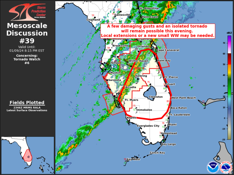
STATUS REPORT #8 ON WW 6

VALID 100030Z - 100140Z

SEVERE WEATHER THREAT CONTINUES RIGHT OF A LINE FROM 45 WSW FMY
TO 20 NNE FMY TO 20 NW MLB.

FOR ADDITIONAL INFORMATION SEE MESOSCALE DISCUSSION 39

..THORNTON..01/10/24

ATTN...WFO...MLB...TBW...

&&

STATUS REPORT FOR WT 6

SEVERE WEATHER THREAT CONTINUES FOR THE FOLLOWING AREAS

FLC009-055-071-100140-

FL
.    FLORIDA COUNTIES INCLUDED ARE

BREVARD 	     HIGHLANDS		 LEE
$$


AMZ552-100140-

CW

.    ADJACENT COASTAL WATERS INCLUDED ARE

VOLUSIA-BREVARD COUNTY LINE TO SEBASTIAN INLET 0-20 NM

$$
THE WATCH STATUS MESSAGE IS FOR GUIDANCE PURPOSES ONLY.  PLEASE
REFER TO WATCH COUNTY NOTIFICATION STATEMENTS FOR OFFICIAL
INFORMATION ON COUNTIES...INDEPENDENT CITIES AND MARINE ZONES
CLEARED FROM SEVERE THUNDERSTORM AND TORNADO WATCHES.
$$

STATUS REPORT #7 ON WW 6

VALID 092330Z - 100040Z

SEVERE WEATHER THREAT CONTINUES RIGHT OF A LINE FROM 40 W FMY TO
35 E SRQ TO 20 NW AGR TO 25 ENE ORL TO 40 ESE SGJ.

FOR ADDITIONAL INFORMATION SEE MESOSCALE DISCUSSION

..THORNTON..01/09/24

ATTN...WFO...MLB...TBW...

&&

STATUS REPORT FOR WT 6

SEVERE WEATHER THREAT CONTINUES FOR THE FOLLOWING AREAS

FLC009-015-027-049-055-071-097-100040-

FL
.    FLORIDA COUNTIES INCLUDED ARE

BREVARD 	     CHARLOTTE		 DESOTO
HARDEE		     HIGHLANDS		 LEE
OSCEOLA
$$


AMZ550-552-GMZ836-856-100040-

CW

.    ADJACENT COASTAL WATERS INCLUDED ARE

FLAGLER BEACH TO VOLUSIA-BREVARD COUNTY LINE 0-20 NM

VOLUSIA-BREVARD COUNTY LINE TO SEBASTIAN INLET 0-20 NM

CHARLOTTE HARBOR AND PINE ISLAND SOUND

COASTAL WATERS FROM BONITA BEACH TO ENGLEWOOD FL OUT 20 NM

$$
THE WATCH STATUS MESSAGE IS FOR GUIDANCE PURPOSES ONLY.  PLEASE
REFER TO WATCH COUNTY NOTIFICATION STATEMENTS FOR OFFICIAL
INFORMATION ON COUNTIES...INDEPENDENT CITIES AND MARINE ZONES
CLEARED FROM SEVERE THUNDERSTORM AND TORNADO WATCHES.
$$

STATUS REPORT #6 ON WW 6

VALID 092230Z - 092340Z

SEVERE WEATHER THREAT CONTINUES RIGHT OF A LINE FROM 80 WSW FMY
TO 35 E PIE TO 25 NNW ORL TO 15 SSE SGJ.

FOR ADDITIONAL INFORMATION SEE MESOSCALE DISCUSSION 37

..THORNTON..01/09/24

ATTN...WFO...MLB...TBW...

&&

STATUS REPORT FOR WT 6

SEVERE WEATHER THREAT CONTINUES FOR THE FOLLOWING AREAS

FLC009-015-027-049-055-071-081-095-097-105-115-117-127-092340-

FL
.    FLORIDA COUNTIES INCLUDED ARE

BREVARD 	     CHARLOTTE		 DESOTO
HARDEE		     HIGHLANDS		 LEE
MANATEE 	     ORANGE		 OSCEOLA
POLK		     SARASOTA		 SEMINOLE
VOLUSIA
$$


AMZ550-552-GMZ836-856-092340-

CW

.    ADJACENT COASTAL WATERS INCLUDED ARE

FLAGLER BEACH TO VOLUSIA-BREVARD COUNTY LINE 0-20 NM

VOLUSIA-BREVARD COUNTY LINE TO SEBASTIAN INLET 0-20 NM

CHARLOTTE HARBOR AND PINE ISLAND SOUND

COASTAL WATERS FROM BONITA BEACH TO ENGLEWOOD FL OUT 20 NM

$$
THE WATCH STATUS MESSAGE IS FOR GUIDANCE PURPOSES ONLY.  PLEASE
REFER TO WATCH COUNTY NOTIFICATION STATEMENTS FOR OFFICIAL
INFORMATION ON COUNTIES...INDEPENDENT CITIES AND MARINE ZONES
CLEARED FROM SEVERE THUNDERSTORM AND TORNADO WATCHES.
$$

STATUS REPORT #5 ON WW 6

VALID 092140Z - 092240Z

SEVERE WEATHER THREAT CONTINUES RIGHT OF A LINE FROM 70 WSW SRQ
TO 10 E PIE TO 20 SW SGJ.

FOR ADDITIONAL INFORMATION SEE MESOSCALE DISCUSSION 37

..THORNTON..01/09/24

ATTN...WFO...MLB...TBW...

&&

STATUS REPORT FOR WT 6

SEVERE WEATHER THREAT CONTINUES FOR THE FOLLOWING AREAS

FLC009-015-027-049-055-057-069-071-081-095-097-101-105-115-117-
119-127-092240-

FL
.    FLORIDA COUNTIES INCLUDED ARE

BREVARD 	     CHARLOTTE		 DESOTO
HARDEE		     HIGHLANDS		 HILLSBOROUGH
LAKE		     LEE		 MANATEE
ORANGE		     OSCEOLA		 PASCO
POLK		     SARASOTA		 SEMINOLE
SUMTER		     VOLUSIA
$$


AMZ550-552-GMZ836-853-856-092240-

CW

.    ADJACENT COASTAL WATERS INCLUDED ARE

FLAGLER BEACH TO VOLUSIA-BREVARD COUNTY LINE 0-20 NM

VOLUSIA-BREVARD COUNTY LINE TO SEBASTIAN INLET 0-20 NM

CHARLOTTE HARBOR AND PINE ISLAND SOUND

COASTAL WATERS FROM ENGLEWOOD TO TARPON SPRINGS FL OUT 20 NM

COASTAL WATERS FROM BONITA BEACH TO ENGLEWOOD FL OUT 20 NM

$$
THE WATCH STATUS MESSAGE IS FOR GUIDANCE PURPOSES ONLY.  PLEASE
REFER TO WATCH COUNTY NOTIFICATION STATEMENTS FOR OFFICIAL
INFORMATION ON COUNTIES...INDEPENDENT CITIES AND MARINE ZONES
CLEARED FROM SEVERE THUNDERSTORM AND TORNADO WATCHES.
$$

STATUS REPORT #4 ON WW 6

VALID 092030Z - 092140Z

SEVERE WEATHER THREAT CONTINUES RIGHT OF A LINE FROM 50 WNW PIE
TO 50 SW OCF TO 5 NNW GNV.

..THORNTON..01/09/24

ATTN...WFO...MLB...TBW...

&&

STATUS REPORT FOR WT 6

SEVERE WEATHER THREAT CONTINUES FOR THE FOLLOWING AREAS

FLC009-015-017-027-049-053-055-057-069-071-081-095-097-101-103-
105-115-117-119-127-092140-

FL
.    FLORIDA COUNTIES INCLUDED ARE

BREVARD 	     CHARLOTTE		 CITRUS
DESOTO		     HARDEE		 HERNANDO
HIGHLANDS	     HILLSBOROUGH	 LAKE
LEE		     MANATEE		 ORANGE
OSCEOLA 	     PASCO		 PINELLAS
POLK		     SARASOTA		 SEMINOLE
SUMTER		     VOLUSIA
$$


AMZ550-552-GMZ830-836-853-856-092140-

CW

.    ADJACENT COASTAL WATERS INCLUDED ARE

FLAGLER BEACH TO VOLUSIA-BREVARD COUNTY LINE 0-20 NM

VOLUSIA-BREVARD COUNTY LINE TO SEBASTIAN INLET 0-20 NM

TAMPA BAY WATERS

CHARLOTTE HARBOR AND PINE ISLAND SOUND

COASTAL WATERS FROM ENGLEWOOD TO TARPON SPRINGS FL OUT 20 NM

COASTAL WATERS FROM BONITA BEACH TO ENGLEWOOD FL OUT 20 NM

$$
THE WATCH STATUS MESSAGE IS FOR GUIDANCE PURPOSES ONLY.  PLEASE
REFER TO WATCH COUNTY NOTIFICATION STATEMENTS FOR OFFICIAL
INFORMATION ON COUNTIES...INDEPENDENT CITIES AND MARINE ZONES
CLEARED FROM SEVERE THUNDERSTORM AND TORNADO WATCHES.
$$

STATUS REPORT #3 ON WW 6

VALID 091935Z - 092040Z

THE SEVERE WEATHER THREAT CONTINUES ACROSS THE ENTIRE WATCH AREA.

FOR ADDITIONAL INFORMATION SEE MESOSCALE DISCUSSION 31

..THORNTON..01/09/24

ATTN...WFO...MLB...TBW...

&&

STATUS REPORT FOR WT 6

SEVERE WEATHER THREAT CONTINUES FOR THE FOLLOWING AREAS

FLC009-015-017-027-049-053-055-057-069-071-075-081-095-097-101-
103-105-115-117-119-127-092040-

FL
.    FLORIDA COUNTIES INCLUDED ARE

BREVARD 	     CHARLOTTE		 CITRUS
DESOTO		     HARDEE		 HERNANDO
HIGHLANDS	     HILLSBOROUGH	 LAKE
LEE		     LEVY		 MANATEE
ORANGE		     OSCEOLA		 PASCO
PINELLAS	     POLK		 SARASOTA
SEMINOLE	     SUMTER		 VOLUSIA
$$


AMZ550-552-GMZ830-836-850-853-856-092040-

CW

.    ADJACENT COASTAL WATERS INCLUDED ARE

FLAGLER BEACH TO VOLUSIA-BREVARD COUNTY LINE 0-20 NM

VOLUSIA-BREVARD COUNTY LINE TO SEBASTIAN INLET 0-20 NM

TAMPA BAY WATERS

CHARLOTTE HARBOR AND PINE ISLAND SOUND

COASTAL WATERS FROM TARPON SPRINGS TO SUWANNEE RIVER FL OUT 20 NM

COASTAL WATERS FROM ENGLEWOOD TO TARPON SPRINGS FL OUT 20 NM

COASTAL WATERS FROM BONITA BEACH TO ENGLEWOOD FL OUT 20 NM

$$
THE WATCH STATUS MESSAGE IS FOR GUIDANCE PURPOSES ONLY.  PLEASE
REFER TO WATCH COUNTY NOTIFICATION STATEMENTS FOR OFFICIAL
INFORMATION ON COUNTIES...INDEPENDENT CITIES AND MARINE ZONES
CLEARED FROM SEVERE THUNDERSTORM AND TORNADO WATCHES.
$$

STATUS REPORT #2 ON WW 6

VALID 091930Z - 092040Z

THE SEVERE WEATHER THREAT CONTINUES ACROSS THE ENTIRE WATCH AREA.

FOR ADDITIONAL INFORMATION SEE MESOSCALE DISCUSSION 33

..THORNTON..01/09/24

ATTN...WFO...MLB...TBW...

&&

STATUS REPORT FOR WT 6

SEVERE WEATHER THREAT CONTINUES FOR THE FOLLOWING AREAS

FLC009-015-017-027-049-053-055-057-069-071-075-081-095-097-101-
103-105-115-117-119-127-092040-

FL
.    FLORIDA COUNTIES INCLUDED ARE

BREVARD 	     CHARLOTTE		 CITRUS
DESOTO		     HARDEE		 HERNANDO
HIGHLANDS	     HILLSBOROUGH	 LAKE
LEE		     LEVY		 MANATEE
ORANGE		     OSCEOLA		 PASCO
PINELLAS	     POLK		 SARASOTA
SEMINOLE	     SUMTER		 VOLUSIA
$$


AMZ550-552-GMZ830-836-850-853-856-092040-

CW

.    ADJACENT COASTAL WATERS INCLUDED ARE

FLAGLER BEACH TO VOLUSIA-BREVARD COUNTY LINE 0-20 NM

VOLUSIA-BREVARD COUNTY LINE TO SEBASTIAN INLET 0-20 NM

TAMPA BAY WATERS

CHARLOTTE HARBOR AND PINE ISLAND SOUND

COASTAL WATERS FROM TARPON SPRINGS TO SUWANNEE RIVER FL OUT 20 NM

COASTAL WATERS FROM ENGLEWOOD TO TARPON SPRINGS FL OUT 20 NM

COASTAL WATERS FROM BONITA BEACH TO ENGLEWOOD FL OUT 20 NM

$$
THE WATCH STATUS MESSAGE IS FOR GUIDANCE PURPOSES ONLY.  PLEASE
REFER TO WATCH COUNTY NOTIFICATION STATEMENTS FOR OFFICIAL
INFORMATION ON COUNTIES...INDEPENDENT CITIES AND MARINE ZONES
CLEARED FROM SEVERE THUNDERSTORM AND TORNADO WATCHES.
$$

STATUS REPORT #1 ON WW 6

VALID 091835Z - 091940Z

THE SEVERE WEATHER THREAT CONTINUES ACROSS THE ENTIRE WATCH AREA.

FOR ADDITIONAL INFORMATION SEE MESOSCALE DISCUSSION 31

..THORNTON..01/09/24

ATTN...WFO...MLB...TBW...

&&

STATUS REPORT FOR WT 6

SEVERE WEATHER THREAT CONTINUES FOR THE FOLLOWING AREAS

FLC009-015-017-027-049-053-055-057-069-071-075-081-095-097-101-
103-105-115-117-119-127-091940-

FL
.    FLORIDA COUNTIES INCLUDED ARE

BREVARD 	     CHARLOTTE		 CITRUS
DESOTO		     HARDEE		 HERNANDO
HIGHLANDS	     HILLSBOROUGH	 LAKE
LEE		     LEVY		 MANATEE
ORANGE		     OSCEOLA		 PASCO
PINELLAS	     POLK		 SARASOTA
SEMINOLE	     SUMTER		 VOLUSIA
$$


AMZ550-552-GMZ830-836-850-853-856-091940-

CW

.    ADJACENT COASTAL WATERS INCLUDED ARE

FLAGLER BEACH TO VOLUSIA-BREVARD COUNTY LINE 0-20 NM

VOLUSIA-BREVARD COUNTY LINE TO SEBASTIAN INLET 0-20 NM

TAMPA BAY WATERS

CHARLOTTE HARBOR AND PINE ISLAND SOUND

COASTAL WATERS FROM TARPON SPRINGS TO SUWANNEE RIVER FL OUT 20 NM

COASTAL WATERS FROM ENGLEWOOD TO TARPON SPRINGS FL OUT 20 NM

COASTAL WATERS FROM BONITA BEACH TO ENGLEWOOD FL OUT 20 NM

$$
THE WATCH STATUS MESSAGE IS FOR GUIDANCE PURPOSES ONLY.  PLEASE
REFER TO WATCH COUNTY NOTIFICATION STATEMENTS FOR OFFICIAL
INFORMATION ON COUNTIES...INDEPENDENT CITIES AND MARINE ZONES
CLEARED FROM SEVERE THUNDERSTORM AND TORNADO WATCHES.
$$
Note:
Click for Complete Product Text.
Tornadoes
Probability of 2 or more tornadoes
|
Mod (50%)
|
Probability of 1 or more strong (EF2-EF5) tornadoes
|
Mod (30%)
|
Wind
Probability of 10 or more severe wind events
|
High (70%)
|
Probability of 1 or more wind events > 65 knots
|
Low (10%)
|
Hail
Probability of 10 or more severe hail events
|
Low (<5%)
|
Probability of 1 or more hailstones > 2 inches
|
Low (<5%)
|
Combined Severe Hail/Wind
Probability of 6 or more combined severe hail/wind events
|
High (80%)
|
For each watch, probabilities for particular events inside the watch
(listed above in each table) are determined by the issuing forecaster.
The "Low" category contains probability values ranging from less than 2%
to 20% (EF2-EF5 tornadoes), less than 5% to 20% (all other probabilities),
"Moderate" from 30% to 60%, and "High" from 70% to greater than 95%.
High values are bolded and lighter in color to provide awareness of
an increased threat for a particular event.


 @NWSSPC