SPC AC 221256
Day 1 Convective Outlook
NWS Storm Prediction Center Norman OK
0756 AM CDT Sat Mar 22 2025
Valid 221300Z - 231200Z
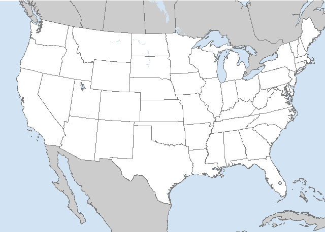
...THERE IS A MARGINAL RISK OF SEVERE THUNDERSTORMS ACROSS EASTERN
KS/NORTHEAST OK TO OZARKS/LOWER MISSOURI VALLEY...
...SUMMARY...
Scattered thunderstorms capable of producing isolated large hail and
strong wind gusts are possible this evening and overnight from
northeast Oklahoma and far northwest Arkansas into eastern Kansas
and much of Missouri.
...Northeast OK/eastern KS to Ozarks/Lower MO Valley...
A shortwave trough will steadily amplify and dig southeastward late
today and tonight across the northern Plains, with deepening surface
lows expected across the South Dakota/Minnesota vicinity as well as
the southern Plains tonight. Modest-caliber low-level moisture
return will precede a southeast-accelerating cold front across the
Plains.
Daytime heating combined with the developing moist plume will lead
to destabilization over eastern Oklahoma and western Arkansas
through late afternoon and early evening, with stronger elevated
instability rapidly developing across eastern Kansas and Missouri
during the evening into the overnight. Indications are that initial
storm development could occur by around 00-03Z over northeast
Oklahoma near the low-level jet axis as moisture spreads into the
heated-air mass and beneath cool temperatures aloft. Strong and
veering winds with height, as well as deepening moisture through 700
mb, will favor cells producing large hail as cells develop into
southern Missouri and possibly far northern Arkansas. Portions of
the OK/KS/AR/MO border vicinity will be reevaluated in subsequent
outlooks for the possibility of a semi-focused hail-related Slight
Risk upgrade. There may also be a low risk of a tornado, though
highly conditional at this time given the modest moisture, related
to the southernmost development closer to the stronger SBCAPE from
far northeast Oklahoma into extreme northwest Arkansas.
Overnight, as a cold front moves east-southeastward across Kansas,
lift will be enhanced further. A few cells or perhaps a cluster of
storms could develop along the front, conditional on capping, with
both hail and wind gust potential. In addition, the unstable air
mass extending north toward the Iowa/Missouri border will support
isolated hail as well within the warm advection regime.
...North-Central High Plains...
Steep lapse rates through a deep layer will develop this afternoon
north of the mid-level jet axis and behind the cold front and
developing surface low to the east. Forecast soundings indicate
minimal buoyancy in this drier air mass, however, moderate northwest
flow and favorable diurnal heating/mixing could yield a few stronger
wind gusts.
..Guyer/Bentley.. 03/22/2025
CLICK TO GET WUUS01 PTSDY1 PRODUCT
NOTE: THE NEXT DAY 1 OUTLOOK IS SCHEDULED BY 1630Z


 @NWSSPC