|
| Mesoscale Discussion 425 |
|
< Previous MD Next MD >
|
|
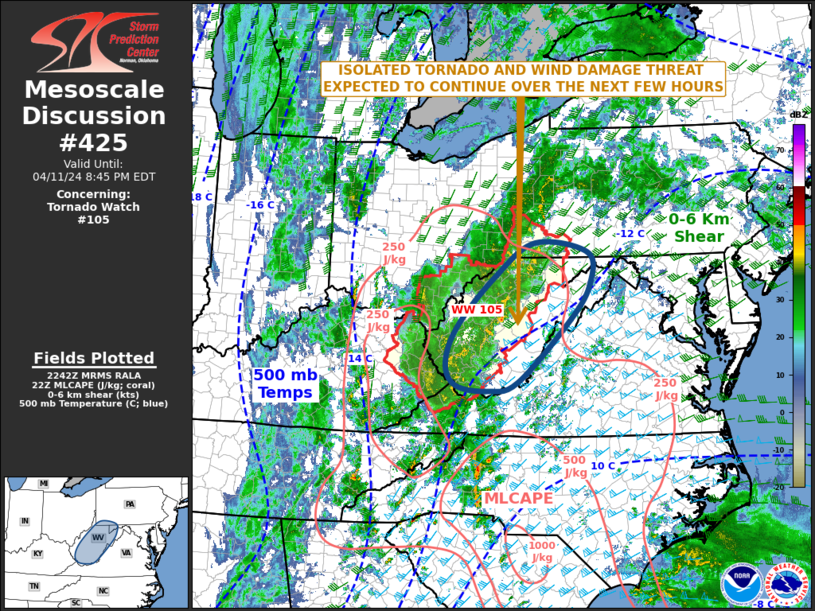
   Mesoscale Discussion 0425
   NWS Storm Prediction Center Norman OK
   0543 PM CDT Thu Apr 11 2024

   Areas affected...West Virginia...Far Western Maryland...Far
   Southwest Pennsylvania

   Concerning...Tornado Watch 105...

   Valid 112243Z - 120045Z

   The severe weather threat for Tornado Watch 105 continues.

   SUMMARY...An isolated tornado and wind-damage threat is expected to
   continue across parts of the central Appalachians for several more
   hours this evening. At this time, it appears that new watch issuance
   to the east of the ongoing watch will be unlikely.

   DISCUSSION...The latest water vapor imagery shows an upper-level
   trough over the Ohio and Tennessee Valleys, with the exit region of
   a mid-level jet moving across the central Appalachians. Large-scale
   ascent appears to be maximized within this feature, which will
   continue to support scattered thunderstorm development this evening.
   The exit region of the jet was also creating moderate deep-layer
   shear over the top of a weakly unstable airmass, with MLCAPE
   estimated between 250 and 500 J/kg. The instability and shear should
   be just enough to continue an isolated tornado and wind-damage
   threat over the next few hours with the watch. An isolated severe
   threat could also develop just to the east of the current watch, but
   the magnitude of the threat is expected to be too marginal for new
   weather watch issuance.

   ..Broyles.. 04/11/2024

   ...Please see www.spc.noaa.gov for graphic product...

   ATTN...WFO...CTP...LWX...RNK...PBZ...RLX...

   LAT...LON   37518051 37348117 37458191 37848214 38518186 39378104
               39978011 39807892 39257887 38637931 37518051
|
|
Top/All Mesoscale Discussions/Forecast Products/Home
|
|


 @NWSSPC