|
| Mesoscale Discussion 424 |
|
< Previous MD Next MD >
|
|
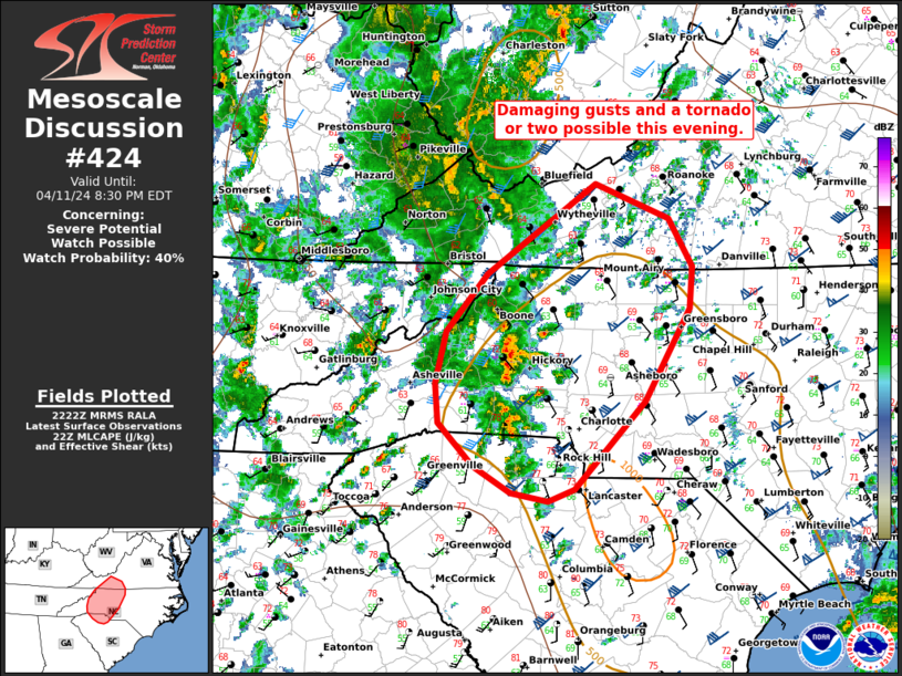
   Mesoscale Discussion 0424
   NWS Storm Prediction Center Norman OK
   0524 PM CDT Thu Apr 11 2024

   Areas affected...portions of western North/South Carolina into
   southern Virginia

   Concerning...Severe potential...Watch possible

   Valid 112224Z - 120030Z

   Probability of Watch Issuance...40 percent

   SUMMARY...The potential for damaging wind gusts and a couple of
   tornadoes may increase through this evening. While there is some
   uncertainty in storm coverage/intensity a watch is possible.

   DISCUSSION...As of 2215 UTC, regional satellite and radar showed
   small storms developing across portions of western NC into northern
   SC. While small, lightning and reflectively structures have
   intensified over the last 30 minutes, indicating deepening updrafts.
   Ongoing within a relatively moist environment (dewpoints in the mid
   60s F) modest low and mid-level lapse rates are contributing to
   500-1000 J/kg of MLCAPE. 60-70 kt of deep-layer shear from area VADs
   and modest forcing for ascent are favorable for storm organization
   with supercell structures.

   While storms have steadily increased in intensity, modest
   buoyancy/lapse rates have so far favored relatively low topped
   convection. However, further maturation is possible, and low-level
   shear is forecast to increase through this evening as storms move
   north/northeast. Effective SRH of 200-350 m2/s2 from SPC
   mesoanalysis may support a risk for a couple of tornadoes with the
   more robust supercells able to become established. Damaging gusts
   will also be possible given strong background flow. Given the
   potential for some increase in the tornado/wind risk this evening, a
   WW is possible.

   ..Lyons/Thompson.. 04/11/2024

   ...Please see www.spc.noaa.gov for graphic product...

   ATTN...WFO...RAH...RNK...CAE...GSP...MRX...

   LAT...LON   36577967 36227970 35458015 34728087 34628114 34688152
               34908191 35268226 35608230 36028219 36508176 37258065
               36977991 36577967
|
|
Top/All Mesoscale Discussions/Forecast Products/Home
|
|


 @NWSSPC