|
| Mesoscale Discussion 152 |
|
< Previous MD Next MD >
|
|
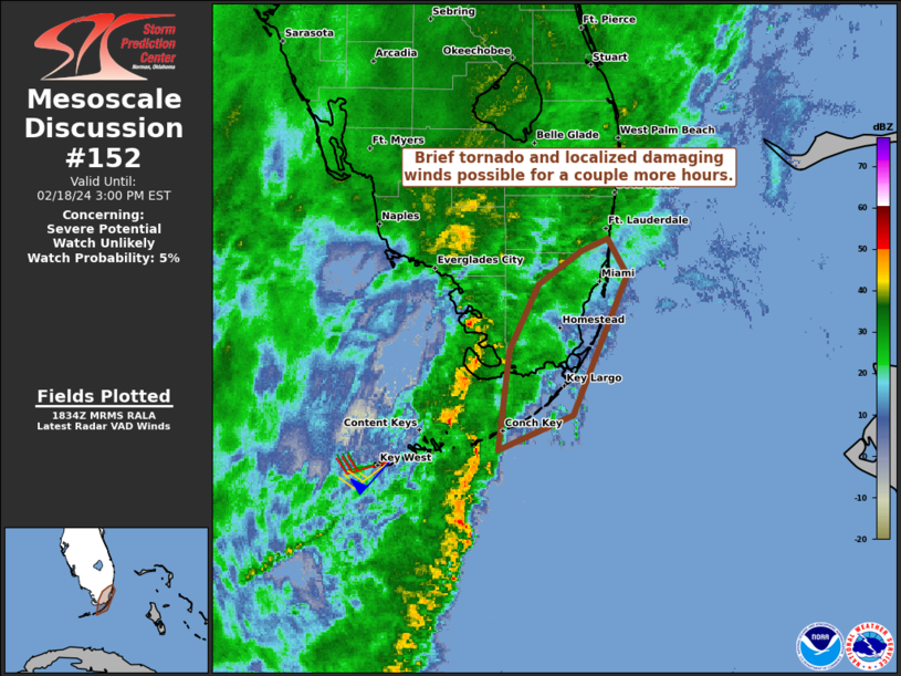
   Mesoscale Discussion 0152
   NWS Storm Prediction Center Norman OK
   1235 PM CST Sun Feb 18 2024

   Areas affected...Far southeast FL and the Upper Keys

   Concerning...Severe potential...Watch unlikely

   Valid 181835Z - 182000Z

   Probability of Watch Issuance...5 percent

   SUMMARY...A brief weak tornado and localized strong to marginally
   severe wind gusts will remain possible with a ragged squall line
   spreading east-northeast across far southeast Florida and the Upper
   Keys.

   DISCUSSION...A ragged QLCS with moderate forward speed of 25-30 kts
   is ongoing from the tip of the Everglades across the Middle Keys
   into the FL Straits. Based on its current track it should spread
   across the Upper Keys and the greater Miami metro area during the
   next couple hours. A diffuse warm front has advanced north as
   advertised by morning guidance with low 70s surface dew points in
   place across the southeast peninsula to mid 70s in the Keys. Despite
   this rich moisture, instability remains quite limited by the poor
   mid-level lapse rates sampled in the morning RAOBs and more recently
   by AMDAR data. As such, convection may remain largely sub-severe as
   it spreads east-northeast. But conditionally, an enlarged low-level
   hodograph per area TDWRs and strong deep-layer shear will support a
   threat for a brief weak tornado (peak gust estimates around 65-95
   mph) and locally strong wind gusts of 45-60 mph. This conditional
   potential will diminish in the wake of the QLCS passage as low-level
   winds become veered.

   ..Grams/Hart.. 02/18/2024

   ...Please see www.spc.noaa.gov for graphic product...

   ATTN...WFO...MFL...KEY...

   LAT...LON   24668092 25328084 25748063 25978031 26048013 25807998
               24888038 24668092
|
|
Top/All Mesoscale Discussions/Forecast Products/Home
|
|


 @NWSSPC