|
| Mesoscale Discussion 153 |
|
< Previous MD Next MD >
|
|
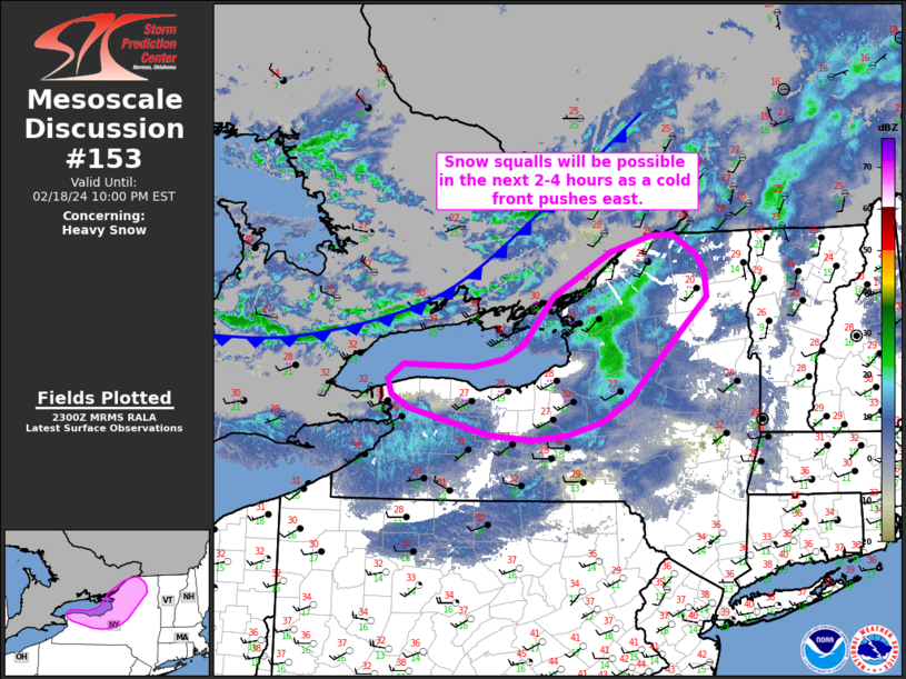
   Mesoscale Discussion 0153
   NWS Storm Prediction Center Norman OK
   0501 PM CST Sun Feb 18 2024

   Areas affected...Northern New York

   Concerning...Heavy snow

   Valid 182301Z - 190300Z

   SUMMARY...Periodic snow squalls will be possible in the coming hours
   as a cold front approaches northern New York.

   DISCUSSION...Recent regional radar composites and surface
   observations show a persistent snow band moving east across
   southeast Ontario. This band is primarily being driven by ascent
   along a cold front - likely through a shallow layer from the surface
   to around 700 mb where lapse rates are on the order of 7 C/km based
   on recent RAP mesoanalyses and forecast soundings. The snow
   band/cold front is expected to continue to push east into upstate NY
   within the next few hours. The combination of persistent frontal
   ascent, steep low-level lapse rates, and 25-30 mph wind gusts (which
   have been observed across southeast Ontario with the passage of the
   band/front) suggests snow squall conditions will be possible. Snow
   squall potential will likely be greatest along the eastern shores of
   Lake Ontario with diminishing confidence in snow squall potential
   with east/southeastern extent as low-level lapse rates begin to
   diminish due to the onset of nocturnal cooling.

   ..Moore.. 02/18/2024

   ...Please see www.spc.noaa.gov for graphic product...

   ATTN...WFO...BTV...ALY...BGM...BUF...

   LAT...LON   42747618 42677673 42737739 43037864 43187890 43357895
               43527872 43507764 43587718 43747689 44307641 44787553
               44977489 44977457 44757421 44577407 44287405 43117527
               42887565 42747618
|
|
Top/All Mesoscale Discussions/Forecast Products/Home
|
|


 @NWSSPC