|
| Mesoscale Discussion 151 |
|
< Previous MD Next MD >
|
|
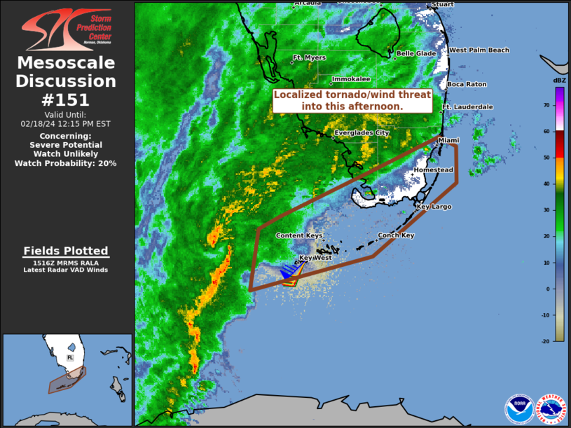
   Mesoscale Discussion 0151
   NWS Storm Prediction Center Norman OK
   0918 AM CST Sun Feb 18 2024

   Areas affected...FL Keys and extreme south FL Peninsula

   Concerning...Severe potential...Watch unlikely

   Valid 181518Z - 181715Z

   Probability of Watch Issuance...20 percent

   SUMMARY...A tornado and localized damaging wind swath will be
   possible as a short-line segment spreads across the Keys and extreme
   south Florida into early afternoon.

   DISCUSSION...A thin and short-line segment is apparent near the Dry
   Tortugas into the FL Straits, within a low-level warm theta-e
   advection regime. The north portion of this segment has shown
   storm-scale organization, with broad rotation and comma-head
   reflectivity structure. This appears to be near/along the
   quasi-stationary front that is draped between the Keys and the
   Everglades, east through about Key Largo. 12Z guidance suggest this
   boundary will attempt to advance north into early afternoon across
   south portions of mainland Monroe and Miami-Dade counties. It is
   plausible that the organizational structure of the short-line
   segment may be maintained east along the baroclinic zone with an
   embedded tornado and severe wind threat. Background environment does
   have limiting factors such as very poor mid-level lapse rates
   (700-500 mb from 4.5 to 5 C/km per 12Z Key West and Miami soundings)
   and minimal change in wind speeds between 1 to 3 km AGL. This
   suggests that any severe threat will be quite localized and focused
   along the surface front.

   ..Grams/Hart.. 02/18/2024

   ...Please see www.spc.noaa.gov for graphic product...

   ATTN...WFO...MFL...KEY...

   LAT...LON   25028199 25508096 25868017 25767997 25387996 24618093
               24268232 24908223 25028199
|
|
Top/All Mesoscale Discussions/Forecast Products/Home
|
|


 @NWSSPC