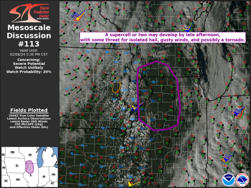
   Mesoscale Discussion 0113
   NWS Storm Prediction Center Norman OK
   0253 PM CST Thu Feb 08 2024

   Areas affected...Parts of northern IL into extreme eastern
   IA/southern WI

   Concerning...Severe potential...Watch unlikely

   Valid 082053Z - 082330Z

   Probability of Watch Issuance...20 percent

   SUMMARY...A supercell or two may develop later this afternoon. Large
   hail, gusty winds, and possibly a tornado will all be possible,
   though coverage of the threat is expected to remain isolated.

   DISCUSSION...Convection is gradually deepening within a cumulus
   field this afternoon from eastern IA/northeast MO into western IL,
   in advance of a mid/upper-level trough approaching the upper MS
   Valley. Low-level moisture remains rather modest across the region,
   with surface dewpoints generally in the mid/upper 40s F. However,
   seasonably strong diurnal heating beneath cold temperatures aloft is
   supporting MLCAPE of around 500 J/kg, along with diminishing MLCINH.
   Destabilization should spread into a larger portion of northern IL
   and southern WI through late afternoon, in conjunction with eastward
   progression of the midlevel cold pool.

   The primary midlevel vorticity maximum and attendant surface cyclone
   are moving northeastward across MN, and large-scale ascent may
   remain rather modest across the effective warm sector. However, a
   low-amplitude shortwave is moving through the base of the
   mid/upper-level trough near the IA/MO border, and may aid in
   thunderstorm development as any remaining convective inhibition is
   removed.

   Strong deep-layer shear across the region will conditionally support
   organized convection, and a supercell or two may eventually evolve
   out of initial storm development. Steep tropospheric lapse rates
   will support large hail and locally gusty winds with the strongest
   storms. Also, despite less than ideal low-level moisture, a tornado
   cannot be ruled out given the presence of favorable low-level shear
   and lapse rates. At this time, coverage of the severe threat is
   expected to remain rather isolated.

   ..Dean/Goss.. 02/08/2024

   ...Please see www.spc.noaa.gov for graphic product...

   ATTN...WFO...LOT...ILX...MKX...DVN...ARX...

   LAT...LON   42549087 42829082 43078992 42928936 42378892 41368878
               40758891 40618938 40569005 40959076 41299078 42549087
|


 @NWSSPC