|
| Mesoscale Discussion 21 |
|
< Previous MD Next MD >
|
|
Mesoscale Discussion 0021
NWS Storm Prediction Center Norman OK
0521 PM CST Mon Jan 08 2024
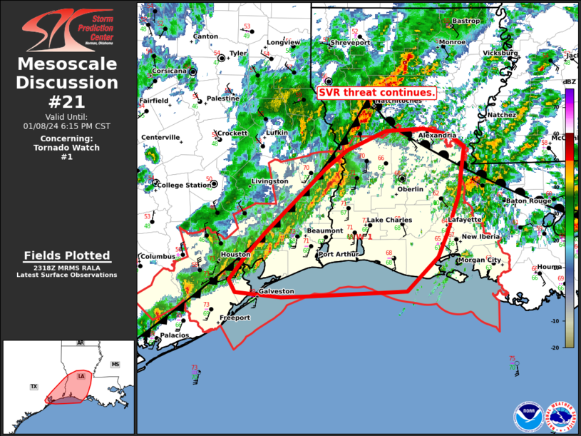
Areas affected...southwest LA and southeast TX
Concerning...Tornado Watch 1...
Valid 082321Z - 090015Z
The severe weather threat for Tornado Watch 1 continues.
SUMMARY...Ongoing storms will continue to pose a risk for damaging
gusts, and hail this evening. Isolated tornadoes will remain
possible near the warm front.
DISCUSSION...As of 2315 UTC a band of thunderstorms was ongoing
across southeast TX into western LA along a surging cold front.
Ahead of the front, a supercell on the TX/LA border is quickly
approaching the northern end of the warm sector. A brief uptick in
intensity is possible as the storm approaches the warm front.
However, the narrow warm sector and the encroaching cold front may
result in gradual elevation above the surface with time. Still a
brief tornado, wind and hail risk may evolve with the storm over the
next hour.
Farther southwest recent lightning trends show the undercutting
front has surged ahead of the convection limiting updraft strength.
While storms have been slow to mature, an increase in the nocturnal
low-level jet may support a slow uptick in storm coverage and
intensity later this evening. Veered low-level flow would support a
broken/linear band of storms with eventual upscale growth into a
more organized QLCS possible with time. Damaging wind gusts and
embedded circulations capable of tornadoes appear possible across
the remainder of WW1.
..Lyons.. 01/08/2024
...Please see www.spc.noaa.gov for graphic product...
ATTN...WFO...JAN...LIX...LCH...SHV...HGX...
LAT...LON 29319396 29289444 29359513 29519522 29789500 30099470
30949380 31189348 31439291 31469235 31379196 31239174
30609182 30099200 29819213 29379260 29319396
|
|
Top/All Mesoscale Discussions/Forecast Products/Home
|
|


 @NWSSPC