|
| Mesoscale Discussion 22 |
|
< Previous MD Next MD >
|
|
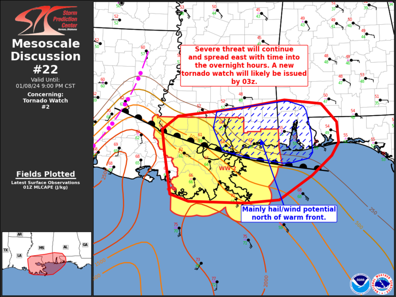
   Mesoscale Discussion 0022
   NWS Storm Prediction Center Norman OK
   0703 PM CST Mon Jan 08 2024

   Areas affected...southeast LA...far southern MS/AL

   Concerning...Tornado Watch 2...

   Valid 090103Z - 090300Z

   The severe weather threat for Tornado Watch 2 continues.

   SUMMARY...All severe hazards remain possible across Tornado Watch 2.
   An additional isolated hail and wind risk may extend just outside of
   the watch across parts of southern Mississippi/Alabama in the short
   term.

   DISCUSSION...Warm advection storms continue to shift northeast
   across parts of southeast LA into southern MS/AL. This convection is
   elevated and to the cool side of a warm front draped across southern
   LA, and extending just offshore from MS/AL. Strong vertical shear,
   as evident in very large and curved hodographs in regional VWP data,
   will allow for some maintenance and organization of stronger
   updrafts despite weakening instability with northward extent. These
   stronger cells will pose some risk for hail given modest midlevel
   lapse rates and favorable shear, as well as an isolated risk for
   strong gusts.

   A cold front and associated line of convection is currently oriented
   from northeast to southwest LA, and will continue to shift east
   overnight. A narrow warm sector currently confined to far southern
   LA will continue to support tornado potential with any convection
   that may develop ahead of the eastward advancing line of convection,
   or within the line itself with any QLCS/mesovortex circulations. The
   warm front will gradually lift northward overnight as a surface low
   deepens as lifts northeast across the Lower MS/TN Valley. This will
   allow higher-quality Gulf moisture moving into far southern MS/AL
   and eventually the western FL Panhandle. Portions of WW 2, which
   expires at 03z, may need to be included in a new tornado watch,
   which would extend downstream into southern MS/AL and the western FL
   Panhandle.

   ..Leitman.. 01/09/2024

   ...Please see www.spc.noaa.gov for graphic product...

   ATTN...WFO...MOB...JAN...LIX...LCH...

   LAT...LON   31019110 31238939 31408824 31308724 30888683 30398679
               30098698 29658751 29088839 29018929 29049079 29209128
               30209145 30719152 31019110
|
|
Top/All Mesoscale Discussions/Forecast Products/Home
|
|


 @NWSSPC