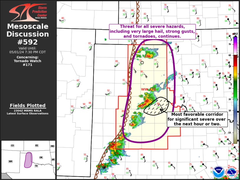
   Mesoscale Discussion 0592
   NWS Storm Prediction Center Norman OK
   0607 PM CDT Wed May 01 2024

   Areas affected...Eastern TX Panhandle...Far Northwestern TX...Far
   Southwestern/Western OK

   Concerning...Tornado Watch 171...

   Valid 012307Z - 020030Z

   The severe weather threat for Tornado Watch 171 continues.

   SUMMARY...Threat for all severe hazards, including very large hail
   from 2.5" to 3.5" in diameter, strong gusts up to 75 mph, and
   tornadoes continues across the eastern TX Panhandle.

   DISCUSSION...Several supercells are currently ongoing across the
   eastern TX Panhandle, including a pair of tornadic storms, one over
   Roberts Ochiltree Counties in the northeast TX Panhandle and the
   other farther south in Briscoe and Hail Counties. Both of these
   storms, as well as the other supercells developing southwestward
   from the Panhandle into the Texas South Plains, are in a favorable
   environment for persistence. Main factor influencing overall updraft
   maintenance and storm persistence will be storm
   mergers/interactions. Some secondary influence from anvil shading
   and resulting boundary-layer cooling is possible, although this
   could be offset by continuing low-level moisture advection. The
   general expectation is for storms to persist, with perhaps one
   substantial storm eventually emerging out of the cluster over
   Briscoe and Hall Counties. Given the unimpeded inflow and
   anticipated strengthening of low-level flow, this storm would likely
   represent the best candidate for a significant severe weather,
   including very large hail, strong gusts, and tornadoes, over the
   next hour or two.

   Storm motion has been relatively slow thus far, generally 15 to 20
   kt, with a few storm moving even slower. As such, this activity will
   likely remain in the eastern TX Panhandle (i.e. within Tornado Watch
   171) for the next few hours. Even so, trends will be monitored for
   faster storm motion and the potential for activity to move into
   western OK earlier.

   ..Mosier.. 05/01/2024

   ...Please see www.spc.noaa.gov for graphic product...

   ATTN...WFO...OUN...LUB...AMA...

   LAT...LON   36030139 36650085 36369982 34399974 33330031 33380173
               35130151 36030139
|


 @NWSSPC