|
| Mesoscale Discussion 593 |
|
< Previous MD Next MD >
|
|
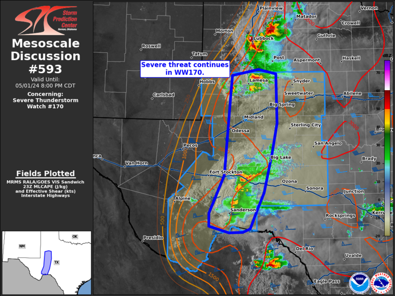
   Mesoscale Discussion 0593
   NWS Storm Prediction Center Norman OK
   0658 PM CDT Wed May 01 2024

   Areas affected...southwestern Texas

   Concerning...Severe Thunderstorm Watch 170...

   Valid 012358Z - 020100Z

   The severe weather threat for Severe Thunderstorm Watch 170
   continues.

   SUMMARY...Severe threat continues within WW170. Instances of severe
   hail and damaging wind will continue over the next couple of hours.

   DISCUSSION...Thunderstorm activity continues in the northern and
   southern portions of WW170. To the north, clustered cell activity
   with transient supercell structures will continue to support risk of
   instances of large hail and damaging wind. Recent reports of hail as
   large as 1.5 in and gusts 50+ mph have been noted in this region.

   Further south, storms have made attempts to grow upscale along
   outflow, which will likely support a shift to increase in threat for
   damaging wind (possibly as high as 70 mph) threat in the short term,
   though instances of large hail will be possible.

   Activity is largely supported dryline forcing and will likely wane
   in coverage after sunset with the end of daytime heating. The
   propensity for anvil spread downwind has also likely limited the
   threat of further development with eastern extent, as witnessed by
   meager development along a northward moving outflow boundary near
   Upton and Reagan Counties.

   ..Thornton/Guyer.. 05/01/2024

   ...Please see www.spc.noaa.gov for graphic product...

   ATTN...WFO...EWX...SJT...LUB...MAF...

   LAT...LON   30130285 30890251 32380238 32890232 33020170 32930130
               31940128 31340140 30550159 30080179 29820190 29750208
               29750239 29880286 30130285
|
|
Top/All Mesoscale Discussions/Forecast Products/Home
|
|


 @NWSSPC